1

I have a shapefile of points with 16 fields associated with each point - these four fields are Q1, Q2, Q3, and Q4 (quadrants). Each quadrant field contains a value that represents a distance from each point in nautical miles.

For example I have a lat/lon point with values: Q1 = 10,
Q2 = 20,
Q3 = 30,
Q4 = 20,

So one point, with 4 rays (one in each quadrant) a Q# distance away from the point, and I want to calculate a round-ish polygon around the point based on these 4 distances.

I need to do this programmatically hopefully using arcpy, numpy, or some other python module.

I was thinking to use the degree-distance tool on arcmap, but I beleive that can only be done by "point and click" and not by an arcpy tool.

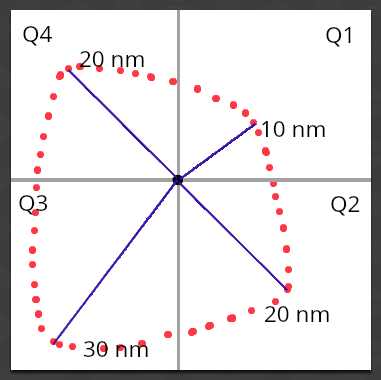
Black center point is my point, with the four blue rays extending in each quadrant a distance away from the point, and I want to compute a round-ish polygon connecting these 4 rays

2
  • Radius itself is usually not enough to find the coordinates of a point, so unless you're assuming 45°, a roundish polygon sounds challenging. If you just want a radius per quadrant, this post has some interesting code. community.esri.com/thread/… Commented Jan 22, 2018 at 20:53
  • 1
    Here's a similar answer assuming the distance is along the axes. You could plug in sin/cos of some angles if desired. gis.stackexchange.com/questions/188139/… Commented Jan 22, 2018 at 21:06

0

Browse other questions tagged or ask your own question.