3

I am georeferencing images in ArcGIS Pro using control points. After I export the control points and save the image, it shifts downward and displays in a different location. Now when I open the image, it loads into this new incorrect location.

When I try to re-georeference by loading the control points, the control points stay in the same place, and the RMSE does not change, but the image stays in its incorrect location. This result does not change when I close/reopen Pro and reload the control points, or do the same from ArcMap.

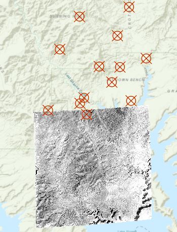
In the screenshot below, the B & W image is what is being georeferenced. The control points are where the image used to be aligned, but it has shifted southward. I have encountered this error continuously while georeferencing in ArcGIS Pro.

What could be causing this?

enter image description here


I have found that the image only shifts in this way when the georeferencing results are saved for the first time. Subsequent saves will not cause unwanted shifts. My workaround is to save the results after using the move/scale tools, and then moving the image back to its proper location before starting with control points.

7
  • What sort of image is it? There is a quirk with some formats that support scanline orientations other than top left first which can cause havoc with georeference: the bottom scanline is correct but the image is flipped. If this is the case you might have better luck converting the image to ERDAS IMG prior to georeference.. Commented Feb 7, 2018 at 23:17
  • What projection are you setting up to ?
    – PROBERT
    Commented Feb 8, 2018 at 0:54
  • I am working with TIFF images, would JPG perform better or have the same issue? The projection is Transverse Mercator, coordinate system "NAD 1983 UTM Zone 12N"
    – EskimoMan
    Commented Feb 8, 2018 at 3:21
  • In the background of the image, is that a basemap ?
    – PROBERT
    Commented Feb 8, 2018 at 21:12
  • Yes, it is ESRI's topographic basemap. I am actually using a current imagery layer to georeference but this basemap was good to visually highlight the issue.
    – EskimoMan
    Commented Feb 9, 2018 at 2:58

1 Answer 1

1

This happens when you do the update georeferencing for the second time in another word the raster image already has a world file associated with.

Workaround: either using "Rectify" rather than update georeferencing or delete all associated files

Your Answer

By clicking “Post Your Answer”, you agree to our terms of service and acknowledge you have read our privacy policy.

Not the answer you're looking for? Browse other questions tagged or ask your own question.