1

When conducting kernel density analysis in ArcGIS (10.2) if you leave the search radius field blank I realise it uses a default based on an algorithm.

Is there any easy/quick way to find out what search radius was applied after a new surface is created? In the geoprocessing results it's left blank.

3
  • Search radius (also called bandwidth) is computed according to Silverman's Rule of Thumb, Please check this link and this link2
    – Moh
    Commented Mar 23, 2018 at 18:01
  • Thanks for your response. However, I'm aware it's based on that rule of thumb but what I would like to know if what value ArcGIS has implemented based on that rule. There is no value given in the results. Is the only option to try decipher the formula and apply to my dataset? Commented Mar 24, 2018 at 20:46
  • It depends on how you performed the KDE. If you left enough of a border around the original points, so that little or nothing was lost off the edges, then a deconvolution of the KDE with the original point dataset will recover the kernel itself, from which you may estimate its radius. When the result is cut off at the edges of the raster, though, then the deconvolution will be messy and at best can give some guidance concerning the radius.
    – whuber
    Commented Mar 25, 2018 at 19:53

1 Answer 1

2

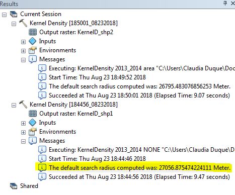
If you look in the results tab of ArcGIS you can see them enter image description here

Your Answer

By clicking “Post Your Answer”, you agree to our terms of service and acknowledge you have read our privacy policy.

Not the answer you're looking for? Browse other questions tagged or ask your own question.