3

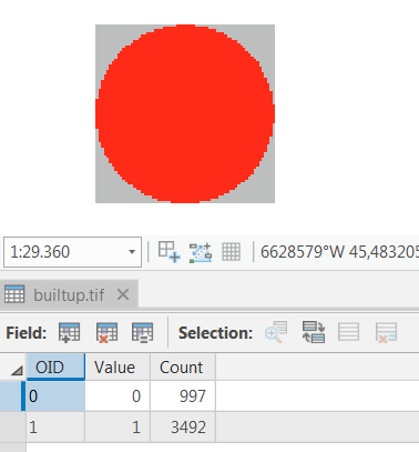
I have a binary raster (.tif) in ArcGIS that shows builtup areas (value=1) and non builtup areas (value=0) like this:

enter image description here

In order to make a proximity analysis, I need to iterate through the raster with arcpy/python and for each cell (i) get the distance to EVERY other cell (j) with value=1 within in a given radius around the current cell (i) and write all those distance values to a list/array.

Is there a performant way to do this using Python?

I know there is the EucDistance tool in ArcGIS:

enter image description here

but it may not be the smartest, to create several thousand new rasters.

My plan was to use a RasterToNumpyArray and then calculate on the numpy array

So far I tried the following Python code:

import numpy
from scipy.spatial import distance

def dist_euclid(cell_a, cell_b):
    dist = distance.euclidean(cell_a, cell_b)
    return dist

'''Masking is important to speed up processes'''
def cmask(coords, radius, array):
    a, b = coords[0], coords[1]
    nx, ny = array.shape
    y, x = numpy.ogrid[-a:nx - a, -b:ny - b]
    # create mask where each value in radius around coords is true and everything else is false
    mask = x * x + y * y <= radius * radius

    # reshape mask to rectangular shape
    i, j = numpy.where(mask)
    indices = numpy.meshgrid(numpy.arange(min(i), max(i) + 1),
                             numpy.arange(min(j), max(j) + 1),
                             indexing='ij')
    masked_array = array[tuple(indices)]
    return masked_array

def calcCellDistancesForEachCellInRaster(in_array, buffer_size):
    '''For each cell make slice sub-array around the cell and calculate distances to every other cell (value=1)'''
    dist_arr = []
    for (source_x, source_y), source_value in numpy.ndenumerate(in_array):
        if source_value == 1:
            masked_array = cmask([source_x, source_y], buffer_size, in_array)
            for (target_x, target_y), target_value in numpy.ndenumerate(masked_array):
                if target_value == 1 and ([source_x, source_y] != [target_x, target_y]):
                    dist = dist_euclid([source_x, source_y], [target_x, target_y])
                    if dist <= buffer_size:
                        dist_arr.append(dist)
                # print("dist from %s to %s = %s" % ([source_x, source_y], [target_x, target_y], dist))
                else:
                    pass
        else:
            pass
    return dist_arr

# Create a simple array from scratch using random values
myArray = numpy.random.randint(2, size=(100, 100))
myArray.shape = (100, 100)

dist_arr = calcCellDistancesForEachCellInRaster(myArray, 2)
6
  • For a question about performance of Python code I think you will also need to describe the hardware and OS configuration on which you are attaining that performance.
    – PolyGeo
    Commented May 4, 2019 at 22:39
  • What was the difference in performance between your EucDistance and other Python code? Did they produce identical results from identical inputs?
    – PolyGeo
    Commented May 6, 2019 at 11:19
  • The arcpy EucDistance does not iterate over every cell of the array and so far I did not find any other code that does so. Hence, I could not test other codes Commented May 6, 2019 at 11:30
  • 2
    An idea, convert your raster to a point dataset then call the generate near table tool. See how that performs?
    – Hornbydd
    Commented May 10, 2019 at 12:56
  • What kind of output you need? Is it a raster of minimum distance extracted from dist_arr? Does buffer vary over area of interest?
    – FelixIP
    Commented Jun 5, 2019 at 22:10

1 Answer 1

1

I think this script does what you want, without iterating over each pixel in myArray:

import numpy as np
import scipy.ndimage as nd
import matplotlib.pyplot as plt

# Create a function that generates a circle (inside a square-shaped array) with
# different index values for each unique pixel and the corresponding distance to
# the center.
def make_circles(index):
    array_shape = (radius*2+1, radius*2+1)

    circle_index = np.zeros(array_shape) * np.nan
    circle_distance = np.zeros(array_shape) * np.nan

    a,b = (radius, radius)
    nx,ny = circle_index.shape
    y,x = np.ogrid[-a:nx-a,-b:ny-b]

    mask = x*x + y*y <= radius*radius
    mask[a,b] = False

    pixels_in_mask = np.sum(mask)

    circle_index[mask] = np.arange(0, pixels_in_mask, 1)
    circle_distance[mask] = np.sqrt(x*x + y*y)[mask]

    return circle_index, circle_distance

# Generate some dummy data
x = 100
y = 100
my_array = np.random.randint(2, size=(x, y))

# specify the radius in which to search for pixels in my_array with value = 1.
radius = 10

# Create circles.
circle_index, circle_distance = make_circles(radius)

plt.figure(1)
plt.title("Each pixel has a unique index number")
plt.imshow(circle_index)
plt.colorbar()

# Determine the maximum amount of pixels for which the distance 
# needs to be calculated per pixel.
distances_per_pixel = np.int(np.nanmax(circle_index) + 1)

# Create an array in which the results will be stored.
distances = np.zeros((distances_per_pixel, x, y))

# Determine the distances from every pixel to the current relative pixel as 
# defined by circle_index.
for position in circle_index[np.isfinite(circle_index)]:

    distance = circle_distance[circle_index == position][0]

    mask = np.fliplr(np.flipud(np.where(circle_index != position, 0, 1)))

    distance_map = nd.filters.convolve(my_array, mask, mode = 'constant', cval = 0.0) * distance

    distance_map[distance_map == 0.] = np.nan

    distances[np.int(position), :, :] = distance_map

# Each layer in the distances array corresponds to the "unique index number" as shown
# in figure 1. e.g. distances[3,:,:] shows a map that gives the distance to the circle_pixel
# with number 3, IF that pixel has value 1 in my_array.

# Calculate some other things, for example the shortest distance within a pixels
# radius to a pixel with my_array = 1.
shortest_distances = np.nanmin(distances, axis = 0)
longest_distances = np.nanmax(distances, axis = 0)
mean_distances = np.nanmean(distances, axis = 0)

# Plot a map showing the shortest distances.
plt.figure(2)
plt.imshow(shortest_distances, vmin = 0, vmax = radius)
plt.colorbar()

Be carefull though, as you increase the radius of you search area around each pixel, the size of the "distances" array will grow fast. Requiring more and more RAM-memory.

9
  • Your code does not "make" the circles around each pixel of the source array (my_array), right? In my case I would have to do the for-loop for every pixel, or am I taking this the wrong way? Commented May 20, 2019 at 20:38
  • well it does (kindoff), the "nd.filters.convolve" puts the circle on top of each pixel. But this is very fast and more or less independent of your size of my_array. What does have an influence on the speed (and on the for-loop) is the size of the circle. I.e. the more pixels are inside the circle, the longer the for-loop will be be and the larger the distances array will become. Commented May 21, 2019 at 7:08
  • Ok, it works very fast but (as you said) it runs me into a Memory Error, when testing it with a realistic raster Commented May 21, 2019 at 18:41
  • well just to be clear, the memory error is probably cause by your radius (so not your "realistic raster"). What you could try to do is completely removing the " distances" array, and instead saving the "distance_map" variable to a Gtiff or netcdf or something. Then later you can do your analysis on them, depending on what you want to do with them. Commented May 22, 2019 at 7:24
  • In my case it is already the np.zeros (distances = np.zeros((distances_per_pixel, x, y))) that is causing the error. Because x and y have to be the same as the source raster dimensions right? Commented May 22, 2019 at 12:59

Your Answer

By clicking “Post Your Answer”, you agree to our terms of service and acknowledge you have read our privacy policy.

Not the answer you're looking for? Browse other questions tagged or ask your own question.