2

I have a dataset of plants, they are many different plant species that are given a numerical code in a column in the attribute table, but they are located in different land types which was also identified in another column , I want to make a selection that highlights the plant (or points) that share the same species ID but are located in different land types. Here is an example:

enter image description here

I want to know if there is a tool that I can use to select the points with OID 2, 3, 7, 8, and 9 since they are grouped by plant species but there is at least one point (i.e. plant) located in different land Types than all the other points that share the same Species ID. I am using ArcMap 10.2.1.

Quick note: there is no map or layer for the Land Type field.

2
  • 1
    Use the summary stats tool, case field is species & land type, but count on land type. This will identify the species of interest. Then look at help file about relating tables.
    – Hornbydd
    Commented Mar 10, 2021 at 17:56
  • If you also want to investigate ArcPy/Python then your question will need a code attempt to be included.
    – PolyGeo
    Commented Mar 10, 2021 at 21:17

1 Answer 1

0

Convert land type to integers

enter image description here

Join it to original and populate new field (integer).

enter image description here

Apply summary statistics:

arcpy.Statistics_analysis(in_table="Area_Units", out_table="in_memory/abc", statistics_fields="LU STD", case_field="SPECIE")

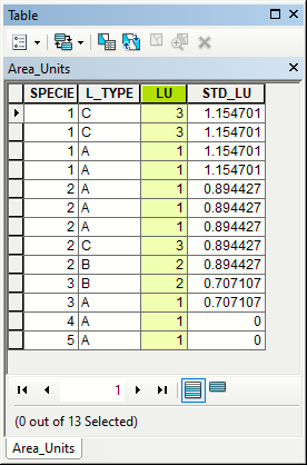
Output with summary table joined to original:

enter image description here

Your records are those where STD_LU > 0

Your Answer

By clicking “Post Your Answer”, you agree to our terms of service and acknowledge you have read our privacy policy.

Not the answer you're looking for? Browse other questions tagged or ask your own question.