2

From what I understand any dataset (GCS or PCS) in QGIS must be "reprojected on the fly" according to the project CRS when viewing the data as a map onscreen.

So my question is what type of "display projection" does QGIS apply when I set the project CRS to something geographic, such as EPSG:4326? Is it an equirectangular projection, or something similar, displayed onscreen?

I have read Lesson 6.1 (Reprojecting and Transforming Data) which suggests that the project CRS parameter field is what determines the projection onscreen. However, I'm unclear of which lines might define the projection with EPSG:4326.

WGS 84
WKT
GEOGCRS["WGS 84",
    DATUM["World Geodetic System 1984",
        ELLIPSOID["WGS 84",6378137,298.257223563,
            LENGTHUNIT["metre",1]]],
    PRIMEM["Greenwich",0,
        ANGLEUNIT["degree",0.0174532925199433]],
    CS[ellipsoidal,2],
        AXIS["geodetic latitude (Lat)",north,
            ORDER[1],
            ANGLEUNIT["degree",0.0174532925199433]],
        AXIS["geodetic longitude (Lon)",east,
            ORDER[2],
            ANGLEUNIT["degree",0.0174532925199433]],
    USAGE[
        SCOPE["unknown"],
        AREA["World"],
        BBOX[-90,-180,90,180]],
    ID["EPSG",4326]]
Proj4
+proj=longlat +datum=WGS84 +no_defs
Extent
-180.00, -90.00, 180.00, 90.00
1
  • QGIS works with the Proj4-part of CRS definitions.
    – Erik
    Commented Jul 22, 2021 at 14:00

1 Answer 1

4

QGIS converts your geographic data to the coordinates of the project coordinate system then scales them linearly to fit the screen image.

So with EPSG:4326 as the project CRS, one inch on your screen up or down is some number of degrees of latitude, and one inch left or right is the same number of degrees of longitude (or should be unless your screen isn't configured properly).

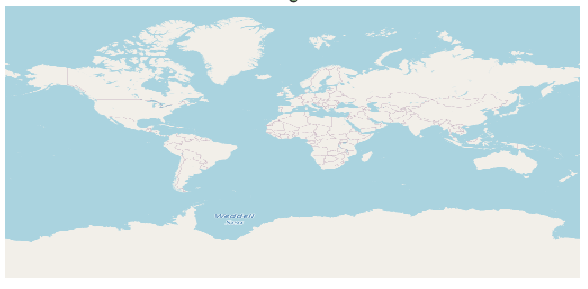
This is why a full OSM globe looks like a 2x1 aspect ratio - it has almost 180 degrees from pole to pole and 360 degrees around the equator. I say almost because OSM is only defined up to 85 degrees N/S of the equator (because its EPSG:3857 web mercator coords).

enter image description here

All the other info in the CRS text that you pasted is used for when converting to or from EPSG:4326. If your data is stored in EPSG:4326 then it is just painted onto a square grid system on screen. Otherwise it is transformed to EPSG:4326 (using those parameters for the ellipsoid etc) and then painted onto a square grid system on screen.

Same applies for any other project CRS - convert data to that CRS and paint it onto a (scaled) square grid in those coordinates on screen.

Your Answer

By clicking “Post Your Answer”, you agree to our terms of service and acknowledge you have read our privacy policy.

Not the answer you're looking for? Browse other questions tagged or ask your own question.