I'd like to know a way to detect overshoot lines (such as flyovers, over/underpasses) in road network through queries in PostGIS to validate topological connections.
This is a sample network:
CREATE TABLE net (id integer, geom geometry(MultiLineString, 4326));
INSERT INTO net (id, geom)
VALUES (1,ST_GeomFromText('MULTILINESTRING((136.63964778201967 36.58031552554121,136.64078637948796 36.57968013023401,136.6414207216891 36.579313967665655,136.64203092428795 36.578959650067986,136.6428838673968 36.57843301697034,136.6438347098042 36.577844992552514))', 4326)),
       (2,ST_GeomFromText('MULTILINESTRING((136.64039880046448 36.57933335255234,136.64078637948796 36.57968013023401,136.64119407544638 36.580076445271914,136.64165541506554 36.58051798901414))', 4326)),
       (3,ST_GeomFromText('MULTILINESTRING((136.64039880046448 36.57933335255234,136.64044439789086 36.578869185464725))', 4326)),
       (4,ST_GeomFromText('MULTILINESTRING((136.6409003730539 36.57873995108804,136.6414207216891 36.579313967665655,136.64222404380473 36.580108753416425))', 4326)),
       (5,ST_GeomFromText('MULTILINESTRING((136.6416232292288 36.57843409435816,136.64203092428795 36.578959650067986))', 4326)),
       (6,ST_GeomFromText('MULTILINESTRING((136.64203092428795 36.578959650067986,136.64244666738 36.57935489221467,136.64283290461503 36.57974259264671))', 4326)),
       (7,ST_GeomFromText('MULTILINESTRING((136.64250969906357 36.57802376968141,136.6428838673968 36.57843301697034,136.64326608196427 36.578854108330574))', 4326)),
       (8,ST_GeomFromText('MULTILINESTRING((136.64364829653186 36.577513284810436,136.6438347098042 36.577844992552514))', 4326)),
       (9,ST_GeomFromText('MULTILINESTRING((136.6438347098042 36.577844992552514,136.64412438862985 36.57833070559775))', 4326));
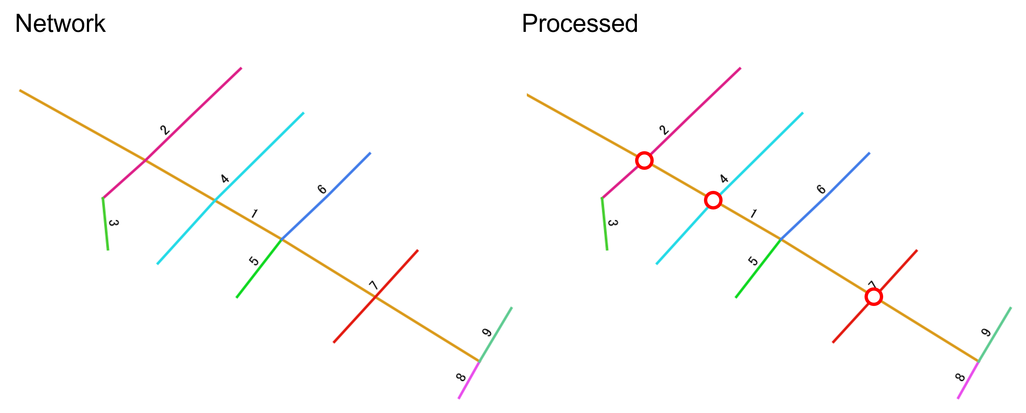
As illustrated in the following image, this network has 9 lines where line 2, 4 and 7 do not topologically connected to line 1. I need to generate points and export it as a new table at the corossing points of those links as shown in the right-hand side figure.
I tried to search for the solutions but could not find so far.
Actually I posted a similar question Detecting overshoot lines in road network (flyovers, over/underpasses) in QGIS but I would like to be able to manipulate it in PostGIS as well.

