1

I have two large-ish shapefiles.

Shapefile 1:

One can be downloaded from here:

https://data.statistik.gv.at/data/OGDEXT_DSR_1_STATISTIK_AUSTRIA_20111031.zip

  • It is ~20 MB in size
  • Seems to be super detailed
  • It has three features (classes of settlement) and two columns

When I print the object it takes forever to load the output which looks roughly like this:

Simple feature collection with 3 features and 2 fields
Geometry type: MULTIPOLYGON
Dimension:     XY
Bounding box:  xmin: 112294.6 ymin: 275328.4 xmax: 685584 ymax: 570580.4
Projected CRS: SOURCECRS

Shapefile 2:

Simple feature collection with 2115 features and 2 fields
Geometry type: MULTIPOLYGON
Dimension:     XY
Bounding box:  xmin: 112518.2 ymin: 275472 xmax: 685444.5 ymax: 570431.1
Projected CRS: SOURCECRS

Now I would like to find out how much area of each polygon is intersecting with each class in the first shapefile (the settlement layer). A normal st_intersection() takes way too long. It did not finish and I let it run for the entire day.

How do I speed this up, perhaps by chunking up some layers?

8
  • 2
    Your first dataset is MULTIPOLYGONs but you talk about "each polygon". Do you mean each polygon within the MULTIPOLYGONs or do you mean each of the three features? Can you show us the st_intersection function that you tried? Its possible that splitting the features into POLYGON geometry (89361 of them) might be faster.
    – Spacedman
    Commented Jun 23, 2022 at 7:56
  • 1
    The first shapefile ("DSR") looks like its a polygonised raster because all the polygons are made from small squares, in which case it might be simpler to try and get a raster version of this and work with that.
    – Spacedman
    Commented Jun 23, 2022 at 8:15
  • 1
    Another idea: your DSR shapefile appears to be a national coverage of three categories, so you could drop the largest or most complicated one and imply the intersection with that category.
    – Spacedman
    Commented Jun 23, 2022 at 8:51
  • 1
    The DSR shapefile appears to be a polygon version of a grid in EPSG:3035, a European CRS, but transformed to an Austrian CRS. If you can't get the original raster it might be possible to infer the grid parameters and reconstruct it knowing the original CRS is 3035.
    – Spacedman
    Commented Jun 23, 2022 at 8:53
  • 1
    They may be 31287 now, but the DSR file is a slightly rotated grid in that coordinate system - hard to see from a full plot but if you can zoom in (I loaded it into QGIS for investigation) you'll see its not aligned to the NSEW grid in 31287. Changing the QGIS project projection to 3035 (so it was doing on-the-fly reprojection) resulted in a perfectly aligned grid of squares, which makes me think this came from a 3035 raster that was polygonized and then transformed to 31287. Getting back to the original 3035 raster if possible would be a Good Thing.
    – Spacedman
    Commented Jun 23, 2022 at 16:11

2 Answers 2

1

What you can also do is to use the parallel processing with smaller intersections. For example, iterating or using each core to do the process for one unit from your region layer.

This is the process:

  1. Read layers.
  2. Validate geometries (most of the time this open layers come with some problems that can ruin your operations).
  3. Set parallel parameters.
  4. Run the code (I did crop and then inetersection, but you can change it to use directly the intersection).
  5. Merge results of parallel process.
  6. Export.

Here is the code:

# PARALLLEL INTERSECTION OF LARGE LAYERS
library(sf)
library(mapview)
library(s2)
library(tictoc)
library(parallel)
library(doParallel)

# a download: https://data.statistik.gv.at/data/OGDEXT_DSR_1_STATISTIK_AUSTRIA_20111031.zip
# b download: https://data.statistik.gv.at/data/OGDEXT_GEM_1_STATISTIK_AUSTRIA_20220101.zip

# read data
a <- read_sf('./data/20111031/STATISTIK_AUSTRIA_DSR_20111031.shp')
b <- read_sf('./data/20220101/STATISTIK_AUSTRIA_GEM_20220101.shp')

# Check layers
# mapview(a)+b

tic()
# Correct topology (this is just a recommendation)
# This can take a while but it worth
a <- st_make_valid(st_cast(a, "POLYGON")) # transform into POLYGONS
b <- st_make_valid(b)
toc()

tic()
# Process in parallel (intersection by "village" (name) in b)
# Proceso de cálculo de para cada TIPO (MUNI, EEO, ESF, EEO_ESF)
cl = parallel::makeCluster(detectCores(), type="FORK")
doParallel::registerDoParallel(cl, detectCores())

# Union in parallel
names <- unique(b$name) #different munis
pols = foreach(i=1:length(names)) %dopar% {
    x <- b %>% dplyr::filter(name == names[[i]]) %>% st_make_valid()
    crop <- st_crop(a, x) %>% st_make_valid()

    # remove invalid polygons
    # this allows the process to continue. Sometimes topology is not perfectly 
    # made and tinny pols can ruin your process
    notvalid <- which(s2_is_valid_detail(crop)==FALSE)
    if(length(notvalid) > 0){crop <- crop[-notvalid,]}
    
    # intersection between x and eeoval and esfval
    x2 <- crop %>% st_intersection(x) %>% st_make_valid()
    
    # "dissolve" to get
    x3 <- x2 %>% group_by(NAME, id, name) %>% 
        summarize()
    
    # return
    x3
}

parallel::stopCluster(cl)
toc()

cast <- lapply(pols, function(x) st_cast(x, "MULTIPOLYGON"))

# merge all
# Merge polygons
ab <- sf::st_as_sf(data.table::rbindlist(cast)) # superfast
ab <- ab %>% rename(NAME_A = NAME, 
              NAME_B = name,
              ID = id)
mapview(ab)

# export
st_write(ab, "ab.gpkg", append = FALSE)

I have a AMD 7 3700X and it performed the process in +-400 seconds (including validation). The issue here is that during the process around 30 Gb of ram are in use. If you have less than 32 Gb, you will need to set some subsets and run the code in some other way.

Final note: the code is writen for linux parallel process (but you can tweak it for windows easily).

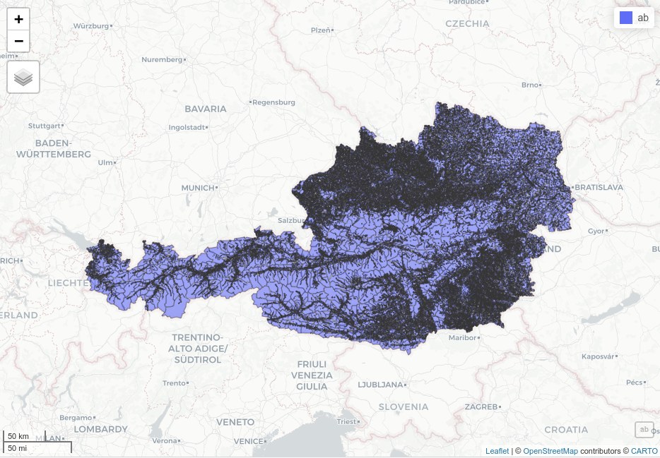
Here is the result: enter image description here
1
  • Hi Cesar, I just wanted to thank you because indeed this parallel processing way saved me a lot of time! Commented Jun 2 at 20:34
0

By just changing the geometry to polygons before the intersection you'll gain a lot of time in the processing.

You can use st_cast for both shapefiles

st_cast(mynameshape, "POLYGON")

Your Answer

By clicking “Post Your Answer”, you agree to our terms of service and acknowledge you have read our privacy policy.

Not the answer you're looking for? Browse other questions tagged or ask your own question.