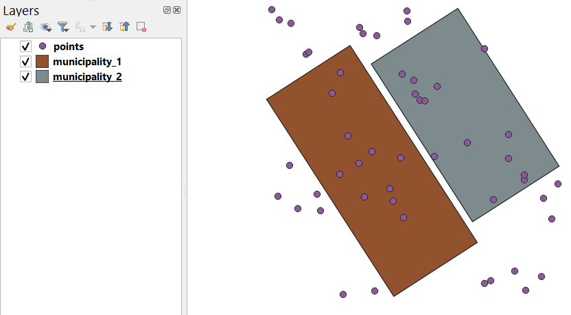
Using a set of the following features

and the code below
import processing
import time

start_tot = time.time()

path = 'C:/Users/Taras/Downloads/data/'

ext = ".shp"

municipalities = ["municipality_1", "municipality_2"]

layer = "points"

for value in municipalities:

    start = time.time()
    input_layer = path+layer+ext
    input_municipality = path+value+ext

    output_layer = path+layer+"_"+value+ext

    processing.run("native:clip", {'INPUT':input_layer, 'OVERLAY':input_municipality, 'DISSOLVE': False, 'OUTPUT':output_layer})

    iface.addVectorLayer(output_layer, '', 'ogr')

    end = time.time()
    print("Elapsed time for", value, ":", end-start, "seconds.")

end_tot = time.time()
print()
print("Total time elapsed:", (end_tot-start_tot)/60, "minutes.")
I could recreate the same error
Traceback (most recent call last):
  File "D:\Software\apps\Python39\lib\code.py", line 90, in runcode
    exec(code, self.locals)
  File "<input>", line 1, in <module>
  File "<string>", line 22, in <module>
  File "D:\Software/apps/qgis/./python/plugins\processing\tools\general.py", line 108, in run
    return Processing.runAlgorithm(algOrName, parameters, onFinish, feedback, context)
  File "D:\Software/apps/qgis/./python/plugins\processing\core\Processing.py", line 187, in runAlgorithm
    ret, results = execute(alg, parameters, context, feedback, catch_exceptions=False)
  File "D:\Software/apps/qgis/./python/plugins\processing\gui\AlgorithmExecutor.py", line 72, in execute
    results, ok = alg.run(parameters, context, feedback, {}, False)
_core.QgsProcessingException: Could not write feature into OUTPUT
The problem is about:
Feature creation error (OGR error: Attempt to write non-point
(MULTIPOINT) geometry to point shapefile.)
The same error can be discovered when writing the temporal output to a shapefile:
alg_params = {
    'INPUT': input_layer,
    'OVERLAY': input_municipality,
    'OUTPUT': 'memory:'
    }

res = processing.run("native:clip", alg_params)['OUTPUT']

save_options = QgsVectorFileWriter.SaveVectorOptions()
save_options.driverName = "ESRI Shapefile"
save_options.fileEncoding = "UTF-8"
transform_context = QgsProject.instance().transformContext()
error = QgsVectorFileWriter.writeAsVectorFormatV3(res, output_layer, transform_context, save_options)

if error[0] == QgsVectorFileWriter.NoError:
    print("success!")
else:
    print(error)
that will lead to this error:
(7,
'Feature write errors:\nFeature creation error (OGR error: Attempt to write non-point (MULTIPOINT) geometry to point shapefile.)...
\nOnly 0 of 13 features written.', 'C:\\Users\\Taras\\Downloads\\data\\points_municipality_1.shp', 'points_municipality_1')
There are several ideas on how to overcome this error:
Using the GeoPackage as an output file format
output_layer = join(path, layer + "_" + value + '.gpkg')
Applying additionally the "Multipart to singleparts" geoalgorithm
alg_params = {
    'INPUT' : previous_output,
    'OUTPUT' : output_layer
    }
processing.run("native:multiparttosingleparts", alg_params)
There are also several relevant suggestions:
There is no need to have the 'DISSOLVE' parameter. Check the geoalgorithm with processing.algorithmHelp("native:clip"):
Clip (native:clip)

This algorithm clips a vector layer using the features of an additional polygon layer. Only the parts of the features in the Input layer that fall within the polygons of the Overlay layer will be added to the resulting layer.

The attributes of the features are not modified, although properties such as the area or length of the features will be modified by the clipping operation. If such properties are stored as attributes, those attributes will have to be manually updated.

----------------
Input parameters
----------------

INPUT: Input layer

    Parameter type: QgsProcessingParameterFeatureSource

    Accepted data types:
        - str: layer ID
        - str: layer name
        - str: layer source
        - QgsProcessingFeatureSourceDefinition
        - QgsProperty
        - QgsVectorLayer

OVERLAY: Overlay layer

    Parameter type: QgsProcessingParameterFeatureSource

    Accepted data types:
        - str: layer ID
        - str: layer name
        - str: layer source
        - QgsProcessingFeatureSourceDefinition
        - QgsProperty
        - QgsVectorLayer

OUTPUT: Clipped

    Parameter type: QgsProcessingParameterFeatureSink

    Accepted data types:
        - str: destination vector file, e.g. 'd:/test.shp'
        - str: 'memory:' to store result in temporary memory layer
        - str: using vector provider ID prefix and destination URI, e.g. 'postgres:…' to store result in PostGIS table
        - QgsProcessingOutputLayerDefinition
        - QgsProperty

----------------
Outputs
----------------

OUTPUT:  <QgsProcessingOutputVectorLayer>
    Clipped
Applying the Python's native library os.path to handle file paths and names
Working with the try except block is also a common Python practice
try:
    processing.run("native:clip", alg_params)
except QgsProcessingException as err:
    print(err)
Last but not least make use of the spatial index for the input layer
So, after all, your code may look as follows:
import time
import processing
from os.path import join, normpath

start_tot = time.time()

path = normpath('C://Users//Taras//Downloads//data//')
layer = "points"
ext = ".shp"
input_layer = join(path, layer + ext)

municipalities = ["municipality_1", "municipality_2"]

for value in municipalities:

    start = time.time()

    input_municipality = join(path, value + ext)

    alg_params1 = {
        'INPUT' : input_layer,
        'OVERLAY' : input_municipality,
        'OUTPUT' : 'memory:'
        }

    res1 = processing.run("native:clip", alg_params1)['OUTPUT']

    output_layer = join(path, layer + "_" + value + ext)

    alg_params2 = {
        'INPUT' : res1,
        'OUTPUT' : output_layer
        }

    res2 = processing.run("native:multiparttosingleparts", alg_params2)

    iface.addVectorLayer(output_layer, '', 'ogr')

    end = time.time()
    print("Elapsed time for", value, ":", end-start, "seconds.")

end_tot = time.time()
print()
print("Total time elapsed:", (end_tot-start_tot)/60, "minutes.")
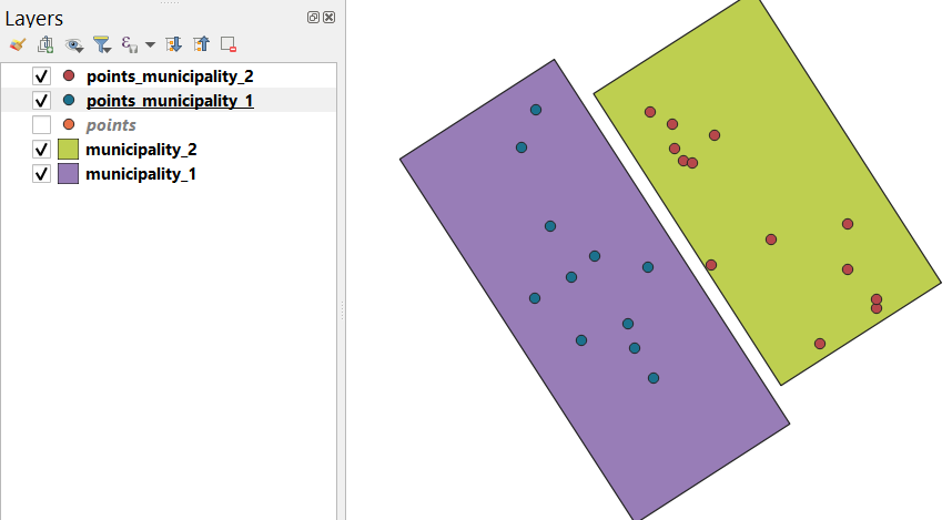
and get the output like this:

References:


all_rs_400kvand thepoint layer? Any changes in CRS between the layers? Are both layers loaded in QGIS (edit mode?)? Could it be write protected ?