I’m working on a viewshed analysis for an ADLS tower. Basically, I need to ensure that aircraft at various altitudes are visible to the tower. I have an ADLS tower with elevation and height values, and a DEM. I first computed different viewsheds at varying altitudes using the ArcGIS Pro visibility tool. All the altitudes were computed AGL or above ground level. I’ve now been asked to compute a viewshed at an altitude AMSL (above mean sea level). I know this will require some extra steps as the altitude will be fixed, vs offset from the DEM surface. The visibility tool only has fields that are offset from the surface. Anyone have any experience with this or thoughts on how I might go about it?
-
I am trying to follow what you are looking to do in your example. Could you please elaborate on what steps you have taken already and what you are looking to do? I am getting confused with the switch from AGL to AMSL.– Keagan AllanCommented Aug 10, 2023 at 22:41
-
@KeaganAllan Basically, the FAA requested a viewshed for the tower at 1500 ft AMSL. My understanding is that we need to confirm the visibility of an aircraft traveling at a elevation of 1500 ft amsl to the ADLS tower. I'm unsure how to go about this because the ArcGIS Pro visibility tool only gives me options to input the elevation as offset from a surface. The 1500ft AMSL would have a variable offset from the ground surface.– user228996Commented Aug 11, 2023 at 20:09
-
Do you have a surface representing AMSL? The one time I worked with AMSL, we used an online site and typed in lat-long for our points to get the values. AMSL is very variable. We didn't try super hard, but we could not find a surface/DEM for AMSL.– danakCommented Aug 14, 2023 at 15:34
-
Could you clarify that MSL vertical datum requirement with the FAA? Very odd that the FAA would not request elevations above the North American Vertical Datum of 1988 (NAVD88) which would be the vertical datum for 3DEP surface models available via the National Map.– GBGCommented Aug 21, 2023 at 16:34
1 Answer
The Viewshed Analysis tool includes an optional output which is the height above ground for the un-visible areas to be visible to your observer point.
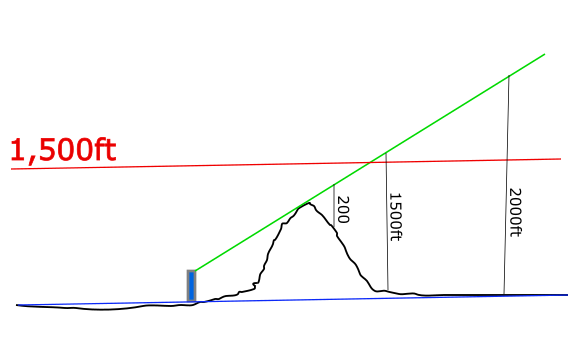
Consider this graphic that shows 0 elevation as a blue line, the 1,500ft elevation line in red, and the view areas as a green line.
For those un-visible areas at one point you need to be 200 feet above ground to see the tower, at another you need to be 1,500 feet above ground to see the tower, and the third you need to be at 2,000 feet above ground to see the tower.
Subtract the resulting height above ground surface from the surface model. Any location that is less than 1,500 is visible to your tower at 1,500', and a value that is greater than 1,500 is not visible from 1500'.
Reclassify the results to 1 (is visible from 1,500') or 0 (is not visible from 1,500').
As I mentioned in the comments I am almost positive the FAA is referring to NAVD88 heights which would be the elevations expressed in the 3DEP data. If for some odd reason the FAA want tidal datums the best you could hope for would be old USGS 10 meter DEM data which use NGVD29.

