Short answer
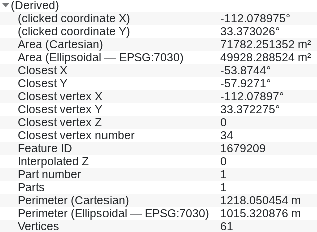
Reproject to a CRS that is appropriate for measurements like local UTM zone. A good indicator that you use a CRS that is appropriate for measurements is if values for cartesian and ellipsoidal measurements are very similar. If this is not the case, then ellipsoidal measurement is closer to the reality.
How to reproject and what to avoid
Don't change project CRS. This only changes how the map is presented on the map canvas. You should reproject (not change!) the layer CRS: either use Menu Processing > Toolbox > Reproject layer or export/save the layer with a new CRS definition.
By the way: EPSG:3070 stands not for a CRS, but for the WGS 84 ellipsoid - the one used for ellipsoidal measurements. Depending on which CRS you use, other ellipsoids might be used. WGS 84 / EPSG:3070 is used for CRS EPSG:4326 as well as EPSG:3857 (and others), so ellipsoidal measurements based on these CRS should return the same values.
Background
Your layer is in EPSG:3857 (Web Mercator) and like this, this CRS is used for cartesian measurements. However, cartesian area returns completely wrong results if you don't use a CRS approriate for measurements, like e.g. a national grid or local UTM zone. The CRS you use for your layer, EPSG:3857, is based on a Mercator projection. Mercator projections are known to heavily distort size, so cartesian measurements measures the distorted area, not the real area.
Ellipsoidal measurements are closer to the reality as they always consider Earth's curved surface, based on the ellipsoid defined in the CRS.
Don't confuse matters: QGIS reprojects "on the fly" to locate layers in different CRS correctly on the map canvas. This is for visualization. For geoprocessing, measurements etc. however, you should not rely on this as the algorithms calculate using the values they get from the layer.

