13

I'm fairly new at GIS, but I've run into a problem with a projection of a world map. I have a shapefile of all countries I downloaded from Natural Earth. After projecting it into a orthographic as suggested in How do I project a Azimuthal Equidistant global map into a circle in QGIS?, I changed the lat/long so that the Atlantic would be somewhat in the center.

However, after changing it, the United States, Mexico and Canada disappear from the map, as you can see here: enter image description here

When I reproject the map to a long over the US, the polygons appear again.

Any suggestions?

4
  • 2
    Note that Russia, Kazakhstan, Iran, and a few smaller Near Eastern countries also do not appear, nor does any part of Antarctica. Evidently the software is not correctly clipping the polygons that are only partially hidden.
    – whuber
    Commented Aug 30, 2013 at 18:00
  • Which version of Qgis? Can you also provide a direct link to the layer that you have downloaded from Natural Earth? Then we can try to reproduce your problem. Thanks! Commented Aug 31, 2013 at 19:58
  • That is a very strange reprojection. Provide the link so we can download and check it out.
    – Ger
    Commented Sep 2, 2013 at 9:29
  • Ok i looked into it and deleted my previous comment as they are clearly there. what is appears that in a CRS of WGS 84 it is projected as being on a globe, hence half the world is not visible, in a CRS of WGS84 Pseudo Mercator It appears correctly. as with any other CRS, showing all landmasses.
    – Ger
    Commented Sep 2, 2013 at 10:05

2 Answers 2

12

The simple reason why QGIS can not draw these polygons is because some of the vertices are on the backside of the globe, and QGIS can not draw a closed polygon with the rest. The GDAL ogr2ogr function in the background is programmed to kick off the whole feature when such an error occurs.

So you have two solutions:


Solution 1: Clip your polygons to the hemisphere

You need Numerical Digitize and CAD Tools plugin for that.

  • Set the project CRS to ortho projection
  • create a new point layer in the same projection
  • with the Numerical Digitize plugin, create the following points:
x y
6370000 0
0 6370000
-6370000 0
0 -6370000

(should also work with Add delimited text layer)

  • enable snapping on the point layer
  • with CAD Tools, select the first three points and create an arc from them
  • do the same for points 3 - 4 - 1 for the southern hemisphere
  • change project CRS to WGS84
  • Save the CAD layer as WGS84 and add that to the canvas
  • Save your boundary layer also as WGS84 and add it to the canvas
  • convert the CAD lines to a new polygon layer
  • remove all except the polygon layers
  • clip the world boundaries to the CAD polygon layer
  • set project CRS back to ortho

You should get this picture: world vector in ortho projection
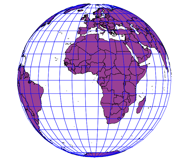

Solution 2: Convert your vector data to raster

  • in Settings, disable on-the-fly-reprojection
  • Save your boundary layer as WGS84 and add that to the canvas
  • Use Raster -> Convert -> Rasterize on the WGS84 layer select x=360 and y=170 as dimensions for the raster (or n*360 and n*170)
  • Use Raster -> Projection -> Reproject to the ortho projection under another name and add it to the canvas. You will get some errors, but the rest of the raster will do. Don't bother that you see a grey rectangle
  • Rightclick on the raster layer -> Properties, Style tab
  • choose pseudo colours
  • in transparency tab, choose 0 for 100% transparency
  • Remove the first raster
  • set project CRS to ortho

you should see the follwing picture: enter image description here
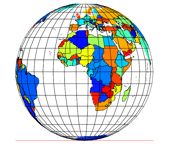
The same method works with rasters, as you can see in my avatar picture ;-)


EDIT

To get a nice ortho projection centered on a point not on the equator, do the clipping in an aeqd projection with the same parameters as the ortho. You will get this result:
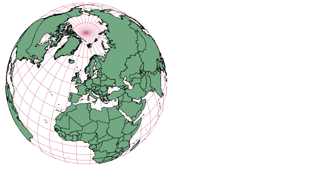
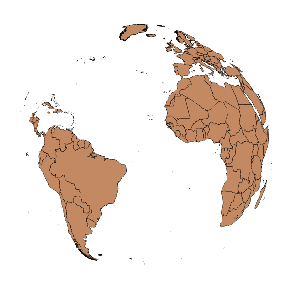
enter image description here

4
  • Does the first approach need to be adapted when the orthographic projection includes one of the poles (like in your avatar picture)? I run into problems when projecting the CAD layer to WGS84 in that case, since the resulting polygon doesn't cover the pole
    – Jake
    Commented Nov 22, 2013 at 16:11
  • You are right. Using an aeqd projection instead of WGS84 for the clipping works for this case. Clipping on a sphere seems to be easier than the ellipsoid.
    – AndreJ
    Commented Nov 23, 2013 at 5:30
  • Ah yes, that's a good idea! However, it still doesn't seem to be the silver bullet: I tried using that approach with the Natural Earth 1:110M land dataset with a projection centered on 30°N, 110°E, and run into trouble when projecting the dataset to aeqd: The large polygons flip over and ruin the clipping. Any ideas?
    – Jake
    Commented Nov 23, 2013 at 20:16
  • The antipodial point of the aeqd must lay in the sea to avoid the artefacts. Te aeqd center does not have to be the same point as for the final ortho, but must lay within the clipping circle.
    – AndreJ
    Commented Nov 24, 2013 at 10:12
0

See comment above, they have simply gone to the other side of the globe. the polygons of the countries are still there but are not visible unless the globe is spun. i am not sure on how you rotate the globe in this circumatances and mapping is generally 2 dimensional (countours etc excluding).

I would set your CRS to the country in which you want to overlay data. For instance i would use the Irish grid or OSGB grid, or as stated above the WGS84 Pseudo Mercator.

7
  • 3
    Jessica wanted a picture of the whole globe as a circle. The projections you propose don't do that.
    – AndreJ
    Commented Sep 2, 2013 at 17:57
  • down vote is a bit harsh if you ask me.
    – Ger
    Commented Sep 4, 2013 at 8:59
  • That was not by me ...
    – AndreJ
    Commented Sep 4, 2013 at 9:45
  • 1
    Cool. I just dont get why people down vote on a suggestion. I have a bee in my bonnet about it and that is all.
    – Ger
    Commented Sep 4, 2013 at 9:54
  • 4
    A down-vote should not be taken personally. The entire SE network relies on up- and down-votes to float the best answers to the top of a question. I down-voted the answer because "set CRS to country...overlay data" ignores the OP's stated desire to keep the Atlantic Ocean centered on the map.
    – user3461
    Commented Sep 7, 2013 at 12:16

Your Answer

By clicking “Post Your Answer”, you agree to our terms of service and acknowledge you have read our privacy policy.

Not the answer you're looking for? Browse other questions tagged or ask your own question.