2

I mostly use ArcGIS at work and am digging into QGIS at home and for my business. At work we are phasing out the use of shapefiles and moving towards geodatabases. So I am thinking I should look into this at home and for the business. having very limited knowledge of this, this is what I assume I need to do.

  1. Install Postgresql on my Ubuntu Server
  2. Install PostGIS on my Ubuntu Server
  3. Connect to PostGIS from my Windows Machine that currently has QGIS 2.0 installed.

Once this is done I have to make the connection to the server, then figure out how to turn some of my existing shapefile data into a database.

So here is my question:

Does the above process sound correct and are there any step by step resources for the beginner to set implement this process?

Be gentle I have no formal training in GIS, its all on the fly.

3

2 Answers 2

5

Any specific reason you don't want to test it all on your windows machine first? Get accustomed and then look into setting up a server?

Anyway, the workflow you posted is fine.

The detailed installation procedure varies a little from Ubuntu version to Ubuntu version. You'll find pointers for example in Install PostGIS on Ubuntu 12.04 or Unable to install the PostGIS extension to PostgreSQL on Ubuntu 12.04 LTS

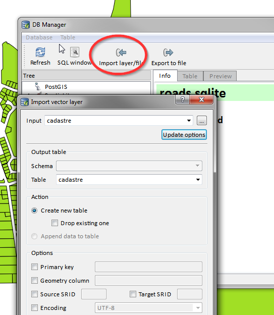
You can load Shapefiles into PostGIS using QGIS DB Manager. It has an import tool. See for example Exporting shapefile to PostGIS database in QGIS

enter image description here

3
  • I never thought of setting it up locally for trial and error. I guess the thought would be shy do it twice. Is it that difficult to get it up on a server?
    – LandArch
    Commented Oct 24, 2013 at 19:38
  • @LandArch It's just that installation on windows is super simple and you can be rolling in ten minutes. But it's not a big deal on Ubuntu either.
    – underdark
    Commented Oct 25, 2013 at 11:22
  • I got here while looking for the Ubuntu corrispective of windows' "postGIS shapefile Import/Export Manager". So in Ubuntu we have to open QGIS and use DB Manager. Very useful, thanks!
    – Tms91
    Commented Jan 30, 2023 at 23:49
3

Consider using SpatiaLite

PostGIS/PostgreSQL is arguably the most powerful and flexible geospatial database solution, albeit a little cumbersome for the beginner to set up, configure and learn. Some of the advantages of having your geospatial data in PostgreSQL with PostGIS is all of the spatial operation functions it makes available to use in your SQL queries and the fast response of those queries.

The only aspects of a PostGIS/PostgreSQL setup that may be considered a disadvantage, depending upon your workflow, is its lack of easy portability and the general complexity of managing a database server. In many workflow instances, i.e. a single user, PostGIS/PostgreSQL is overkill.

There is another open source solution for geospatial databases, that offers many of the same features of PostGIS/PostgreSQL, plus portability and a file-based architecture (instead of server/client): SpatiaLite, which is built upon SQLite. With SpatiaLite 4.x users now have many of the same PostGIS-like geospatial functions available to them as well.

You can easily convert shapefiles to SpatiaLite database files via the command line, via the spatialite-gui application, or by right-clicking on a QGIS layer and choosing Save As... (QGIS SpatiaLite layer user docs).

Depending upon your workflow this may be a good final solution or a decent stepping stone towards an eventually more robust setup (e.g. PostGIS/PostgreSQL). There is also a new dynamic extension for SpatiaLite called VirtualPG that allows for direct connections between SpatiaLite and PostGIS/PostgreSQL to help with data exchange.

Your Answer

By clicking “Post Your Answer”, you agree to our terms of service and acknowledge you have read our privacy policy.

Not the answer you're looking for? Browse other questions tagged or ask your own question.