The County of Napa, California, uses a projection "NAD_1983_StatePlane_California_II_FIPS_0402_Feet"; for example their roads.prj file has:
PROJCS["NAD_1983_StatePlane_California_II_FIPS_0402_Feet",GEOGCS["GCS_North_American_1983",DATUM["D_North_American_1983",SPHEROID["GRS_1980",6378137.0,298.257222101]],PRIMEM["Greenwich",0.0],UNIT["Degree",0.0174532925199433]],PROJECTION["Lambert_Conformal_Conic"],PARAMETER["False_Easting",6561666.666666666],PARAMETER["False_Northing",1640416.666666667],PARAMETER["Central_Meridian",-122.0],PARAMETER["Standard_Parallel_1",38.33333333333334],PARAMETER["Standard_Parallel_2",39.83333333333334],PARAMETER["Latitude_Of_Origin",37.66666666666666],UNIT["Foot_US",0.3048006096012192]]
I looked this projection up at spatialreference.org and fount a match to this: http://spatialreference.org/ref/esri/102642/ There is an INSERT statement provided:
INSERT into spatial_ref_sys (srid, auth_name, auth_srid, proj4text, srtext) values ( 9102642, 'esri', 102642, '+proj=lcc +lat_1=38.33333333333334 +lat_2=39.83333333333334 +lat_0=37.66666666666666 +lon_0=-122 +x_0=2000000 +y_0=500000.0000000002 +ellps=GRS80 +datum=NAD83 +to_meter=0.3048006096012192 +no_defs ', 'PROJCS["NAD_1983_StatePlane_California_II_FIPS_0402_Feet",GEOGCS["GCS_North_American_1983",DATUM["North_American_Datum_1983",SPHEROID["GRS_1980",6378137,298.257222101]],PRIMEM["Greenwich",0],UNIT["Degree",0.017453292519943295]],PROJECTION["Lambert_Conformal_Conic_2SP"],PARAMETER["False_Easting",6561666.666666666],PARAMETER["False_Northing",1640416.666666667],PARAMETER["Central_Meridian",-122],PARAMETER["Standard_Parallel_1",38.33333333333334],PARAMETER["Standard_Parallel_2",39.83333333333334],PARAMETER["Latitude_Of_Origin",37.66666666666666],UNIT["Foot_US",0.30480060960121924],AUTHORITY["EPSG","102642"]]'); [inserted new line for clarity]
As you can see the values for the column "srid" is "9102642".
The problem is that the table "spatial_ref_sys" prohibits a value that exceeds 998999. Here is the table SQL showing the constraint:
CREATE TABLE spatial_ref_sys ( srid integer NOT NULL, auth_name character varying(256), auth_srid integer, srtext character varying(2048), proj4text character varying(2048), CONSTRAINT spatial_ref_sys_pkey PRIMARY KEY (srid), CONSTRAINT spatial_ref_sys_srid_check CHECK (srid > 0 AND srid <= 998999) )
The constraint is the "<= 998999" and since the INSERT statement's srid value is 9102642, the INSERT fails.
So I checked to see if the srid 102642 was taken and it was not:
select srid from spatial_ref_sys where srid = 102642;
I then modified the insert statement by removing the first digit "9" from the srid value and then performing the insert.
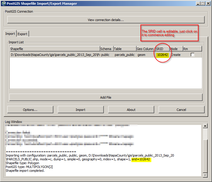
I then proceeded to import a shapefile using the PostGIS Shapefile Import/Export Manager (v.2.1.0) and specified the srid to the column I had created:

My questions are:
1) why would the INSERT statement for PostGIS be in excess of 998999 when PostGIS's table has a constraint to limit srids?
2) Will the work-around I used cause any problems or violate some "plan"?
3) If the first digit "9" is an error, what is the best way to report such at spatialreference.org? Their website does not seem to provide for error reporting.
