3

I am using a DEM and using menu Raster > Terrain analysis > Hillshade. When I type a simple output file name "MyHillshade" and then click "OK", I get a two-part error message that says:

"GDAL provider: Cannot open GDAL dataset MyHillshade.tif: `MyHillshade.tif' does not exist in the file system, and is not recognised as a supported dataset name.

"Raster layer: Provider is not valid (provider: gdal, URI: MyHillshade.tif"

How can I repair this situation?

1
  • The message error says only that GDAL cannot find MyHillshade.tif in the file system. So, what is the path of your resulting layer ?
    – gene
    Commented Dec 14, 2013 at 10:40

1 Answer 1

4

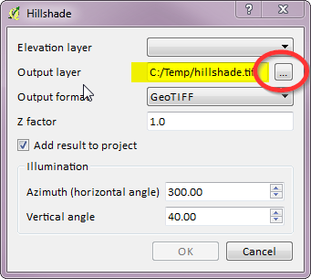
Make sure you set the full path. This error seems to occur when you only give gdal the name of the file.

enter image description here

1
  • I guess that Elevation layer should be set too.
    – AndreJ
    Commented Dec 14, 2013 at 16:07

Your Answer

By clicking “Post Your Answer”, you agree to our terms of service and acknowledge you have read our privacy policy.

Not the answer you're looking for? Browse other questions tagged or ask your own question.