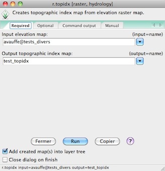
1) First, you need to consult the r.topidx command of GRASS GIS:
With GRASS GIS:

The command is
r.topidx input=avauffe@tests_divers output=test_topixd
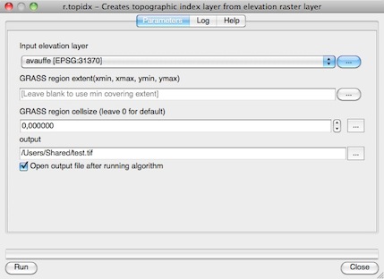
2) same with QGIS

The processing log
ALGORITHM|Thu Jun 26 2014 20:45:33|processing.runalg("grass:r.topidx","/Users/Shared/avauffe.tif","202086.577,205625.414407,88411.048,90534.3504441",0,"/Users/Shared/test.tif")
From the help:
input = /Users/Shared/avauffe.tif"
GRASS_REGION_PARAMETER = "202086.577,205625.414407,88411.048,90534.3504441"
GRASS_REGION_CELLSIZE_PARAMETER = 0
Output topographic index layer =  /Users/Shared/test.tif"
If there is a problem, you will get the error message "Oops..."
To check:
When you use a GRASS command from processing, the processing Python module create first a batch file with the command, named "grass_batch_job.sh" (Linux, Mac OS X) or "grass_script.bat" (Windows) in the folder .../.qgis2/processing: :

Then it execute this command with the Python module subprocess ((Python script .../plugins/processing/algs/grass/GrassUtils.py)
What is the content of your batch file ?
The batch file with v.voronoi:
g.proj -c proj4="+proj=utm +zone=30 +ellps=intl +towgs84=-87,-98,-121,0,0,0,0 +units=m +no_defs"
v.in.ogr min_area=0.0001 snap=-1 dsn="/Users/Shared/telechargement/30_06_14/qgis-mac-2.4/QGIS_2.3-dev_SnoLeo.app/Contents/MacOS/../Resources/python/plugins/processing/tests/data" layer=points output=tmp1403985550269 --overwrite -o
g.region n=4458983.8488 s=4458921.97814 e=270855.745301 w=270778.60198 res=1
v.voronoi input=tmp1403985550269 output=output4973a4a8d42444ce8ac8de404e4b13b7   --overwrite
v.out.ogr -s -c -e -z input=output4973a4a8d42444ce8ac8de404e4b13b7 dsn="/var/folders/vu/vu099NovH-KZpE5TEa83BU+++TI/-Tmp-/processing/1b556bdecead4a11a31da2fc029aa67d" format=ESRI_Shapefile olayer=output type=auto
exit
comes from the script GrassUtils.py (line 353-392) to check if GRASS GIS is installed:
    def checkGrassIsInstalled(ignorePreviousState=False):
    if isWindows():
        path = GrassUtils.grassPath()
        if path == '':
            return 'GRASS folder is not configured.\nPlease configure \
                    it before running GRASS algorithms.'
        cmdpath = os.path.join(path, 'bin', 'r.out.gdal.exe')
        if not os.path.exists(cmdpath):
            return 'The specified GRASS folder does not contain a valid \
                    set of GRASS modules.\n' \
                    + 'Please, go to the Processing settings dialog, and \
                    check that the GRASS\n' \
                    + 'folder is correctly configured'

    if not ignorePreviousState:
        if GrassUtils.isGrassInstalled:
            return
    try:
        from processing import runalg
        result = runalg(
            'grass:v.voronoi',
            points(),
            False,
            False,
            '270778.60198,270855.745301,4458921.97814,4458983.8488',
            -1,
            0.0001,
            0,
            None,
            )
        if not os.path.exists(result['output']):
            return 'It seems that GRASS is not correctly installed and \
                configured in your system.\nPlease install it before \
                running GRASS algorithms.'
    except:
        s = traceback.format_exc()
        return 'Error while checking GRASS installation. GRASS might not \
            be correctly configured.\n' + s

    GrassUtils.isGrassInstalled = True
This function is called when there is a problem and the command cannot be executed -> your grass_script.bat
GRASS seems to be correctly installed and configured
A solution ?
Use GRASS GIS directly (an not GRASS GIS from QGIS via processing) or the GRASS plugin


