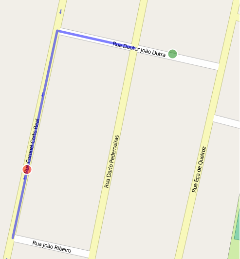
Using localhost page generated by osm2po roteamente noticed that the link is made to link even disabling snapping.

Logically thought to create more nodes in the network, but how can I do this without losing the topology of the data?
I had the same problem few weeks ago and solved it by manually drawing lines from nearest node. I don't know if it's one and only resolution, it's quite hard and tricky but its working quite good.
Firstly I'm selecting start edge, stop edge and result (path from routing) into record variables, then doing some post-procesing:
Cut the result road if it's near start and end point
if st_within(start_edge.geom_way, result.geom) then
  result.geom = ST_Difference(result.geom, start_edge.geom_way);
  result.km = result.km - start_edge.km;
  result.cost = result.cost - start_edge.cost;
end if;

if st_within(stop_edge.geom_way, result.geom) then
  result.geom = ST_Difference(result.geom, stop_edge.geom_way);
  result.km = result.km - stop_edge.km;
  result.cost = result.cost - stop_edge.cost;
end if;
Draw missing pieces by splitting start_edge and stop_edge. Unfortunately PostGIS is having troubles with splitting line by a point (case of rounding), so you have to draw the line from starting point intersecting cutting edge (I'm drawing line from point of start to point that is in direction of nearest point on line and 2xdistance)
select foo.geom
from (
select (st_dump(
   st_split(start_edge.geom_way,
   st_makeline(ST_setsrid(ST_makepoint(start_x_4326,start_y_4326),4326),
   (st_project(
     ST_setsrid(ST_makepoint(start_x_4326,start_y_4326),4326)::geography,
     ST_distance(ST_setsrid(ST_makepoint(start_x_4326,start_y_4326),4326)::geography,st_closestpoint(start_edge.geom_way,ST_setsrid(ST_makepoint(start_x_4326,start_y_4326),4326)))*2,
     ST_azimuth(ST_setsrid(ST_makepoint(start_x_4326,start_y_4326),4326)::geography,st_closestpoint(start_edge.geom_way,ST_setsrid(ST_makepoint(start_x_4326,start_y_4326),4326)))))::geometry)))).geom as geom) as foo
where st_touches(foo.geom, result.geom)
into add_start_edge;


select foo.geom
from (
  select (st_dump(
   st_split(stop_edge.geom_way,
     st_makeline(ST_setsrid(ST_makepoint(stop_x_4326,stop_y_4326),4326),
   (st_project(
     ST_setsrid(ST_makepoint(stop_x_4326,stop_y_4326),4326)::geography,
     ST_distance(ST_setsrid(ST_makepoint(stop_x_4326,stop_y_4326),4326)::geography,st_closestpoint(stop_edge.geom_way,ST_setsrid(ST_makepoint(stop_x_4326,stop_y_4326),4326)))*2,
     ST_azimuth(ST_setsrid(ST_makepoint(stop_x_4326,stop_y_4326),4326)::geography,st_closestpoint(stop_edge.geom_way,ST_setsrid(ST_makepoint(stop_x_4326,stop_y_4326),4326)))))::geometry)))).geom as geom) as foo
  where st_touches(foo.geom, result.geom)
into add_stop_edge;
Now all you have to do is add this lines to result
result.km = result.km + (start_edge.km * (ST_Length(add_start_edge) / ST_Length(start_edge.geom_way)));
result.cost = result.cost + (start_edge.cost * (ST_Length(add_start_edge) / ST_Length(start_edge.geom_way)));
result.geom = ST_Union(result.geom, add_start_edge);

result.km = result.km + (stop_edge.km * (ST_Length(add_stop_edge) / ST_Length(stop_edge.geom_way)));
result.cost = result.cost + (stop_edge.cost * (ST_Length(add_stop_edge) / ST_Length(stop_edge.geom_way)));
result.geom = ST_Union(result.geom, add_stop_edge);
And return result from procedure
return query select result.km, result.cost, ST_Transform(result.geom, epsg);
PS. Keep in mind that if closest edge of your starting or target point is one-way not always the closest vertex of an edge is good point to paste into routing query. In your example if Riberio would be shortest your routing will end on Real-Riberio crossing and then you have to drive counter the road direction... :)
Putting extra nodes to the static graph is no good idea. One reason is that the graph may be shared by parallel routing request. Another is that the graph will grow with each request.
One solution is to overlay the graph with virtual edges and nodes and to write a router which is able to distiguish between them. This is the technique used by osm2po.
Disabling snapping in osm2po's WebTestUI (screenshot above) only affects some routers - not the DefaultRouter which is a simple vertex-based Dijkstra/AStar. In order to see a correct picture, enable one of the "Ovl.."-routers in the config file.