I have problems projecting MODIS Ice Sea Temperature (IST) products to EPSG:3031 (Antartic Polar Stereographic) using gdalwarp.
The product I'm working with is MOD29E1D, documented here, p33:
The global daily level-3 sea ice product containing sea ice extent and ice surface temperature (IST) is in EASE-Grid polar projection at approximately 4 km spatial resolution.
For reproducibility, the file I'm trying to process is located here and named MOD29E1D.A2010357.005.2010358085416.hdf.
I'm interested in the fourth dataset, i.e. the ice sea temperature for the South Pole. Here is the gdalinfo output for this dataset:
$ gdalinfo -stats 'HDF4_EOS:EOS_GRID:"MOD29E1D.A2010357.005.2010358085416.hdf":MOD_Grid_Seaice_4km_South:Ice_Surface_Temperature_SP'
Driver: HDF4Image/HDF4 Dataset
Files: MOD29E1D.A2010357.005.2010358085416.hdf
       MOD29E1D.A2010357.005.2010358085416.hdf.aux.xml
Size is 4501, 4501
Coordinate System is:
PROJCS["unnamed",
    GEOGCS["Unknown datum based upon the Clarke 1866 ellipsoid",
        DATUM["Not specified (based on Clarke 1866 spheroid)",
            SPHEROID["Clarke 1866",6378206.4,294.9786982139006,
                AUTHORITY["EPSG","7008"]]],
        PRIMEM["Greenwich",0],
        UNIT["degree",0.0174532925199433]],
    PROJECTION["Lambert_Azimuthal_Equal_Area"],
    PARAMETER["latitude_of_center",-5156620156.177409],
    PARAMETER["longitude_of_center",0],
    PARAMETER["false_easting",0],
    PARAMETER["false_northing",0],
    UNIT["Meter",1]]
Origin = (-9026314.402000000700355,9026314.402000000700355)
Pixel Size = (4010.804000000000087,-4010.804000000000087)
  SHORTNAME=MOD29E1D
  SOUTHBOUNDINGCOORDINATE=-90.0
  SPSOPARAMETERS=none
  units=degree_Kelvin
  valid_range=22320, 31320
  VERSIONID=5
  WESTBOUNDINGCOORDINATE=-180.0
Corner Coordinates:
Upper Left  (-9026314.402, 9026314.402) (-2147483648d-2147483648'  nan"E,-2147483648d-2147483648'  nan"N)
Lower Left  (-9026314.402,-9026314.402) (-2147483648d-2147483648'  nan"E,-2147483648d-2147483648'  nan"N)
Upper Right ( 9026314.402, 9026314.402) (-2147483648d-2147483648'  nan"E,-2147483648d-2147483648'  nan"N)
Lower Right ( 9026314.402,-9026314.402) (-2147483648d-2147483648'  nan"E,-2147483648d-2147483648'  nan"N)
Center      (   0.0000000,   0.0000000) (  0d 0' 0.01"E,Invalid angle)
Band 1 Block=4501x222 Type=UInt16, ColorInterp=Gray
  Description = Estimated sea ice surface temperature 4 km South Pole grid
  Min=0.000 Max=29668.000
  Minimum=0.000, Maximum=29668.000, Mean=2238.933, StdDev=4362.846
  NoData Value=7
  Unit Type: degree_Kelvin
  Offset: 0,   Scale:0.01
  Metadata:
    STATISTICS_MAXIMUM=29668
    STATISTICS_MEAN=2238.9331848594
    STATISTICS_MINIMUM=0
    STATISTICS_STDDEV=4362.8462148872
The output of gdalsrsinfo gives us the proj.4 string for this dataset:
$ gdalsrsinfo 'HDF4_EOS:EOS_GRID:"MOD29E1D.A2010357.005.2010358085416.hdf":MOD_Grid_Seaice_4km_South:Ice_Surface_Temperature_SP'
PROJ.4 : '+proj=laea +lat_0=-5156620156.177409 +lon_0=0 +x_0=0 +y_0=0 +ellps=clrk66 +units=m +no_defs '

OGC WKT :
PROJCS["unnamed",
    GEOGCS["Unknown datum based upon the Clarke 1866 ellipsoid",
        DATUM["Not specified (based on Clarke 1866 spheroid)",
            SPHEROID["Clarke 1866",6378206.4,294.9786982139006,
                AUTHORITY["EPSG","7008"]]],
        PRIMEM["Greenwich",0],
        UNIT["degree",0.0174532925199433]],
    PROJECTION["Lambert_Azimuthal_Equal_Area"],
    PARAMETER["latitude_of_center",-5156620156.177409],
    PARAMETER["longitude_of_center",0],
    PARAMETER["false_easting",0],
    PARAMETER["false_northing",0],
    UNIT["Meter",1]]
From there, I can use gdalwarp to reproject the data layer:
$ gdalwarp -s_srs '+proj=laea +lat_0=-5156620156.177409 +lon_0=0 +x_0=0 +y_0=0 +ellps=clrk66 +units=m +no_defs ' -t_srs EPSG:3031 'HDF4_EOS:EOS_GRID:"MOD29E1D.A2010357.005.2010358085416.hdf":MOD_Grid_Seaice_4km_South:Ice_Surface_Temperature_SP' foo.tif
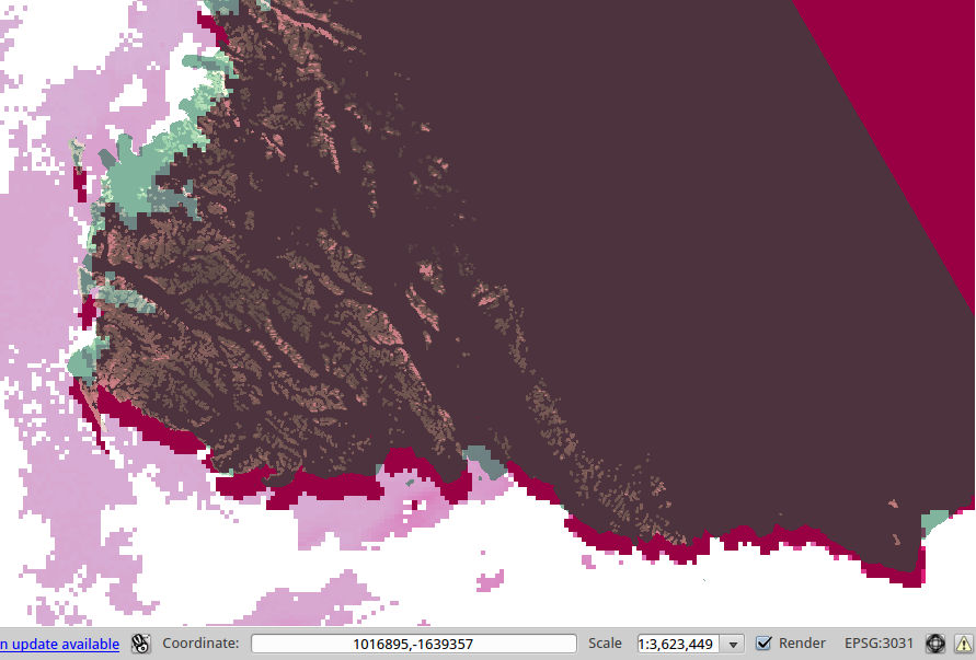
However, when compared with another dataset, the resulting layer presents a displacement. In the following image, the transparent, green layer is a reference layer in the Ross Sea region, while the dark purple is the land mask of the MODIS data:

I assume there is a problem in the definition of the projection, any pointer would be welcome.
EDIT
The configuration on my machine:
$ proj
Rel. 4.8.0, 6 March 2012
$ gdalinfo --version
GDAL 1.10.0, released 2013/04/24
EDIT2
Even more suprises: the exact same command is failing on one of our clusters:
$ gdalwarp  -s_srs '+proj=laea +lat_0=-5156620156.177409 +lon_0=0 +x_0=0 +y_0=0 +ellps=clrk66 +units=m +no_defs ' -t_srs EPSG:3031 'HDF4_EOS:EOS_GRID:"MOD29E1D.A2010357.005.2010358085416.hdf":MOD_Grid_Seaice_4km_South:Ice_Surface_Temperature_SP' foo.tif
ERROR 1: tolerance condition error
ERROR 1: tolerance condition error
ERROR 1: tolerance condition error
ERROR 1: tolerance condition error
ERROR 1: tolerance condition error
ERROR 1: tolerance condition error
ERROR 1: tolerance condition error
ERROR 1: tolerance condition error
ERROR 1: tolerance condition error
ERROR 1: tolerance condition error
ERROR 1: tolerance condition error
ERROR 1: tolerance condition error
ERROR 1: tolerance condition error
ERROR 1: tolerance condition error
ERROR 1: tolerance condition error
ERROR 1: tolerance condition error
ERROR 1: tolerance condition error
ERROR 1: tolerance condition error
ERROR 1: tolerance condition error
ERROR 1: Reprojection failed, err = -20, further errors will be supressed on the transform object.
Creating output file that is -2147483648P x -2147483648L.
ERROR 1: Attempt to create -2147483648x-2147483648 dataset is illegal,sizes must be larger than zero.
The configuration on this machine is:
$ proj
Rel. 4.9.0, 22 June 2013
$ gdalinfo --version
GDAL 1.11.0, released 2014/04/16

