3

I am new to ArcGIS. I have the EDN license (Desktop and Server); have setup ArcGIS for Server in our offline environment; have published several base maps (with caches that ESRI provided me on a DVD) as services; and can use those services with an ArcGisTiledMapServiceLayer from a Silverlight client we are building.

The map displays, I can add our graphics layers to it, and everything works great. But, I do not want to use the default projection that these base map caches have (the 102100 WKID as seen in this arcgisonline service http://services.arcgisonline.com/arcgis/rest/services/World_Street_Map/MapServer). I'd like to use the projection from here: http://services.arcgisonline.com/arcgis/rest/services/ESRI_StreetMap_World_2D/MapServer which is the WKID 4326.

Given just the base map caches that I have, is there any way for me to reproject the map? Can the client do it on-the-fly? Or can I configure ArcGis for Server to do that reprojection dynamically? Do I need to rebuild the whole cache some how to the new projection? Or find a new cache entirely?

2 Answers 2

2

Is there any particular reason not to serve the basemap with 3857 projection, such as your area of interest is at a high latitude? Almost all basemaps you can access freely on the internet is in this projection.

If you have all the original data, you can publish your own image service in perhaps any projection you want.

But for cached image service, it's not likely to change the projection, according to this article. Cached images are supposed to be used in the same projection as the one specified at their creation.

1
  • exactly, cache images are there to enhance the performances. If you reproject them you lose some performance.
    – radouxju
    Commented Oct 28, 2014 at 20:23
1

The questions you raise are some of the fundamental trade-offs between performance and flexibility of tiled services.

The short answer is: No, you can't reproject it 'on-the-fly' either at the server or client.

In my opinion, your best choice is to adopt the web-mercator alternate sphere projection. The next-best solution is to recreate the cache in the unprojected geographic coordinate system of your preference. (Notice I didn't say 'projection.')

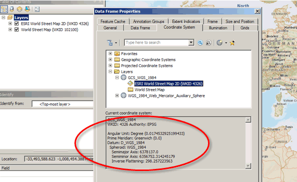
Let me unpack my answer a bit: First you explain that you are new to ArcGIS, but I am going to assume you are NOT new to GIS. I added your two example services to ArcGIS for Desktop so I could reveal the differences between the two WKIDs of interest. WKID 102100 is a Mercator 'projection' defined simply/efficiently on top of the WGS coordinate spheroid (see screenshot 1.) The WKID 4326 is NOT a projection, it is the spherical (geographic) coordinate system (see screenshot 2.) Screenshot 1: Definition of Web-mercator Projection
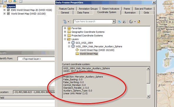
Screenshot 2: definition of geographic coordinate system

This difference is why I encourage you to adopt the web-mercator 'projection' -- managing geographic data has complexities and managing a tiled image service adds even more complexity once you attempt to build tiles above/below 70degrees latitude. Recall that these tiles are supposed to be rectangular, but the lines of longitude converge at the poles, so a spherical coordinate system like WKID 4326 doesn't break up into rectanglular tiles nicely. In contrast, the web-mercator projected data has already been 'flattened' to a rectangular grid. Obviously, this grid is well-suited for cache tiling.

This link explains why the WKID in screenshot 1 reads 3857 instead of 102100.

Because of how the web-mercator projection is defined, the tile images from the two services overlay each other in central latitudes...but the differences get large when we move away from the equator. If you were able to re-project the mercator tiles onto the geographic basis, annotation and linear features appear fuzzy and squashed top-to-bottom as in the screenshot below. <-- Remember that Desktop ArcGIS can do this re-projection on-the-fly, just not web.

Comparison of Re-projection Artifacts (left image:mercator; right image:spherical)

Hopefully, all of this discussion has swayed you toward adopting the web-mercator projection as the tiling scheme for your cache. There are lots of support materials for creating your cache if you choose that alternate solution.

Good luck either way.

3
  • I appreciate your thorough answer. I'm not quite sold on Web Mercator yet and I'd like to explore other options. Can you elaborate on you final sentence about support materials for creating my own cache?
    – koopaking3
    Commented Oct 29, 2014 at 1:01
  • Sure thing. This ESRI webhelp page (help.arcgis.com/en/arcgisserver/10.0/help/…) discusses the details of planning a map cache, including the not-so-informative sectyion on coordinate systems. That page is within the section of the Deploying Map Caches. I recommend reviewing the entire chapter entitled 'How to Publish Services' (but I can't link to chapters in webhelp.) Commented Oct 29, 2014 at 18:16
  • Furthermore, this GeoNet forum post (geonet.esri.com/message/…) is precisely in the vein of your question as it deals with cache services in geographic coordinates. Commented Oct 29, 2014 at 18:45

Your Answer

By clicking “Post Your Answer”, you agree to our terms of service and acknowledge you have read our privacy policy.

Not the answer you're looking for? Browse other questions tagged or ask your own question.