5

I am new to using QGIS and I am currently trying to put roads onto my canvas.

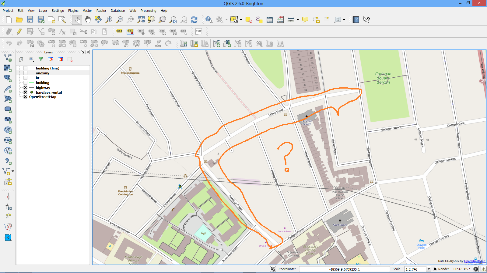
I have tried adding only 'highway' and 'oneway' polyline tags from the OSM database, but there is still a few roads missing (see picture, circled in orange)

I kind of assumed high way will cover all the roads (apparently not!)

Is there an efficient way to find out which tag I have missed? (instead of trial and error with all the polyline tags)

enter image description here

4
  • How did you get the data from the OSM database?
    – AndreJ
    Commented Nov 6, 2014 at 17:45
  • @AndreJ: I downloaded osm file from clicking export from Open Street Map website Commented Nov 6, 2014 at 17:50
  • I just did the same and the ways are included. How did you import them? You can use either "Add vector layer" or "Vector -> Openstreetmap".
    – AndreJ
    Commented Nov 6, 2014 at 17:55
  • @AndreJ I just tried exporting again and somehow it worked... Anyway thanks for the help! Do you know if there is a difference between downloading osm file from "Vector > openstreetmap > download data" and downloading from website? (sorry if this sounds stupid) Commented Nov 6, 2014 at 18:06

2 Answers 2

2

You have several opportunities to load OSM data into QGIS:

  1. export the current view from the website
  2. In QGIS, use Vector -> Openstreetmap to download the current map canvas or a layer extent
  3. Use Overpass API
  4. In QGIS, use QuickOSM plugin (with Overpass API in the background)
  5. In QGIS, use Add vector layer to load osm files gathered from step 1 to 4
  6. Use GDAL to load osm files from step 1 to 4 into a spatialite database
  7. Download extracts from Geofabrik, filter them if you want and import them into a Postgis database with osm2pgsql

All methods have their pros and cons, but only the last one will get you all elements in the way you see them on the map. Simply because this is the way the map tiles are created.

There are no fixed rules on how things have to be tagged in QGIS, and so every import method uses some most popular tagging rules. No reason to complain about it, you get what you paid for...


EDIT

One pitfall we encountered sometimes is that points and ways get lost if the nodes and ways are not delivered sorted by ID. The OSM API does not guarantee that. I'm not sure which import method takes care of that, but Geofabrik extracts are safe on that.

The only pitfall for the Postgis method is an osm2pgsql version prior to 2012, since OSM node IDs have hit the 32-bit limit. Since then, especially Windows users are lacking a stable version. The latest development on that can be followed here.
1

You can look up the tags of the missing roads by opening the data layer. The roads highlighted by you are way 10788396 and way 8399181. As you can see both ways have the highway tag. Hence there has been either a problem while exporting the data from OSM or while importing it into QGIS.

Your Answer

By clicking “Post Your Answer”, you agree to our terms of service and acknowledge you have read our privacy policy.

Not the answer you're looking for? Browse other questions tagged or ask your own question.