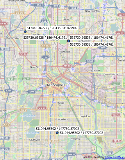
I'm using QGIS to do some data analysis and visualization for my newspaper and I'm a basic/novice user at all this.
I received some x,y coordinates from the City of Minneapolis that I can use to build some static graphical maps shaped like Minneapolis, because QGIS nicely plops the markers on my Minneapolis street centerline shapefile. They're using a county-level coordinate reference system that's not in the EPSG dataset.
But where it gets tricky is attempting to stick those coordinates on a basemap using Leaflet or similar solutions. Those interactive mapping tools seem to need latitude/longitude coordinates and choke on the projected coordinates.
So I've attempted to convert the coordinates to lat/longs. Here's a sample of what Minneapolis sent me in CSV format:
itm,utm
531044.956020000000000,147730.870020000000000 531044.956020000000000,147730.870020000000000 535730.695380000000000,186474.417610000000000 535730.695380000000000,186474.417610000000000 535730.695380000000000,186474.417610000000000 517443.467270000000000,190435.841829999000000
Pretty much every converter I've used -- including QSIG tools like the field calculator, export/add geometry columns, mmqgis, etc -- converts them and sticks the markers in a Minneapolis-shape in the Pacific Ocean off South America and spits this out in the attribute table:
itm,utm,XCOORD,YCOORD
531044.956020000000000,147730.870020000000000,-92.720933,1.336549 531044.956020000000000,147730.870020000000000,-92.720933,1.336549 535730.695380000000000,186474.417610000000000,-92.678761,1.687061 535730.695380000000000,186474.417610000000000,-92.678761,1.687061 535730.695380000000000,186474.417610000000000,-92.678761,1.687061 517443.467270000000000,190435.841829999000000,-92.843170,1.722921
Here are the details Minneapolis sent me about their Coordinate System (they don't have a converter either, I'm told):
The Spatial Reference ID # is Esri::103734.

Projection: Lambert_Conformal_Conic

False_Easting: 500000.000000
False_Northing: 100000.000000
Central_Meridian: -93.383333
Standard_Parallel_1: 44.883333
Standard_Parallel_2: 45.133333
Latitude_Of_Origin: 44.791111

Linear Unit: Foot_US (0.304801)

Geographic Coordinate System:
GCS_NAD_1983_HARN_Adj_MN_Hennepin
Angular Unit: Degree (0.017453292519943299)
Prime Meridian: Greenwich (0.0)
Datum: D_NAD_1983_HARN_Adj_MN_Hennepin
Spheroid: S_GRS_1980_Adj_MN_Hennepin
Semimajor Axis: 6378418.9409999996
Semiminor Axis: 6357033.3098455509
Inverse Flattening: 298.2572221008827
The equivalent ProjCRS well-known text is:
PROJCS["NAD_1983_HARN_Adj_MN_Hennepin_Feet",GEOGCS["GCS_NAD_1983_HARN_Adj_MN_Hennepin",DATUM["D_NAD_1983_HARN_Adj_MN_Hennepin",SPHEROID["S_GRS_1980_Adj_MN_Hennepin",6378418.941,298.2572221008827]],PRIMEM["Greenwich",0.0],UNIT["Degree",0.0174532925199433]],PROJECTION["Lambert_Conformal_Conic"],PARAMETER["False_Easting",500000.0],PARAMETER["False_Northing",100000.0],PARAMETER["Central_Meridian",-93.38333333333334],PARAMETER["Standard_Parallel_1",44.88333333333333],PARAMETER["Standard_Parallel_2",45.13333333333333],PARAMETER["Latitude_Of_Origin",44.79111111111111],UNIT["Foot_US",0.3048006096012192],AUTHORITY["Esri",103734]]
and the GeoCRS WKT is:
GEOGCS["GCS_NAD_1983_HARN_Adj_MN_Hennepin",DATUM["D_NAD_1983_HARN_Adj_MN_Hennepin",SPHEROID["S_GRS_1980_Adj_MN_Hennepin",6378418.941,298.2572221008827]],PRIMEM["Greenwich",0.0],UNIT["Degree",0.0174532925199433]]
QGIS reads the coordinates using NAD83(CSRS) / UTM zone 15N (though whenever I look at a UTM grid, it seems to place Minnesota in 15T)?
I'm looking for a long term solution to work with the coordinate system, since we're likely to receive more data like this from the city and Hennepin County.

