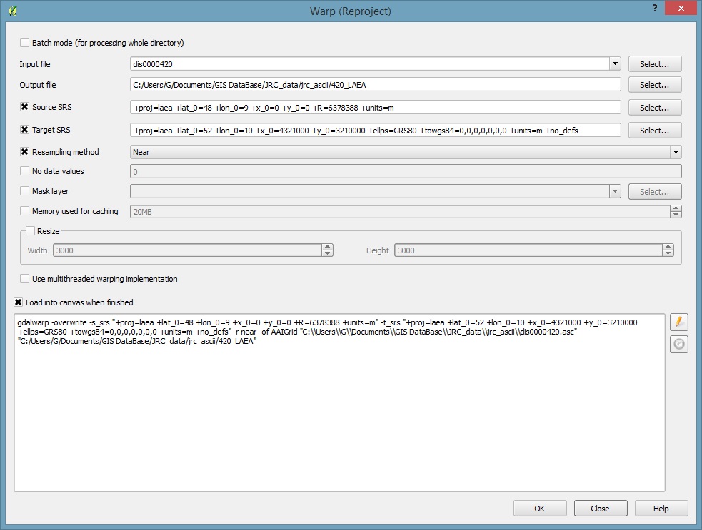
I'm currently struggling to convert a small .asc dataset with no defined projection. The projection that has to be first applied is Lambert Azimuthal "old" projection:
In PROJ.4
+proj=laea +lat_0=48 +lon_0=9 +x_0=0 +y_0=0 +R=6378388 +units=m
or In ArcGIS
Radius of sphere of reference  6378388m
Longitude of center of projection 9 0 0 (Degrees Minutes Seconds)
Latitude of center of projection 48 0 0 (Degrees Minutes Seconds)
False Easting 0 m
False Northing 0 m

projection lambert_azimuthal
units meters
spheroid sphere
The target projection is EPSG:3035 with
PROJ.4
+proj=laea +lat_0=52 +lon_0=10 +x_0=4321000 +y_0=3210000 +ellps=GRS80 +towgs84=0,0,0,0,0,0,0 +units=m +no_defs.
or in ArcGIS
Projected Coordinate System:    ETRS_1989_LAEA
Projection: Lambert_Azimuthal_Equal_Area
False_Easting:  4321000.00000000
False_Northing: 3210000.00000000
Central_Meridian:   10.00000000
Latitude_Of_Origin: 52.00000000
Linear Unit:    Meter

Geographic Coordinate System:   GCS_ETRS_1989
Datum:  D_ETRS_1989
Prime Meridian:     Greenwich
Angular Unit:   Degree
I'm using the Warp (QGis tool), and this is what I got.

Output driver **`AAIGrid' not recognised or does not support
direct output file creation. The following format drivers are configured
and support direct output**:
GeoRaster: Oracle Spatial GeoRaster
VRT: Virtual Raster
GTiff: GeoTIFF
NITF: National Imagery Transmission Format
HFA: Erdas Imagine Images (.img)
ELAS: ELAS
MEM: In Memory Raster
BMP: MS Windows Device Independent Bitmap
PCIDSK: PCIDSK Database File
ILWIS: ILWIS Raster Map
SGI: SGI Image File Format 1.0
Leveller: Leveller heightfield
Terragen: Terragen heightfield
netCDF: Network Common Data Format
HDF4Image: HDF4 Dataset
ISIS2: USGS Astrogeology ISIS cube (Version 2)
ERS: ERMapper .ers Labelled
RMF: Raster Matrix Format
RST: Idrisi Raster A.1
INGR: Intergraph Raster
GSBG: Golden Software Binary Grid (.grd)
GS7BG: Golden Software 7 Binary Grid (.grd)
PNM: Portable Pixmap Format (netpbm)
ENVI: ENVI .hdr Labelled
EHdr: ESRI .hdr Labelled
PAux: PCI .aux Labelled
MFF: Vexcel MFF Raster
MFF2: Vexcel MFF2 (HKV) Raster
BT: VTP .bt (Binary Terrain) 1.3 Format
LAN: Erdas .LAN/.GIS
IDA: Image Data and Analysis
GTX: NOAA Vertical Datum .GTX
NTv2: NTv2 Datum Grid Shift
CTable2: CTable2 Datum Grid Shift
KRO: KOLOR Raw
ADRG: ARC Digitized Raster Graphics
SAGA: SAGA GIS Binary Grid (.sdat)
What I really don't know is why I cannot find or define a new projection for the .asc files and then hopefully to transform them into the ETRS_1989_LAEA. So these probably has to be done like this (?)
Define the default projection for the dataset
Transform the projection to the ETRS_1989_LAEA
My question mainly focuses on (1).Any idea about how it can be done in ArcMap or even in QGIS?
