2

I am new in working with the Network Analyst tool in ArcGIS. I am trying to find the closest facility to some assigned incidents.

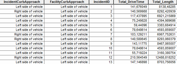
The result that I am taking after I solve the paths is in minutes. However, the minutes appear to be 'off', e.g an 8km drive - results in 141 minutes.

Please see the image below.

enter image description here

I have also added polygon barriers with Attr_DriveTime as Scaled Cost with the value of 3, assuming that this is a "slowing down" factor.

Are the results that I am talking walking time from the facilities to the incidents?

How can I add the real truck (car) driving time?

3
  • I've always had to add my own drive-time column to my road data and calculate them based on length of road and average speed (on that road). I've not had network analyst create this data for me (I don't think it will), so you may need to re-calculate your drive time column to match your truck speeds.
    – Midavalo
    Commented Feb 23, 2016 at 17:26
  • for example a 1km road at 50km/h (or 14m/s) will take 71s not allowing for time taken to speed up or slow down at intersections etc., so we'd use a value of 71 in our drive-time column for that 1km road.
    – Midavalo
    Commented Feb 23, 2016 at 17:30
  • @Midavalo I think you have enough in your comments to write a brief answer.
    – PolyGeo
    Commented Oct 26, 2016 at 7:56

0

Your Answer

By clicking “Post Your Answer”, you agree to our terms of service and acknowledge you have read our privacy policy.