1

I used Atlas in QGIS 2.14 to generate an image (map) and an associate world file for each lakes (> 5000) in my database.

I want to be able to see all the data in MS Excel as following:

  • 1st column : Name of the lake (in my case, the file name)
  • 2nd column : 1st line in the world file
  • 3rd column : 2nd line in the world file
  • 4th column : 3rd line in the world file
  • 5th column : 4th line in the world file
  • 6th column : 5th line in the world file
  • 7th column : 6th line in the world file

With each line being one lake.

Is there a way in QGIS (or any other GIS) to get one "super" world file for all my lakes instead of one per lake?

If not, is there any other way to merge all the files to get the same result?

EDIT : In case I'm not asking the right question, what I ultimately want is an MS Excel file with the lakes' name in one column and the corner coordinates of the map (jpg image) in separate columns.

1

1 Answer 1

0

If I understood your problem, it'd be solved by merging all shapefiles into one. It's as simple as vector -> data management tools -> merge shapefiles and then select the directory your shapefiles are into and where do you want your merged shapefile saved to.

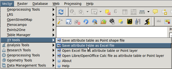
I see, you'd either select all in the attribute table and paste it in excel, or install the xytools plugin and save attribute table to excel enter image description here

2
  • All my lakes are already in a single Shapefile. I'm using Atlas to get a separate map (jpg image) for each lake. Atlas also generates a World file for each map. What I need is one MS Excel file with all the World files data inside.
    – Nahas
    Commented May 2, 2016 at 16:03
  • Ok, found my answer on stackoverflow.
    – Nahas
    Commented May 3, 2016 at 13:08

Your Answer

By clicking “Post Your Answer”, you agree to our terms of service and acknowledge you have read our privacy policy.

Not the answer you're looking for? Browse other questions tagged or ask your own question.