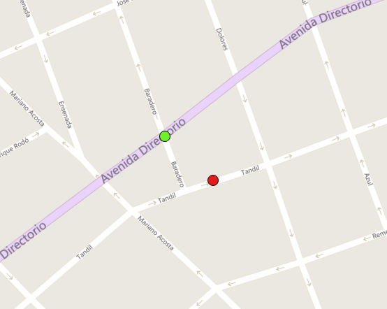
I'm trying to convert a local PCS (city of Buenos Aires) to wgs1984. Since the PCS is not included in Postgis, I added it to spatial_ref_sys using spatialreference.org (I compared the arguments with a .prj I know is right and they match). My coordinates for the PCS are in WKT, so to make my geometry column in wgs I used:
update <my_table>
set geom = ST_Transform(ST_SetSRID(ST_GeomFromText(<wkt_column>), <PCS_number>), 4326);
Which works at first glance, but the points are off by approx. 50 meters in relation with my other wgs tables.
When I make the transformation using the Project tool on Arcgis, it works perfect. The difference I see is that Arcgis offers me to use different 'Geographic transformation methods' to make the transformation. The one I choose, and it works fine, is 'Campo_Inchauspe_To_Posgar_2007_1 + Posgar_2007_To_Wgs_1984_1'. I suspect that this method is the key to solve this, but in that case I don't have a clue on how to include that method in the Postgis transformation.
My .prj is this:
PROJCS["Argentina_GKBsAs",
GEOGCS["GCS_Campo_Inchauspe",
DATUM["D_Campo_Inchauspe",
SPHEROID["International_1924",6378388.0,297.0]],
PRIMEM["Greenwich",0.0],UNIT["Degree",0.0174532925199433]],
PROJECTION["Transverse_Mercator"],
PARAMETER["False_Easting",100000.0],
PARAMETER["False_Northing",100000.0],
PARAMETER["Central_Meridian",-58.4627],
PARAMETER["Scale_Factor",0.999998],
PARAMETER["Latitude_Of_Origin",-34.6297166],
UNIT["Meter",1.0]]
The projection number in spatialreference.org is 8333, and here you can see it in wkt as html for comparison:
PROJCS["Gauss Krugger BA", GEOGCS["GCS_Campo_Inchauspe", DATUM["D_Campo_Inchauspe", SPHEROID["International_1924",6378388.0,297.0]], PRIMEM["Greenwich",0.0], UNIT["Degree",0.0174532925199433]], PROJECTION["Transverse_Mercator"], PARAMETER["False_Easting",100000.0], PARAMETER["False_Northing",100000.0], PARAMETER["Central_Meridian",-58.4627], PARAMETER["Scale_Factor",1.0], PARAMETER["Latitude_Of_Origin",-34.6297166], UNIT["Meter",1.0]]
Here is the Postgis insert statement:
INSERT into spatial_ref_sys (srid, auth_name, auth_srid, proj4text, srtext) values ( 98333, 'sr-org', 8333, '+proj=tmerc +lat_0=-34.6297166 +lon_0=-58.4627 +k=1 +x_0=100000 +y_0=100000 +ellps=intl +units=m +no_defs ', 'PROJCS["Gauss Krugger BA",GEOGCS["GCS_Campo_Inchauspe",DATUM["D_Campo_Inchauspe",SPHEROID["International_1924",6378388.0,297.0]],PRIMEM["Greenwich",0.0],UNIT["Degree",0.0174532925199433]],PROJECTION["Transverse_Mercator"],PARAMETER["False_Easting",100000.0],PARAMETER["False_Northing",100000.0],PARAMETER["Central_Meridian",-58.4627],PARAMETER["Scale_Factor",1.0],PARAMETER["Latitude_Of_Origin",-34.6297166],UNIT["Meter",1.0]]');
So, I have one point in wgs:
-58.47532313, -34.63847446
And I make the geometry (Point, 4326) in one table
Then I take the same point in the PCS (8333):
POINT(98897.6171875 98978.84375)
And I make the geometry (Point, 4326) out of the following transformation:
update test_t
set geom = ST_Transform(ST_SetSRID(ST_GeomFromText(coord), 98333), 4326);
I get this when I pick the point in Qgis:
Being the green point the correct one (the one originally in wgs), and the red the misplaced one (the transformed).


spatial_ref_sys. Provide a point in the PCS, the incorrect WGS84 value you get, and the known correct transformed point location in WGS84. Then folks can do a bit of research and confirm if they have a solution without a lot of back and forth.