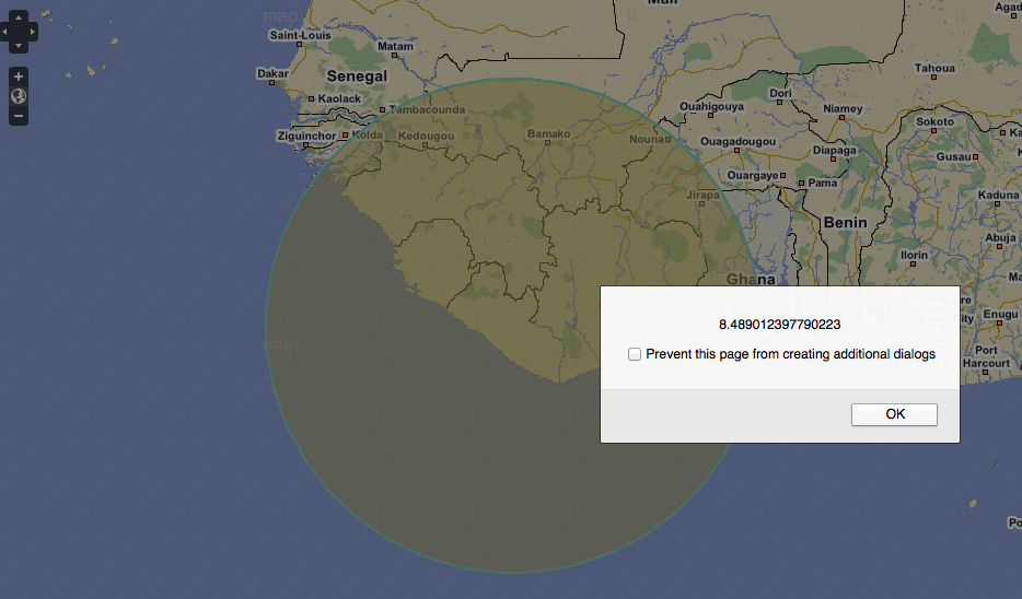
I have made a Openlayers integrated map that lets you draw a circle, On completion of the circle I have told the map to give me , Bounds, Center Long and Lats, and lastly the radius. My problem is that I can't understand in what decimal it gives the radius to me in. Below is a image that shows you I have drawn a very large circle and the alert for the radius. How many kilometers is this? (I made a google map with the same functionality and the radius works in meters with EPSG Projection.

Below is my code. I am using CRS:84 for my map projection.
Here is the initial bit of code I want working in Meters rather than the decimal structure of the above picture.
            vectors.events.on({
          featuremodified: onFeatureModified
       });

          function onFeatureModified(event) {
           var bounds = event.feature.geometry.getBounds();
           var answer = "bottom: " + bounds.bottom + "\n";
           answer += "left: " + bounds.left + "\n";
           answer += "right: " + bounds.right + "\n";
           answer += "top: " + bounds.top + "\n";
           alert(answer);
           var area = event.feature.geometry.getArea();
           var radius = 0.565352 * Math.sqrt(area);
           alert(radius);
           var lonlat = event.feature.geometry.getBounds().getCenterLonLat()
           alert(lonlat);
Below this is my complete html document:
    <html xmlns="http://www.w3.org/1999/xhtml">
    <head>
    <!--CSS for Map -->
    <style type="text/css">
    html, body, #map {
    margin: 0;
    width: 100%;
    height: 100%;
    }
    </style>
    <!-- END of CSS for Map -->

    <!--CSS for Controls to draw circle and navigate -->
    <style type="text/css">
    #controls {
    position: absolute;
    bottom: 1em;
    left: 100px;
    width: 400px;
    z-index: 20000;
    padding: 0 0.5em 0.5em 0.5em;
    }

    #controlToggle {
    padding-left: 1em;
    }

    #controlToggle li {
    list-style: none;
    }

    #form {
    position: absolute;
    bottom: 1em;
    left: 400px;
    width: 200px;
    z-index: 20000;
    padding: 0 0.5em 0.5em 0.5em;
    }
   </style>
   <!-- END CSS for Controls to draw circle -->

  <link href="css/style.css" rel="stylesheet" type="text/css" />
  <script src="js/firebug.js"></script>
  <script src="js/OpenLayers.js"></script>

  <script type="text/javascript">
   var lon = 24.0000000000;
   var lat = -29.000000000000;

   var zoom = 4;
   var map, layer, vectors, controls;

   function init() {

       // Because the Streetmaps system uses 300x300 tiles, we need to set up the scaling variables to work with these
       var aRes = [90, 45, 22.500000, 11.250000, 5.625000, 2.812500, 1.406250, 0.703125, 0.351563, 0.175781, 0.087891, 0.043945, 0.021973, 0.010986, 0.005493, 0.002747, 0.001373, 0.000687, 0.000343];
       for (var l = 0; l < aRes.length; l++) { aRes[l] = aRes[l] / 300; }

       // Normal init, but we pass through the info about the zoom/scaling as options
       map = new OpenLayers.Map('map', { tileSize: new OpenLayers.Size(300, 300), projection: 'CRS:84',units: "m", numZoomLevels: aRes.length, resolutions: aRes, maxResolution: 360 / 300 });

       // At this point the control is used as per normal
       layer1 = new OpenLayers.Layer.WMS(
              'Streetmaps Streets',
              'http://www.streetmaps.co.za/WMS/?',
              {
                  key: 'HZPGNWPNDYPREPTIKSIHWKYKQYYOQVYX',
                  service: 'WMS',
                  request: 'GetMap',
                  version: '1.3.0',
                  layers: 'sm.maps.tiled',
                  format: 'image/png'
              }
    );

       layer2 = new OpenLayers.Layer.WMS(
              'Streetmaps Imagery',
              'http://www.streetmaps.co.za/WMS/?',
              {
                  key: 'HZPGNWPNDYPREPTIKSIHWKYKQYYOQVYX',
                  service: 'WMS',
                  request: 'GetMap',
                  version: '1.3.0',
                  layers: 'sm.imagery',
                  format: 'image/png'
              }
    );

       // This loads the map
       map.addLayer(layer1);
       map.addLayer(layer2);

       map.setCenter(new OpenLayers.LonLat(lon, lat), zoom);
       map.addControl(new OpenLayers.Control.LayerSwitcher());
       var vectors = new OpenLayers.Layer.Vector("vector", { isBaseLayer: true });
       map.addLayers([vectors]);

       // This loads the overlays
       var wms = new OpenLayers.Layer.WMS("OpenLayers WMS",
"http://vmap0.tiles.osgeo.org/wms/vmap0?", { layers: 'basic' });
       OpenLayers.Feature.Vector.style['default']['strokeWidth'] = '2';

       // allow testing of specific renderers via "?renderer=Canvas", etc
       var renderer = OpenLayers.Util.getParameters(window.location.href).renderer;
       renderer = (renderer) ? [renderer] : OpenLayers.Layer.Vector.prototype.renderers;

       vectors = new OpenLayers.Layer.Vector("Vector Layer", {
           renderers: renderer
       });

       map.addLayers([wms, vectors]);
       map.addControl(new OpenLayers.Control.LayerSwitcher());
       map.addControl(new OpenLayers.Control.MousePosition());
       map.setCenter(new OpenLayers.LonLat(lon, lat), zoom);

       // Now we call an alert to get the bounds or coordinates from a circle or vector we have drawn
       vectors.events.on({
           featuresadded: onFeaturesAdded
       });

       function onFeaturesAdded(event) {
           var bounds = event.features[0].geometry.getBounds();
           var answer = "bottom: " + bounds.bottom + "\n";
           answer += "left: " + bounds.left + "\n";
           answer += "right: " + bounds.right + "\n";
           answer += "top: " + bounds.top + "\n";
           alert(answer);
           var area = event.features[0].geometry.getArea();
           var radius = 0.565352 * Math.sqrt(area);
           alert(radius);
           var lonlat = event.features[0].geometry.getBounds().getCenterLonLat()
           alert(lonlat);

           // GET CENTER LAT + LON
           // AUTOMATICALLY INITIATE: onFeatureModified (Incl. Click)
           // DISABLE DRAW FEATURE

           // ASSIGN VALUES TO HIDDEN FIELDS IN FORM:
           //document.forms.item('hiddenfield').value = answer;
       }

       vectors.events.on({
          featuremodified: onFeatureModified
       });

          function onFeatureModified(event) {
           var bounds = event.feature.geometry.getBounds();
           var answer = "bottom: " + bounds.bottom + "\n";
           answer += "left: " + bounds.left + "\n";
           answer += "right: " + bounds.right + "\n";
           answer += "top: " + bounds.top + "\n";
           alert(answer);
           var area = event.feature.geometry.getArea();
           var radius = 0.565352 * Math.sqrt(area);
           alert(radius);
           var lonlat = event.feature.geometry.getBounds().getCenterLonLat()
           alert(lonlat);

           // DISABLE DRAW FEATURE

           // ASSIGN VALUES TO HIDDEN FIELDS IN FORM:
           //document.forms.item('hiddenfield').value = answer;y
       }

       controls = {
           regular: new OpenLayers.Control.DrawFeature(vectors,
            OpenLayers.Handler.RegularPolygon,
            { handlerOptions: { sides: 40} }),
           modify: new OpenLayers.Control.ModifyFeature(vectors)
       };

       for (var key in controls) {
           map.addControl(controls[key]);
       }

       map.setCenter(new OpenLayers.LonLat(0, 0), 3);
       document.getElementById('noneToggle').checked = true;
       }

       function update() {
       // reset modification mode
       //controls.modify.mode = OpenLayers.Control.ModifyFeature.RESHAPE;
       controls["modify"].activate();
       controls.modify.mode = OpenLayers.Control.ModifyFeature.ROTATE;

       var resize = document.getElementById("resize").checked;
       if (resize) {
           controls.modify.mode |= OpenLayers.Control.ModifyFeature.RESIZE;
           var keepAspectRatio = document.getElementById("keepAspectRatio").checked;
           if (keepAspectRatio) {
               controls.modify.mode &= ~OpenLayers.Control.ModifyFeature.RESHAPE;
           }
       }

       var drag = document.getElementById("drag").checked;
      if (drag) {
          controls.modify.mode |= OpenLayers.Control.ModifyFeature.DRAG;
      }

       //          if (rotate || drag) {
       //              controls.modify.mode &= ~OpenLayers.Control.ModifyFeature.RESHAPE;
       //          }
       //          var sides = parseInt(document.getElementById("sides").value);
       //          sides = Math.max(3, isNaN(sides) ? 0 : sides);
       //          controls.regular.handler.sides = sides;
       //          var irregular = document.getElementById("irregular").checked;
       //          controls.regular.handler.irregular = irregular;
   }


   function toggleControl(element) {
       for (key in controls) {
           var control = controls[key];
           if (element.value == key && element.checked) {
               control.activate();
           } else {
               control.deactivate();
           }
       }
   }
</script>
</head>
<body onLoad="init()">
<div id="map" class="smallmap"></div>
<div id="controls">
<ul id="controlToggle">
  <li>
<input type="radio" name="type" value="none" id="noneToggle"
       onclick="toggleControl(this);" checked="checked" />

  <label for="noneToggle">navigate</label>
  </li>
   <li>
  <input type="radio" name="type" value="regular" id="regularToggle" onClick="toggleControl(this);" />
<label for="regularToggle">draw regular polygon</label>
 </li>
 <li>
   <input type="radio" name="type" value="modify" id="modifyToggle"
       onclick="update();" />

      <label for="modifyToggle">modify feature</label>
  <ul>
    <li>
          <input id="rotate" type="hidden"
               name="rotate" onChange="update()"  checked="checked"/>
    </li>
    <li>
        <input id="resize" type="hidden"
               name="resize" onChange="update()"  checked="checked"/>
        <input id="keepAspectRatio" type="hidden"
               name="keepAspectRatio" onChange="update()" checked="checked" />
        <label for="keepAspectRatio"></label>
    </li>
    <li>
        <input id="drag" type="hidden"
               name="drag" onChange="update()"  checked="checked"/>
    </li>
  </ul>
  </li>
  </ul>
  </div>
  </body>
  </html>

