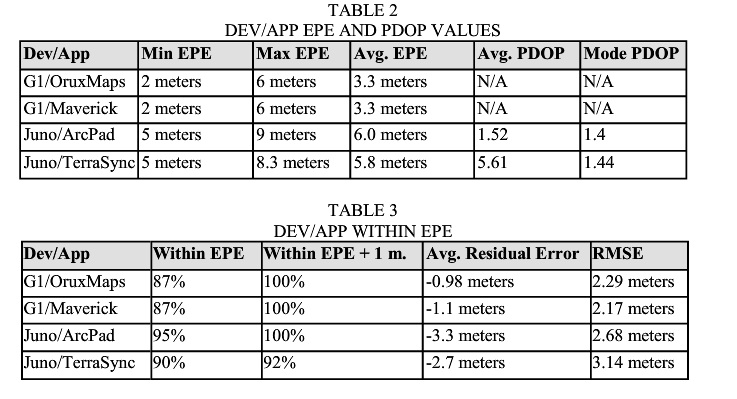
The best accuracy you are going to get with a phone or tablet device is 20-30 meters. So you have to ask yourself what is the purpose of your GPS? If you intend on navigating back to the asset in question, do you really want your users within 20-30 meters, is that accurate enough for what you are attempting to capture.
What the higher end GPS receivers give you like the Trimble GeoXH 6000 series, is 4 inch accuracy or better as they just released an add on for decimeter accuracy. In my case we are in the utility industry and we use a VRS(Virtual Referencing System) in Ohio which allows us to achieve 4 inch accuracy without any post-processing, it is real time in the field.
This means less overhead back in the office and we can store all GPS information in the attribute tables as data is being captured using the AddXYZ applet for ArcPad. Using the higher end equipment coupled with higher end software like ArcPad or TerraSync allows you to make checking data in and out and edit operations seamless.
So again, what is the end goal and does the money you spend up front give you a ROI in the long run. If automation, easy of use, and integration mean a lot to your company then I would suggest using Esri(ArcMap coupled with ArcPad), Trimble(GPS Correct, possibly GPS Analyst if you are going to post process), from here use a geodatabase(file or SDE). Now you can automate getting data in and out seamlessly using python or model builder. Then getting the data back in can be done using the same scripting methods as well.
Think of GPS units like cars
Phone/Tablets - Like a pinto
Trimble GPS units - The cadillac
If you are just going to use the phone/tablet setup for attribute collection you should be fine, they are perfect for that. But if you expect to navigate back to the asset good luck.

