2

I have parcels in one layer which are simple polygons. As one parcel is against it's neighbor the lines of that boundary are shared. This makes it very difficult to symbolize the parcels in different outline colors.

I found a way to deal with it here: Displaying adjacent polygon lines beside each other instead of overlapping

Unfortunately, this fix does not hold when I export into KMZ using the Map to KML tool.

Can someone help me figure out a solution for this that can give me a good solution in the end product of a Google Earth KMZ file?

enter image description here

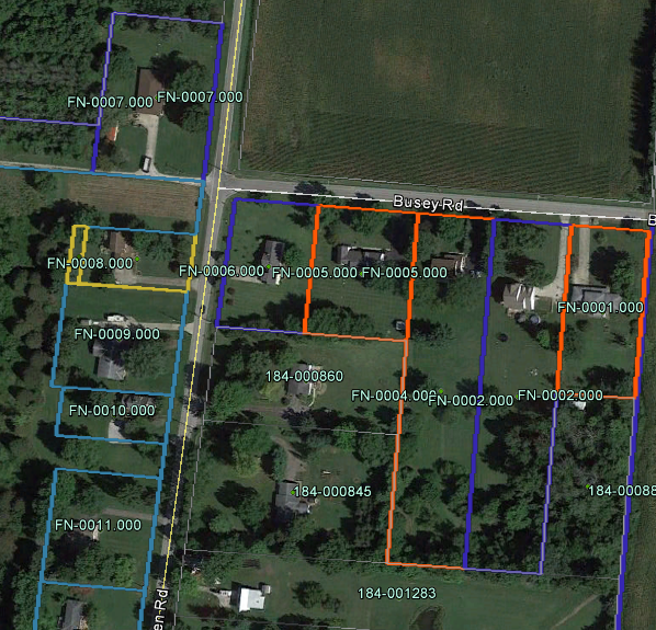
This is what I am actually dealing with in GE. enter image description here

12
  • What about the other solution doesn't work for you? What happens when you try this with KMZ that you don't like?
    – Midavalo
    Commented Feb 15, 2017 at 21:25
  • Convert to lines, show common line as blue/green line. Place transparent polygons underneath, so click inside will bring polygons info
    – FelixIP
    Commented Feb 16, 2017 at 3:33
  • @Midavalo The solution of changing the outline to a negative works GREAT inside of Arcmap, but the output to KML/KMZ Google Earth renders the polygon lines in the same position before the outline offset... basically, there is NO change.
    – Jim Garner
    Commented Feb 16, 2017 at 4:06
  • @JimGarner please edit your question to include all this information
    – Midavalo
    Commented Feb 16, 2017 at 4:07
  • Thank you @FelixIP but that will not work for my needs. I have colored symbology for each parcel based on WHO is working on it. So that in GE the users can see outlined colors far away or zoomed in. There are many so clicking to get the color is not going to help.
    – Jim Garner
    Commented Feb 16, 2017 at 4:09

1 Answer 1

2

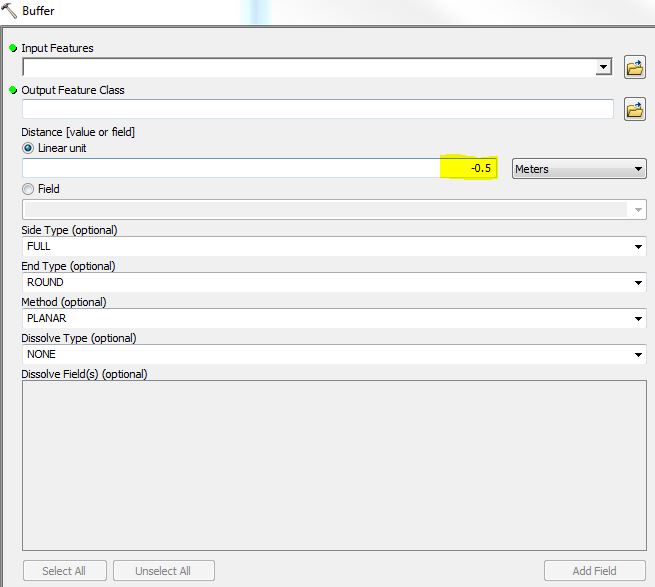
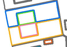
Use a negative buffer to offset the boundaries of the polygons. This will create a slight gap between each polygon allowing for the outline boundary not to overlap. Experiment with the negative number until you are satisfied. Set the Input, Output and (minus) Linear Unit, the rest of the fields can be left as default.The attribute values will remain in-tact for the output.

enter image description here

enter image description here

4
  • I think this is going to work! Thank you. I have to take it over to Google Earth to be sure, but I will mark it as answer as soon as I do. Be back soon!
    – Jim Garner
    Commented Feb 21, 2017 at 23:30
  • How do I mark this as an ANSWER? I clicked the button [POST YOUR ANSWER] but it appears to want ME to provide the answer. Um.... Found it!
    – Jim Garner
    Commented Feb 25, 2017 at 16:55
  • Although this is an answer for me to use, as the poster realizes this solution is dependent upon the zoom level of Google Earth. If anyone knows how to do this function EXCEPT with a setting to ALWAYS TOUCH, that would solve the issue. In essence, property parcels should have an option of each one having their own boundary sides, regardless of zoom.
    – Jim Garner
    Commented Feb 25, 2017 at 17:09
  • CAUTION: After trying to use this solution, it just does not work. Much thanx to the contributor @Clubdebambos. I believe we need an option to make non-coincidental lines, but lines that always appear to be touching, nonetheless. If Google Earth would allow the negative outline option this WOULD BE the solution, but I cannot see any option to do this. Perhaps there is a way in the Keyhole Markup Language that is allowed. Any thoughts?
    – Jim Garner
    Commented Mar 6, 2017 at 15:02

Your Answer

By clicking “Post Your Answer”, you agree to our terms of service and acknowledge you have read our privacy policy.

Not the answer you're looking for? Browse other questions tagged or ask your own question.