6

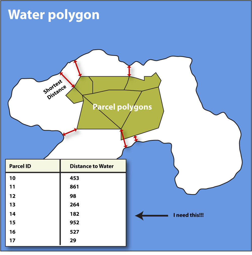
I have 2 sets of Polygons and I need to calculate the shortest distance between the polygons on one layer to the single polygon (one feature) on the other layer! How can I do that? Any help on how to accomplish this in QGIS?

The real world case is to calculate the shortest distance from the edge of a land parcel to the water/ocean. I will need to do this once or twice, but the multiple polygon layer has 10k's of features).

Being not of many words I have included an image of what I need to do!

Example on what I need to do!

6
  • Do you need to perform this task only a few times or in a programmatically way?
    – mgri
    Commented Sep 30, 2017 at 14:43
  • I just need to do it once or twice! The multiple polygon layer has some 25k poligons. But i would think that this must be a fairly common problem in GIS!?!
    – Mats Wedin
    Commented Sep 30, 2017 at 14:59
  • I have a very simple idea for general purposes, but please confirm me that the water polygon (colored with blue) is composed of only one feature.
    – mgri
    Commented Sep 30, 2017 at 15:04
  • Please Edit the question in response to requests for clarification. It is unfair to those who would help you to need to mine comments for critical information.
    – Vince
    Commented Sep 30, 2017 at 15:07
  • Yes the Water polygon is only one feature
    – Mats Wedin
    Commented Sep 30, 2017 at 15:17

2 Answers 2

6

Since you don't need to perform this task in a programmatically way, you may follow these simple steps:

  1. Select the water polygon layer from the Layers Panel;
  2. Open the Python Console:

enter image description here

  1. Open the editor and run the following code (see the image below):
layer=iface.activeLayer()
for feat in layer.getFeatures():
    print feat.geometry().exportToWkt()

enter image description here

  1. Copy the result (just double click on the line which starts with Polygon ((...)) and then ctrl+c);

  2. Select the land parcel layer from the Layers Panel and then open the Field Calculator. Create a new field with the following expression (see the image below):

    distance($geometry,geom_from_wkt( 'Polygon ((-1.06346153846153846 -0.68461538461538463, 1.27115384615384608 -0.68461538461538463, 1.27115384615384608 0.80000000000000004, -1.06346153846153846 0.80000000000000004, -1.06346153846153846 -0.68461538461538463),(-0.92959048475307471 0.66890818799452745, -0.94814336044880765 0.27311350648555988, -0.89248473336160905 0.08758474952823136, -0.92340619285449721 -0.07939113173336443, -0.86774756576729861 -0.27110418058927044, -0.80590464678152229 -0.40715860235797807, -0.6884031007085476 -0.53702873222810821, -0.55234867893983997 -0.54321302412668571, -0.42866284096828777 -0.54321302412668571, -0.31734558679389036 -0.54321302412668571, -0.23076550021380404 -0.57413448361957387, -0.10707966224225141 -0.57413448361957387, 0.07226480281649961 -0.53084444032953049, 0.20831922458520724 -0.49373868893806483, 0.36911081394822531 -0.51229156463379755, 0.65358824128279558 -0.56176589982241865, 0.97517142000883172 -0.48755439703948711, 1.00609287950171966 -0.38860572666224535, 1.04938292279176304 -0.21544555350207206, 1.07412009038607348 0.01337324674529994, 1.04319863089318554 0.09376904142680897, 1.0246457551974526 0.24219204699267183, 1.0308300470960301 0.39061505255853457, 1.07412009038607348 0.48337943103719894, 1.10504154987896186 0.61324956090732896, 0.93806566861736584 0.63180243660306168, 0.7216154521671494 0.62561814470448418, 0.59174532229701926 0.58851239331301841, 0.45569090052831163 0.61324956090732896, 0.38766368964395781 0.67509247989310506, 0.17121347319374136 0.67509247989310506, 0.02897475952645623 0.63180243660306168, -0.10089537034367391 0.60088097711017363, -0.45340000856259821 0.67509247989310506, -0.55234867893983997 0.693645355588838, -0.70077168450570282 0.70601393938599322, -0.92959048475307471 0.66890818799452745))' ))
    

enter image description here

Obviously, you need to replace the above WKT Polygon with your case. Furthermore, I assumed you wanted a field with decimals, so adapt it to your case.

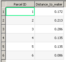
  1. This will create a new field storing a value which is the minimum distance from that feature to the water polygon:

enter image description here

3
  • I sort of get an error on the first part! indentationError!
    – Mats Wedin
    Commented Sep 30, 2017 at 15:59
  • @MatsWedin try to copy each single row manually (no problem for the first two rows, while add 4 blank spaces before pasting the third row). For copy, I mean copying the row by selecting it starting from the beginning of the first word in the line.
    – mgri
    Commented Sep 30, 2017 at 16:03
  • 1
    I got it to work i just ignored the error and followed your instructions! Awesome!
    – Mats Wedin
    Commented Sep 30, 2017 at 16:17
2

An update on mgri's answer, for anyone who's trying to solve this using QGIS 3.x.

.exportToWkt() has been deprecated, so use .asWkt() instead.

Your Answer

By clicking “Post Your Answer”, you agree to our terms of service and acknowledge you have read our privacy policy.

Not the answer you're looking for? Browse other questions tagged or ask your own question.