1

I have a shape file with nature preservation areas (Biosphärenreservate) in Germany. I think the projection must be something like gauss-krüger zone 4 Pulkovo or something like that. When I reproject it to UTM-33N WGS84 it reprojects but is not exactly accurate. The borders don't quite match my other shape (the other file)

http://www.projektidee.org/images/extern/biosph-res-2010.prj.zip http://www.projektidee.org/images/extern/gebiet_UTM33.dbf.zip

Could anyone here help me with that problem. That would be nice!

best regards desputin

5
  • Are you sure the projection of the other file is ok?
    – johanvdw
    Commented May 18, 2012 at 8:56
  • 3
    You may want to mark some of the answers to questions you've asked as "accepted", otherwise you might find you get fewer answers in the future. Commented May 18, 2012 at 8:57
  • Thanks for the advice. I don't see a "accept" button anywhere. (who created this stackexchange anyway? Half the time here has to be spent with burocracy!)
    – desputin
    Commented May 18, 2012 at 9:07
  • No I'm not 100% sure the biosphärenreservate are projected correctly.
    – desputin
    Commented May 18, 2012 at 9:15
  • Just a small wish: please less generic question titles...
    – markusN
    Commented May 18, 2012 at 22:02

1 Answer 1

6

Opening up biosph-res-2010.prj in a text editor, I get:

PROJCS["DHDN_3_Degree_Gauss_Zone_3",
  GEOGCS["GCS_Deutsches_Hauptdreiecksnetz",
    DATUM["D_Deutsches_Hauptdreiecksnetz",
    SPHEROID["Bessel_1841",6377397.155,299.1528128]],
    PRIMEM["Greenwich",0.0],
    UNIT["Degree",0.0174532925199433]],
  PROJECTION["Gauss_Kruger"],
  PARAMETER["False_Easting",3500000.0],
  PARAMETER["False_Northing",0.0],
  PARAMETER["Central_Meridian",9.0],
  PARAMETER["Scale_Factor",1.0],
  PARAMETER["Latitude_Of_Origin",0.0],
  UNIT["Meter",1.0]]

So you were almost right - I get the (apparently deprecated) DHDN / 3-degree Gauss zone 3 (EPSG:31463)

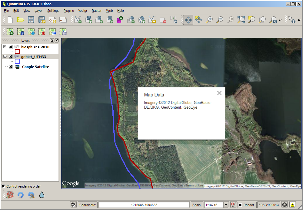
What I think your problem is, is not one of projection, but of digitization and simplification. Overlaying biosph-res-2010 (red) and gebiet_UTM33 (blue) on Google aerial imagery gives me this:

enter image description here

So your biosphärenreservate line matches the coast quite closely, but the blue line has far fewer points, and isn't shifted by a uniform amount. So the quality of your data is questionable rather than your projection.

0

Your Answer

By clicking “Post Your Answer”, you agree to our terms of service and acknowledge you have read our privacy policy.

Not the answer you're looking for? Browse other questions tagged or ask your own question.