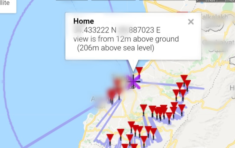
I wrote up some code that calculates the visible horizon as a polygon with 360 vertices
The output is a little rough but it works
from pathlib import Path

"""
##########################################################
User options
"""

#Variable assignment
inDEM        = 'C:/DEM.tif'
viewDist     = 3000
easting = '523926'
northing = '5258156'
crs = '[EPSG:28355]'

compressOptions         = 'COMPRESS=ZSTD|NUM_THREADS=ALL_CPUS|PREDICTOR=1|ZSTD_LEVEL=1|BIGTIFF=IF_SAFER|TILED=YES'

"""
##########################################################
Variable assignment for processing
"""

#Get the location of the initial image for storage of processing files
rootProcessDirectory = str(Path(inDEM).parent.absolute()).replace('\\','/') + '/'

#Set up the layer name for the raster calculations
inDEMName = inDEM.split("/")
inDEMName = inDEMName[-1]
inDEMName = inDEMName[:len(inDEMName)-4]
inDEMName = inDEMName[:8]
demRas = QgsRasterLayer(inDEM)
pixelSize = (demRas.rasterUnitsPerPixelX() + demRas.rasterUnitsPerPixelY())/2

processDirectory = rootProcessDirectory + inDEMName + 'Process' + '/'

if not os.path.exists(processDirectory): os.mkdir(processDirectory)

"""
##########################################################
Processing
"""

processing.run("gdal:viewshed", {'INPUT':inDEM,'BAND':1,'OBSERVER':easting + ', ' + northing + ' ' + crs,'OBSERVER_HEIGHT':1.5,'TARGET_HEIGHT':1.5,'MAX_DISTANCE':viewDist,
'OPTIONS':compressOptions,'EXTRA':'','OUTPUT':processDirectory + 'Viewshed.tif'})

processing.run("native:pixelstopoints", {'INPUT_RASTER':processDirectory + 'Viewshed.tif','RASTER_BAND':1,'FIELD_NAME':'VALUE','OUTPUT':processDirectory + 'ViewshedPoints.gpkg'})

processing.run("native:extractbyexpression", {'INPUT':processDirectory + 'ViewshedPoints.gpkg','EXPRESSION':' \"VALUE\"  =  255 ',
'OUTPUT':processDirectory + 'ViewshedPointsExtract.gpkg'})

processing.run("native:rastersampling", {'INPUT':processDirectory + 'ViewshedPointsExtract.gpkg','RASTERCOPY':inDEM,'COLUMN_PREFIX':'DEM','OUTPUT':processDirectory + 'ViewshedPointsExtractDEM.gpkg'})

processing.run("native:extractbyexpression", {'INPUT':processDirectory + 'ViewshedPointsExtractDEM.gpkg','EXPRESSION':' \"DEM1\" IS NOT NULL ', 'OUTPUT':processDirectory + 'ViewshedPointsExtractDEMExtract.gpkg'})

processing.run("native:fieldcalculator", {'INPUT':processDirectory + 'ViewshedPointsExtractDEMExtract.gpkg','FIELD_NAME':'Angle','FIELD_TYPE':1,'FIELD_LENGTH':0,'FIELD_PRECISION':0,
'FORMULA':'angle_at_vertex( make_line(  make_point(' + easting + ',' + northing + '), $geometry ),0)','OUTPUT':processDirectory + 'ViewshedPointsExtractDEMExtractWAngle.gpkg'})

processing.run("native:fieldcalculator", {'INPUT':processDirectory + 'ViewshedPointsExtractDEMExtractWAngle.gpkg','FIELD_NAME':'MaxDistance','FIELD_TYPE':1,'FIELD_LENGTH':0,'FIELD_PRECISION':0,
'FORMULA':'length( make_line( make_point(' + easting + ',' + northing + '), $geometry ))','OUTPUT':processDirectory + 'ViewshedPointsExtractDEMExtractWAngleWDist.gpkg'})

processing.run("native:aggregate", {'INPUT':processDirectory + 'ViewshedPointsExtractDEMExtractWAngleWDist.gpkg','GROUP_BY':'\"Angle\"',
'AGGREGATES':[{'aggregate': 'maximum','delimiter': ',','input': '\"fid\"','length': 0,'name': 'fid','precision': 0,'type': 4},{'aggregate': 'maximum','delimiter': ',',
'input': '\"VALUE\"','length': 0,'name': 'VALUE','precision': 0,'type': 6},{'aggregate': 'maximum','delimiter': ',','input': '\"Angle\"','length': 0,'name': 'Angle','precision': 0,'type': 2},
{'aggregate': 'maximum','delimiter': ',','input': '\"MaxDistance\"','length': 0,'name': 'MaxDistance','precision': 0,'type': 2}],
'OUTPUT':processDirectory + 'ViewshedPointsExtractDEMExtractWAngleWDistAggregate.gpkg'})

processing.run("native:multiparttosingleparts", {'INPUT':processDirectory + 'ViewshedPointsExtractDEMExtractWAngleWDistAggregate.gpkg','OUTPUT':processDirectory + 'ViewshedPointsExtractDEMExtractWAngleWDistAggregateSingle.gpkg'})

processing.run("native:fieldcalculator", {'INPUT':processDirectory + 'ViewshedPointsExtractDEMExtractWAngleWDistAggregateSingle.gpkg','FIELD_NAME':'Distance','FIELD_TYPE':1,'FIELD_LENGTH':0,'FIELD_PRECISION':0,
'FORMULA':'length( make_line( make_point(' + easting + ',' + northing + '), $geometry ))','OUTPUT':processDirectory + 'ViewshedPointsExtractDEMExtractWAngleWDistAggregateSingleWDist.gpkg'})

processing.run("native:extractbyexpression", {'INPUT':processDirectory + 'ViewshedPointsExtractDEMExtractWAngleWDistAggregateSingleWDist.gpkg','EXPRESSION':' \"Distance\"  =  \"MaxDistance\" ',
'OUTPUT':processDirectory + 'ViewshedPointsExtractDEMExtractWAngleWDistAggregateSingleWDistMaxed.gpkg'})

processing.run("qgis:pointstopath", {'INPUT':processDirectory + 'ViewshedPointsExtractDEMExtractWAngleWDistAggregateSingleWDistMaxed.gpkg','CLOSE_PATH':True,'ORDER_FIELD':'Angle','GROUP_FIELD':'','DATE_FORMAT':'',
'OUTPUT':processDirectory + 'ViewshedPointsExtractDEMExtractWAngleWDistAggregateSingleWDistMaxedPath.gpkg'})

processing.runAndLoadResults("qgis:linestopolygons", {'INPUT':processDirectory + 'ViewshedPointsExtractDEMExtractWAngleWDistAggregateSingleWDistMaxedPath.gpkg'
,'OUTPUT':processDirectory + 'ViewshedPointsExtractDEMExtractWAngleWDistAggregateSingleWDistMaxedPathPolygon.gpkg'})

