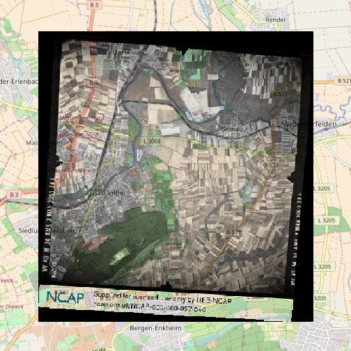
I am using QGis 2.18.7 and would like to open a jpg from ncap.org.uk: Here is the link to the image but one has to register in order to download the image: https://ncap.org.uk/frame/6-1-17-30-391 There is a jpg and a kml file for download. I put both in the same folder but I can not find a way to open the jpg in QGis.
1 Answer
The KML doesn't contain a "GroundOverlay" section so won't show the image mapped to the ground. It contains a single "Placemark" which has a point and four coordinates of a rectangle in lat-long, with the image being linked into the description. Hence in Google Earth it would show a single point and maybe the rectangle, and if you click it you'd get the image loaded in the popup window.
The coordinates give the lower left and upper right of the rectangle as:
        8.705740,50.150059,0
        8.814502,50.219701,0
but if I use the QGIS georeferencer to map the corner of the map part of the image I get very poor referencing to an underlying OpenStreetMap.
Its hard to georeference to ground points on OpenStreetMap because the area has changed so much, but using a few points on the river and railway I can see that the image isn't "North-up", but rotated by about ten degrees. Doing a full transform in QGIS Georeferencer results in a pretty good match:
The dark woodland area lower left is also still there, and good for georeference control points.
Edit: georeferencing to a Google Satellite Image layer works even better, because many of the field boundaries present in the image are still there in the Google Satellite layer. Many of the fields that seem to be "strip" farmed in the old image look to have been consolidated into single fields for modern farming practices.

