4

I am trying to use the advanced digitizing panel with a new line geometry layer. I am using QGIS 3.0.3

The QGIS documentation states:

"The tools are not enabled if the map view is in geographic coordinates"

But provides no information on how to set the "map view" to "geographic coordinates". When I attempt to use the advanced digitizing panel I am given a similar message, but with a bit more information "Change the coordinates system in the project". Yep, that's it, no information on how exactly to do that.

In CAD tools are not enabled for the current map tool the answer states that the panel works perfectly with "projected coordinates". I certainly believe this is true, but, once again, there is no information about HOW to switch to "projected coordinates".

BTW, I have searched the QGIS documentation, and there does not seem to be any reference to "geographic coordinate systems" or any instructions regarding them.

How do I change my project (or map view?) from "geographic coordinate system" to "projected coordinate system"?

1

3 Answers 3

4

To set the project coordinate system you should go to : Project > Project Properties... (or do Ctrl+Shift+P) and select the CRS tab (CRS stand for Coordinate Reference System) there you can choose between most of the different coordinate system (Geographic or Projected).

If you are not familiar with the difference between Geographic or Projected you should read this (from the qgis help), and you may want to ask another question about witch coordinate system is the most appropriate for your aim (dont forget to specify the location and the intended use of your data)

1
0

J.R's answer made the difference and I am now using the Advanced Digitizing Panel as I wanted. I am adding some more information that I learned along the way.

The Advanced Digitizing Panel only works when the Coordinate Reference System (CRS) being used by the project is a PROJECTED rather than a GEOGRAPHIC CRS. The reason for this is that advanced digitizing uses linear units of measure, such as feet or meters, which is more compatible with a projected, than with a geographic, CRS.

A geographic CRS utilizes angles (degrees latitude and longitude) to represent points on a surface, while a projected CRS utilizes linear measures (feet to the North or to the East of a reference point). The underlying math of a geographic CRS is essentially spherical geometry, while the projected CRS utilizes planar geometry.

Advanced digitization uses linear measures of distance and thus translates easily into the coordinates of a planar projection, whereas using linear measurements on a spherical surface is much more computationally difficult (trig!) and less intuitive. Even the angles used in advanced digitizing are planar, and are incompatible with angles on the surface of a sphere. For instance, the interior angles of a planar triangle sum to 180 degrees - but this is not true for a triangle on a spherical surface.

Because it is simpler, more intuitive, and probably actually what is wanted, advanced digitization is confined to projected (planar) CRSs and is not supported for geometric (spherical) CRSs.

How do you configure QGIS for a projected CRS, rather than a geometric CRS? The Project -> Project Properties -> CRS dialog is used to select a CRS for the project. The default QGIS CRS for a new project seems to be "WGS 84" which is a geometric CRS and advanced digitization will not work with it. The "Coordinate reference systems of the world" table in this dialog is a catalog of CRS's, many of which are projected rather than geometric. If you know which is which, you can select an appropriate projected CRS for your project. I do not know how to distinguish them.

1
  • That is all well and good, but it still doesn't really explain why the tool isn't enabled. Say you are working in WGS84 (EPSG:4326). You have a location (say from your GPS or even derived from Google Maps). You then use your compass and sight a location 5km away and with a bearing of 32° from North. While I can use plugin tools to measure the bearing angle or even use an expression to show azimuth it seems like a strange constraint in the advanced digitizing tool
    – martyvis
    Commented Sep 3, 2022 at 0:56
0

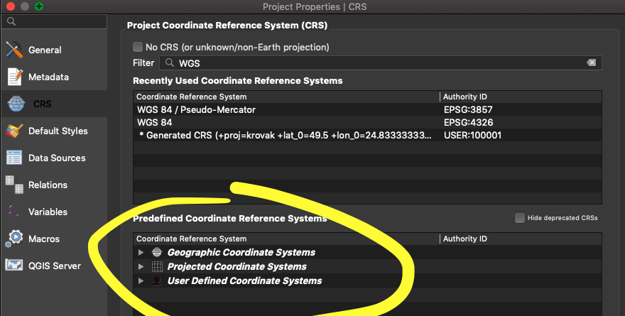
I would just add to this that to know which system is GEOGRAPHIC or PROJECTED in QGIS just go to pick project CRS window (Project -> Project Properties -> CRS) and then filter for desired CRS. List in Predefined Coordinate Reference Systems panel is divided into Geographic Coordinates Systems sublist, Projected Coordinate Systems sublist and User Defined Coordinate Systems sublist.

This is how you can pick PROJECTED system for your project.

enter image description here

Your Answer

By clicking “Post Your Answer”, you agree to our terms of service and acknowledge you have read our privacy policy.

Not the answer you're looking for? Browse other questions tagged or ask your own question.