2

I am trying to export dwg files in ArcGIS to a shapefile. My problem is that the y-coordinate is 500000 although it should be 3500000 because the dwg file is made to a coordinate system called Finnish Zone 3. So it is missing the zone number 3 which should be in the false easting value in that coordinate system.

How can I manually put the number 3 in the y-coordinate so that I can then easily project the file to EUREF-FIN and use that with other layers that are also in EUREF-FIN?

1

2 Answers 2

2

If the easting coordinate values of the the exported shapefile are relative to 500000, assign this coordinate system to the data:

PROJCS["Finland_Zone_3_modified",GEOGCS["GCS_KKJ",DATUM["D_KKJ",SPHEROID["International_1924",6378388.0,297.0]],PRIMEM["Greenwich",0.0],UNIT ["Degree",0.0174532925199433]],PROJECTION["Gauss_Kruger"],PARAMETER["False_Easting",500000.0],PARAMETER["False_Northing",0.0],PARAMETER ["Central_Meridian",27.0],PARAMETER["Scale_Factor",1.0],PARAMETER["Latitude_Of_Origin",0.0],UNIT["Meter",1.0],AUTHORITY["EPSG",2393]]

Save the string to an ASCII text file (use Notepad) as a single line. Save the file with a .prj extension. In ArcCatalog or the Define Projection Tool, import this file to use as the coordinate system. Then use the Project Tool to change it to use "Finland Zone 3".

Both of these definitions are based on the KKJ geographic coordinate reference system (datum).

0

A way to permanently create a coordinate system in ArcGIS is through the Coordinate System tab in your Data Frame properties. Right click on "Layers" or whatever the data frame is named in your Table of Contents, and select Properties. Click the "Coordinate System" tab to see whatever reference system the data frame is set to - presumably the EUREF-FIN/Finnish Zone 3 that you mentioned. If that's not the case, find this zone in the drop-down menus for Projected Coordinate Systems, and take note of the False Easting, False Northing, Central Meridian, Scale Factor, Latitude of Origin, and Linear Unit, as shown here (I have another projected CRS shown):
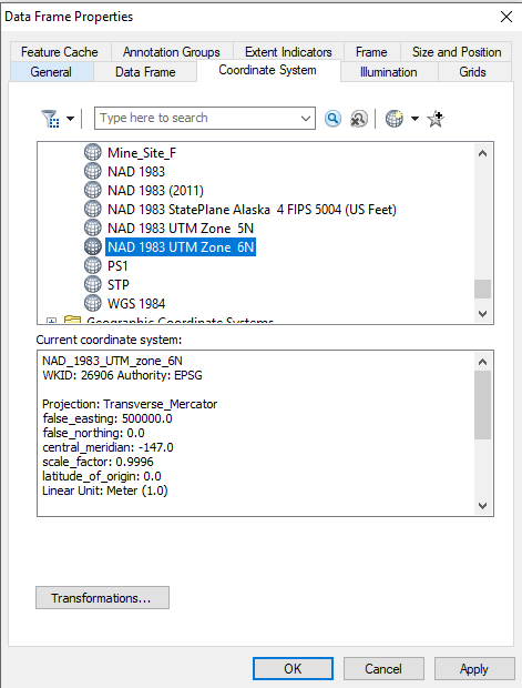
enter image description here

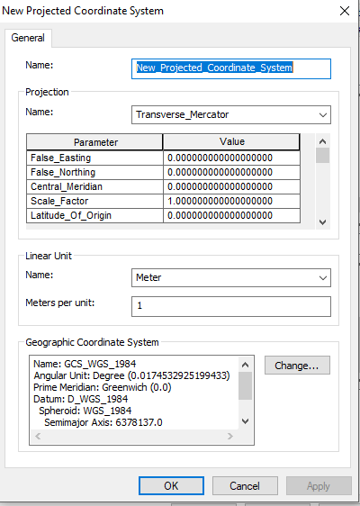
Also, take note of which Geographic Coordinate System this projected CRS is based on, after scrolling down. Then, click the Add Coordinate System in the upper part of the window to create a modified/new Projected Coordinate System:

enter image description here

Enter in the SAME EXACT VALUES copied from the projected system you want to modify, that is, the system you want to add 3,000,000 to the false easting. The one difference, of course, is that you want to set the False Easting to 3,500,000 - or whatever value it was, with 3,000,000 added. Save the reference system as whatever you want, and then select this new reference system for the Data Frame, and click OK to accept the changes to the data frame properties.

If you have "On the Fly Transformations" enabled, your layers should now be shifted with the change in Northing for the reference system. If not, you can use the Project (Data Management) tool and select this Coordinate System as the destination Coordinate System. After creating it, it will be saved with the existing Coordinate Systems in your working/AppData Esri folders.
enter image description here

2
  • There is an issue with this answer. OP uses y for easting and x for northing (ArcGIS ignores that), so the 3.5million is a false easting, not a false northing.
    – mkennedy
    Commented Jun 15, 2018 at 20:12
  • You're right - I was thrown by the "y value" in the question title.
    – AlecZ
    Commented Jun 15, 2018 at 23:37

Your Answer

By clicking “Post Your Answer”, you agree to our terms of service and acknowledge you have read our privacy policy.

Not the answer you're looking for? Browse other questions tagged or ask your own question.