1

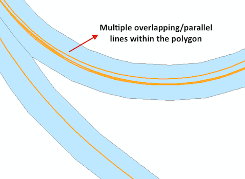
Is there a way to calculate the coverage of polylines within a polygon when there are overlapping lines and parallel lines?

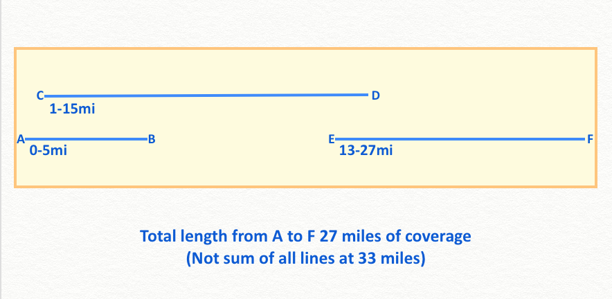
I am working on finding route coverage of gps traces within a centerline route buffer, but ran into the issue of having multiple traces that run alongside each other, overlap, or have gaps. The result is numerous short polylines within the route polygon and no way of calculating if the lines provide full coverage of the route extent. For example, I have a route polygon that is 27 miles long, and has 56 polylines within it and the sum of the lines are 126 miles.

I am using ArcMap 10.5, advanced license. I am not using Network Analyst or any other extensions. I am cutting gps traces to a buffer of a route centerline shapefile. The gps traces gets cut at the start and end of a route, I then calculate the length and mileage of the section via the m-values of the line. The issue is that there are numerous traces in each route polygon, and no way to find out if the length of the original route (polygon) is covered due to gaps in coverage and no continuous coverage of a single gps trace.

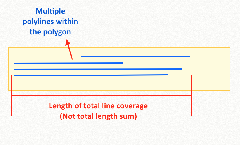
I am looking for coverage parallel to the X axes. So just the overall length coverage that the lines provide within the polygon, total length covered rather than total sum of all lines.

enter image description here

enter image description here

enter image description here

4
  • Are you using ArcGIS Network Analyst to calculate your routes? What is the precise workflow (all tools and parameter values) that you are using to try and do this? In your workflow where precisely do you get stuck? I suspect that a more simplified picture, and some tables might help clarify a single question that you wish to ask.
    – PolyGeo
    Commented Jun 17, 2018 at 23:06
  • What would you want to record under this scenario? Your route polygon is 27 miles. You have a gps track lets says starts at 0 miles and terminates at 10 miles. There is a 1 mile gap then a new gps tracks starts at 11 and terminates at 15 miles, Is is the maximum distance (15 miles) or the distance 14 miles? And what if there was a further GPS which starts at 13 miles and ends at 20? Edit your question to demonstrate what exactly the final answer you are seeking as I can read your question in one two ways.
    – Hornbydd
    Commented Jun 18, 2018 at 9:04
  • You might experiment with Integrate to snap the lines together, then Dissolve to merge the stacked lines into a single line.
    – klewis
    Commented Jun 19, 2018 at 21:11
  • @ klewis, this worked! I was able to get the total length of the line coverage, thanks!
    – Carrillo
    Commented Jun 20, 2018 at 20:07

1 Answer 1

1

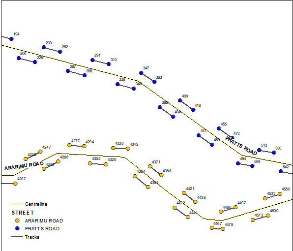
Perhaps create points at the ends of segments, compute their chainages along centre lines and summarize (min, max) them by line name. Difference is your coverage, providing there are no gaps similar to shown below, i.e. your picture shows typical situation:

enter image description here

2
  • Unfortunately there are gaps between some of the lines, and quite a few overlapping sections. I have tried summarizing the lines but get the total length of all the lines combined rather than the total length the lines cover within the polygon.
    – Carrillo
    Commented Jun 19, 2018 at 20:37
  • Think of my lines shown as projections of centre line. When I said gaps, I meant distances along the line, e.g. there is no gap between (4480,4497) and (4467, 4478) segments in lower right corner, because their projections overlap. Your pictures show absence of gaps.
    – FelixIP
    Commented Jun 19, 2018 at 22:59

Your Answer

By clicking “Post Your Answer”, you agree to our terms of service and acknowledge you have read our privacy policy.

Not the answer you're looking for? Browse other questions tagged or ask your own question.