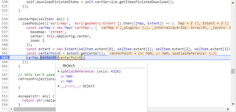
I'm working on a angular 2 website using the Arcgis API 3.24. I'm fairly new to ESRI and I was wondering how I could convert a extent that has values of
spatialReference :
    {wkid: 4326}
    xmax:
        "-106.477219"
    xmin :
        "-106.728864"
    ymax:
        "35.190922"
    ymin:
        "35.014214"
to a centerpoint x and y that I could center my map on?
My code:
setSelectedItem(selItem: any) {
  const self = this;
  loadModules(['esri/geometry/Extent', 'esri/SpatialReference', 'esri/symbols/SimpleLineSymbol', 'esri/graphic']).then(([Extent, SpatialReference, SimpleLineSymbol, Graphic]) => {
    const extent = new Extent(selItem.extent[0], selItem.extent[1], selItem.extent[2], selItem.extent[3], new SpatialReference({wkid: 4326}));
    self.isDrawToolVisible = selItem.useExtent;
    self.selectedItem = selItem;
    const color: any = '#004065';
    const symbol = new SimpleLineSymbol(SimpleLineSymbol.STYLE_SOLID, color, 4);
    self.extentLayer.clear();
    self.extentLayer.add(new Graphic(extent, symbol));
    if (self.cartMap.graphics) {
      self.cartMap.graphics.clear();
    }
    if (selItem.useExtent && selItem.clipGraphic) {
      self.cartMap.graphics.Add(selItem.clipGraphic);
    }


    self.downloadFinishedItems = self.cartService.getItemsFinishedDownload();
  });
}
UPDATE :
When I try to center the x and y return with NaN:

