I have a boundary polyline of an island that is broken into multiple short segments. The island is surround by many other islands. What I want to do is delete the mainland island and convert the satellite islands into polygons. I tried dissolve but that merged the entire file into one feature. I then tried the multipart to single part thinking it would separate the smaller islands from the large one but it broke the entire file back up into the short segments again. Effectively I want to merge/dissolve touching lines so that each individual island is its own, one line feature.
1 Answer
Depends on how your segments are "touching" each other, but one possiblity is Join multiple lines plugin.
It is a nice tool, but please use it attentively, because the input geometries are important.
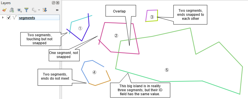
(1) Input
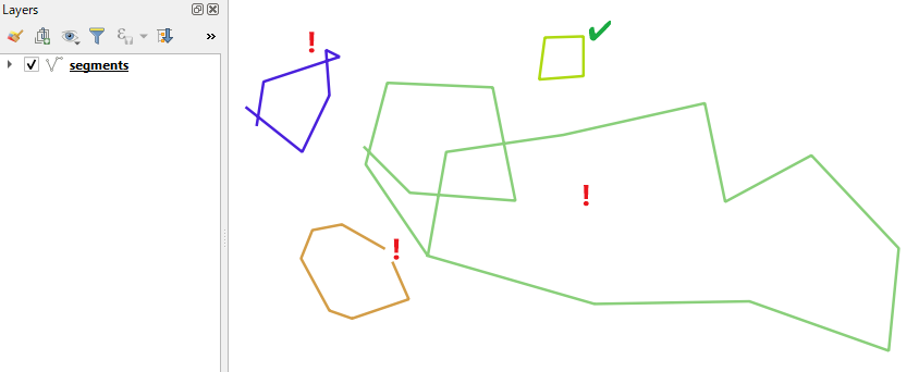
(2) Output
If the islands are like the No.3 above (segments are met at the end vertices) ,the tool successfully returns closed polygons. If not, the output will be usual "garbage in, garbage out".
-
I have thought about that tool but the layer is extremely complex. I suspect there are a couple of gaps and that is causing the polygonise tool to fail but I have no idea where they are and can't find them manually.– Ski nailCommented Jan 27, 2019 at 2:15
-
@Skinail If you want to discuss about Polygonize please address it to Jochen. (Start ID with @ mark will send your comment to Inbox).– KazuhitoCommented Jan 27, 2019 at 12:56


