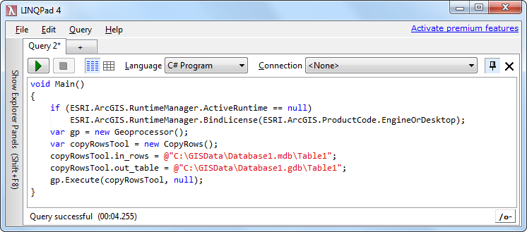
I do this... but its probably not the greatest approach
   public bool CreateFileGDB(ref string error, string fullshapefilepath, String shapeFileDirectory, String shapeFileName, string badfields, ShapefileType shapefiletype, string Style )
        {
            try
            {
                string projectionfile = fullshapefilepath.ToUpper().Replace(".SHP", ".PRJ");
                string dbffile = fullshapefilepath.ToUpper().Replace(".SHP", ".DBF");

                ISpatialReference spREF = null;
                if (File.Exists(projectionfile))
                    spREF = MapLibrary.Get().srFactory.CreateESRISpatialReferenceFromPRJFile(projectionfile);
                else  //assume standard coords
                    spREF = MapLibrary.Get().standardSpatialReference;

                string GDBPath = shapeFileDirectory + shapeFileName.Replace(".shp", ".gdb");

                if (!Directory.Exists(GDBPath))
                {
                    string InputFields = badfields;

                    string RequiredFields = string.Empty;
                    if (shapefiletype == ShapefileType.Point || shapefiletype == ShapefileType.Polygon)
                        RequiredFields = US_One_Address_with_Zone_Required_Fields;
                    else
                        RequiredFields = US_Streets_with_City_State_ZIP;

                    string[] input = InputFields.Split(splitter);
                    string[] output = RequiredFields.Split(splitter, StringSplitOptions.RemoveEmptyEntries);

                    ESRI.ArcGIS.Geodatabase.IWorkspaceFactory pWorkspaceFactory = new FileGDBWorkspaceFactoryClass();
                    string dir = string.Empty;
                    string filename = string.Empty;
                    Util.GetDirectoryFileName(GDBPath, ref dir, ref filename);

                    //input
                    IWorkspaceName pInShpWorkspaceName = new WorkspaceNameClass() as IWorkspaceName;
                    pInShpWorkspaceName.PathName = shapeFileDirectory;
                    pInShpWorkspaceName.WorkspaceFactoryProgID = "esriCore.ShapefileWorkspaceFactory";
                    IFeatureClassName pFCName = new FeatureClassNameClass() as IFeatureClassName;
                    IDatasetName pShpDatasetName = pFCName as IDatasetName;
                    pShpDatasetName.Name = shapeFileName;//this is your input file
                    pShpDatasetName.WorkspaceName = pInShpWorkspaceName;
                    IName sourceName = (IName)pFCName;
                    IFeatureClass sourceFeatureClass = (IFeatureClass)sourceName.Open(); //fails
                    IFields sourceFields = sourceFeatureClass.Fields;
                    List<string> fieldnames = GetFieldNames(sourceFields);

                    //output
                    IWorkspaceName pWorkspaceName = new WorkspaceNameClass() as IWorkspaceName;
                    pWorkspaceName.WorkspaceFactoryProgID = "esriDataSourcesGDB.FileGDBWorkspaceFactory";
                    pWorkspaceName.PathName = GDBPath; //output file
                    IFeatureClassName pOutputFC = new FeatureClassNameClass();
                    IDatasetName pDataSetName = pOutputFC as IDatasetName;
                    pDataSetName.WorkspaceName = pWorkspaceName;
                    pDataSetName.Name = "Streets";
                    IFeatureDataConverter pShpToFc = new FeatureDataConverterClass();


                    for (int i = 0; i < input.Length; i++)
                        RenameColumn(sourceFields, input[i], output[i]);


                    List<string> newfieldnames = GetFieldNames(sourceFields);

                    if(shapefiletype == ShapefileType.Point)
                    {
                        IGeometryDef def = Create_IGeometryDef(spREF, esriGeometryType.esriGeometryPoint);
                        pShpToFc.ConvertFeatureClass(pFCName, null, null, pOutputFC, def, sourceFields, "", 1000, 0);
                    }
                    else if(shapefiletype == ShapefileType.Polygon)
                    {
                        IGeometryDef def = Create_IGeometryDef(spREF, esriGeometryType.esriGeometryPolygon);
                        pShpToFc.ConvertFeatureClass(pFCName, null, null, pOutputFC, def, sourceFields, "", 1000, 0);
                    }
                    else if (shapefiletype == ShapefileType.Polyline)
                    {
                        IGeometryDef def = Create_IGeometryDef(spREF, esriGeometryType.esriGeometryPolyline);
                        pShpToFc.ConvertFeatureClass(pFCName, null, null, pOutputFC, def, sourceFields, "", 1000, 0);
                    }
                    else
                        pShpToFc.ConvertFeatureClass(pFCName, null, null, pOutputFC, null, sourceFields, "", 1000, 0);
                }

                return true;
            }

