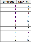
I am trying to sum up the cells of a raster that fall within a polygon of multiple habitat types and ten management authority zones. Is there a way for Zonal Statistics As Table in ArcMap 10.5 to use both the habitat type (gridcode) and the management authority (CMA_NO) as the Zone Fields (see image below)? I could split up the polygon into ten separate polygons, one for each management authority, then rejoin all the tables at the end, but I have about 50 rasters I need to do this for, so I would like to find some way of minimizing the number of steps.
1 Answer
Create a new column that contains a unique value for each gridcode-CMA_NO pair. For example you could use Calculate Field and set the output to "gridcode" + "_" + ""CMA_NO" so that the first column would result in a text value of "1_7". Then you can use this newly created column as your zone.

