I have 20 trajectories
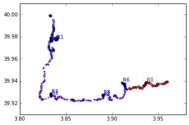
I found a method on Github https://github.com/wisaaco/MatchGPX. The method's output is shown below. There are two GPS traces one in blue and other in Red.
The overlapping portion is marked with + and based on the continuity different regions R1, R2- R6 have been created. I have more than two GPS trajectories and what I want to do is identify regions similar as in the image and clip the data belonging different trajectories

GPS accuracy : 3m
I see Vector Overlay and clipping in this tutorial https://docs.qgis.org/3.10/en/docs/user_manual/processing_algs/qgis/vectoroverlay.html#id32
