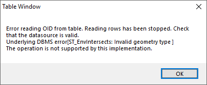
I have a GeoPackage database with a few layers inside of it. One layer, which has about 1000 records, some complex geometry, but no relationships, would not open correctly in ArcMap (specifically ArcMap 10.3.1) with the error being as per screen grab (which occurs during browsing of the attribute table)
Error Message reads:
Error reading OID from table. Reading rows has been stopped.Check that the datasource is valid. Underlying DMS Error[ST_EnvIntersects: Invalid Geometry type] The operation is not support by this implementation.
However, the Geopackage is geometrically compliant inside of QGIS and other open source geometry validation tools (check validity as an example). Interestingly, ArcGIS Pro 2.2.0 has no problem reading the Geopackage.
Should I investigate the data further becuase ArcMap is telling me its invalid or does the QGIS OGC geometric checking tools (And ArcGIS Pro) give me enough confidence to know the geometry is valid?

