31

I am putting together a GIS server using GeoServer and need some help with importing my layer styles from ArcGIS 10 to SLD format.

I have one layer in ArcMap properly symbolized and labeled, how can I get this layers symbolization and labeling into a SLD file?

5 Answers 5

17

Arc2Earth

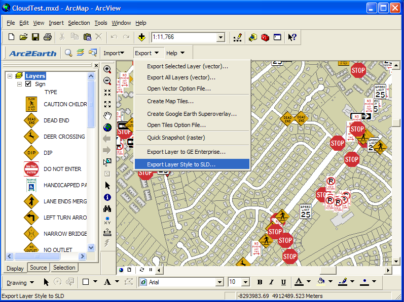
The Community Edition can only export single layers, you'll need to upgrade to Pro if you want create a single SLD file for your entire Map. After your selection, click on the Export button and you will be asked for a location to export to.

alt text

http://help.arc2earth.com/help/faqs/arc2earth-desktop/export-map-symbols-to-styled-layer-descriptor-sld

6
  • I have it installed and the MXD I am using has 1 layer on it, whenever I try the Export Single Layer option the drop down menu is blank, any ideas?
    – Furlong
    Commented Nov 29, 2010 at 20:54
  • EDIT: Never mind, I just got it to work!
    – Furlong
    Commented Nov 29, 2010 at 21:17
  • 2
    Seems like Community Edition was killed and there is only paid version.
    – Miro
    Commented Jul 3, 2014 at 0:18
  • 1
    Current Arc2Earth Lite users will have until June 1st, 2014 to upgrade to a full subscription. So no fun anymore.
    – Miro
    Commented Jul 3, 2014 at 0:27
  • 2
    Arc2Earth is closed for business, so this answer no longer helps.
    – Mike T
    Commented Jul 7, 2020 at 9:46
8

I was looking for the same thing just the other day and found this http://wald.intevation.org/projects/arcmap2sld/. I haven't tried it yet though so will be interested to hear if you do.

As noted by @AlexTereshenkov in a comment there is also a version for ArcGIS Desktop 10 - see bottom of the A tool for reading out styling information from ArcMap® and converting into Styled Layer Descriptor-Files (SLD) of OGC page.

6
  • Found this works for ArcGIS 9.3 but not ArcGIS 10. Furlong was looking for ArcGIS 10 solution. But yes a valid project that needs an update.
    – Mapperz
    Commented Nov 23, 2010 at 14:57
  • Does arcmap2sld work for ArcGIS 10?
    – Matt
    Commented Dec 15, 2010 at 19:11
  • 2
    Unfortunately, the ArcMap2SLD Converter only works in ArcGIS 10.0, not in later versions such as 10.2 Also, Arc2Earth has deprecated their "lite" version.
    – mike
    Commented Sep 24, 2014 at 17:34
  • 2
    ArcMap2SLD now supports ArcMap up to 10.5. More details here: arcmap2sld.i3mainz.hs-mainz.de/Dateianlagen/readme_english.txt . It can be downloaded from wald.intevation.org/frs/?group_id=32
    – Ernesto561
    Commented Jul 27, 2017 at 16:29
  • 1
    Tested in 10.7 - seems to work fine
    – Tom
    Commented Feb 29, 2020 at 13:15
6

I have confirmed that arcmap2sld tool is working fine on ArcGIS Desktop 10.1+. The program can be downloaded from this link and the readme docs are here.

The program transforms an ArcMap project's layers symbology into an .sld document which can be used in open-source software. It is implemented in Visual Basic .NET and requires .NET 2.0.

The steps:

  1. Unpack the .zip file.
  2. Run the "\stp\Adjust_for_ArcGIS-version.bat" file which creates the configuration file ArcGIS_SLD_Converter.exe.config in the current folder. This configuration contains the metadata on ArcGIS system libraries available in your installation.
  3. Run the ArcGIS_SLD_Converter.exe to start the program.

To be able to create .sld files, you need to have ArcMap application started with some layers added. So you add your feature classes to ArcMap, set the symbology needed and then use the ArcGIS_SLD_Converter to export each of the layers' symbology into a .sld file on disk. You can specify whether you want to export all layers into a single .sld file or into individual files (Extras menu > Layers).

There are certain limitations with regards to what type of symbology could be exported. Having a picture symbol will throw an error when trying to convert; some other symbols such as dashed line, will be downgraded into solid lines. You might want to experiment to see what symbology is supported.

0
4

The best solution I've seen for arcgis to sld conversion is GeoCat Bridge. It's not free, but then again neither is ArcGIS 10. It'll publish directly to your GeoServer, using its REST config API (and also stick your metadata on GeoNetwork).

0

There is SLD Converter for ArcGIS for 10.0. I've not tested it as I cannot read the Korean text so have no means to vet for authenticity etc. Perhaps someone here can do that.

Found by way of comments to Converting an ArcMap layer file into an SLD document (2012).

Your Answer

By clicking “Post Your Answer”, you agree to our terms of service and acknowledge you have read our privacy policy.

Not the answer you're looking for? Browse other questions tagged or ask your own question.