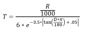
I am trying to convert a slope raster to a friction surface with values based on Tobler's Hiking Function in ArcGIS Pro, but I get an error message I am not sure is about the formula syntax or file/path names. I first converted a DEM of part of the Florida coast with a 5-meter cell size and elevation units in centimeters to a slope raster with a Z-factor of 0.01 because I believe I had to convert centimeters (vertical units) to meters (horizontal units). When the Z-factor was 1 most of the land, including the coastline, had values greater than 45 degrees. Other than roads and reservoirs the slope raster is very flat but I would expect that for Florida.
Error:
 ERROR 000539: Traceback (most recent call last):
  File "<expression>", line 1, in <module>
  File "<string>", line 8, in rcexec_DC684390_0C54_4F14_9EBF_B34DF3F2E1B1
RuntimeError:  ERROR 010240: Could not save raster dataset to cm5_fl7_hike.tif with output format FGDBR.
 Failed to execute (RasterCalculator).
Parameters:
Map algebra expression:  (5.0 / 1000) / (6 * Exp(-3.5 * Abs(Tan(("DEMs\5M\cm5_fl7_slopem.tif" * 3.14159) / 180) + .05)))

Output raster: d:\FLGIS\Lidar\Lidar.gdb\cm5_fl7_hike.tif
I am trying to replicate the following mathematical formula which was typed exactly as it was written in an article guide
