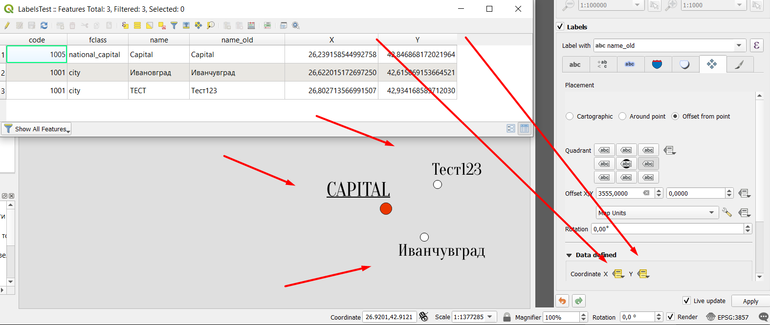
In QGIS both in line, point and polygon type layers (for rivers, settlements, lakes..) I created labels for the objects - I created a field X and Y (Decimal Number), so that I define their location (look at picture) - manually. Basically I move every label separately from one another, and that label has it's specific coordinates. This is 2 years work now, so the new QGIS easy-fast option for manually moving labels was not yet created.
Now the question is this:
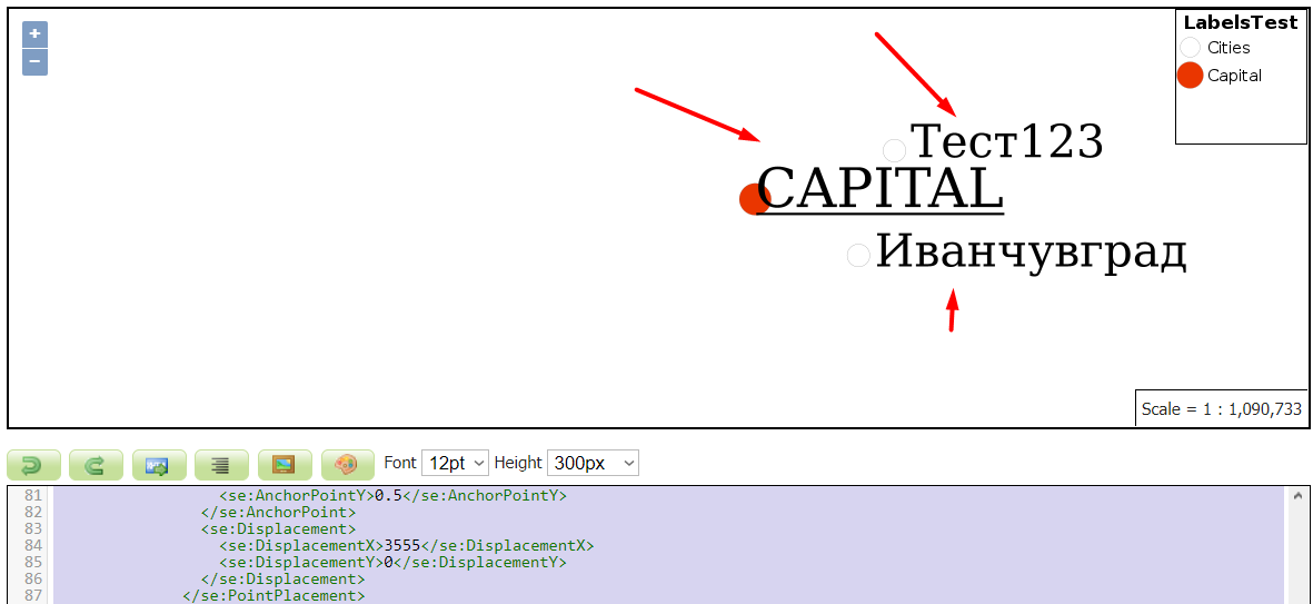
I invested a lot time now and I can not find a solution, inside or outside GeoServer documentation - I use SLD style export for all of the layers in GeoServer, that I have no problems styling. However, I can not find a way to style the labels as such different positions, that they are visualized for every specific location with X and Y in GeoServer. So I can not get the same result that I have in QGIS - in GeoServer. I manage to use all of the other SLD styles - so that they are offset from the point in many different ways, but every single label is offest the same way as the others.
Here are 2 SLD examples for point type that is exported from QGIS where I use this manual placement of labels. . 1 Is the basic one, pure export from QGIS. But it won't load, because of map units. So >>2>> fixed one>> 2 Is modiffied with a line or two,so that it works - because of map units and projection.
And in the end, I show you a picture: How all 3 labels in GeoServer are on the right.
1 ORIGINAL ONE
<StyledLayerDescriptor xmlns="http://www.opengis.net/sld" version="1.1.0" xmlns:xsi="http://www.w3.org/2001/XMLSchema-instance" xmlns:se="http://www.opengis.net/se" xsi:schemaLocation="http://www.opengis.net/sld http://schemas.opengis.net/sld/1.1.0/StyledLayerDescriptor.xsd" xmlns:xlink="http://www.w3.org/1999/xlink" xmlns:ogc="http://www.opengis.net/ogc">
  <NamedLayer>
    <se:Name>LabelsTest</se:Name>
    <UserStyle>
      <se:Name>LabelsTest</se:Name>
      <se:FeatureTypeStyle>
        <se:Rule>
          <se:Name>Cities</se:Name>
          <se:Description>
            <se:Title>Cities</se:Title>
          </se:Description>
          <ogc:Filter xmlns:ogc="http://www.opengis.net/ogc">
            <ogc:PropertyIsEqualTo>
              <ogc:PropertyName>code</ogc:PropertyName>
              <ogc:Literal>1001</ogc:Literal>
            </ogc:PropertyIsEqualTo>
          </ogc:Filter>
          <se:PointSymbolizer uom="http://www.opengeospatial.org/se/units/metre">
            <se:Graphic>
              <se:Mark>
                <se:WellKnownName>circle</se:WellKnownName>
                <se:Fill>
                  <se:SvgParameter name="fill">#ffffff</se:SvgParameter>
                </se:Fill>
                <se:Stroke>
                  <se:SvgParameter name="stroke">#000000</se:SvgParameter>
                  <se:SvgParameter name="stroke-width">0.5</se:SvgParameter>
                </se:Stroke>
              </se:Mark>
              <se:Size>4999.1999999999998181</se:Size>
            </se:Graphic>
          </se:PointSymbolizer>
        </se:Rule>
        <se:Rule>
          <se:Name>Capital</se:Name>
          <se:Description>
            <se:Title>Capital</se:Title>
          </se:Description>
          <ogc:Filter xmlns:ogc="http://www.opengis.net/ogc">
            <ogc:PropertyIsEqualTo>
              <ogc:PropertyName>fclass</ogc:PropertyName>
              <ogc:Literal>national_capital</ogc:Literal>
            </ogc:PropertyIsEqualTo>
          </ogc:Filter>
          <se:PointSymbolizer uom="http://www.opengeospatial.org/se/units/metre">
            <se:Graphic>
              <se:Mark>
                <se:WellKnownName>circle</se:WellKnownName>
                <se:Fill>
                  <se:SvgParameter name="fill">#ea3600</se:SvgParameter>
                </se:Fill>
                <se:Stroke>
                  <se:SvgParameter name="stroke">#232323</se:SvgParameter>
                  <se:SvgParameter name="stroke-width">0.5</se:SvgParameter>
                </se:Stroke>
              </se:Mark>
              <se:Size>7000</se:Size>
            </se:Graphic>
          </se:PointSymbolizer>
        </se:Rule>
        <se:Rule>
          <ogc:Filter xmlns:ogc="http://www.opengis.net/ogc">
            <ogc:PropertyIsEqualTo>
              <ogc:PropertyName>fclass</ogc:PropertyName>
              <ogc:Literal>city</ogc:Literal>
            </ogc:PropertyIsEqualTo>
          </ogc:Filter>
          <se:TextSymbolizer>
            <se:Label>
              <ogc:PropertyName>name_old</ogc:PropertyName>
            </se:Label>
            <se:Font>
              <se:SvgParameter name="font-family">Oranienbaum</se:SvgParameter>
              <se:SvgParameter name="font-size">10000</se:SvgParameter>
            </se:Font>
            <se:LabelPlacement>
              <se:PointPlacement>
                <se:AnchorPoint>
                  <se:AnchorPointX>0</se:AnchorPointX>
                  <se:AnchorPointY>0.5</se:AnchorPointY>
                </se:AnchorPoint>
                <se:Displacement>
                  <se:DisplacementX>3555</se:DisplacementX>
                  <se:DisplacementY>0</se:DisplacementY>
                </se:Displacement>
              </se:PointPlacement>
            </se:LabelPlacement>
            <se:Fill>
              <se:SvgParameter name="fill">#000000</se:SvgParameter>
            </se:Fill>
            <se:VendorOption name="conflictResolution">false</se:VendorOption>
          </se:TextSymbolizer>
        </se:Rule>
        <se:Rule>
          <ogc:Filter xmlns:ogc="http://www.opengis.net/ogc">
            <ogc:PropertyIsEqualTo>
              <ogc:PropertyName>fclass</ogc:PropertyName>
              <ogc:Literal>national_capital</ogc:Literal>
            </ogc:PropertyIsEqualTo>
          </ogc:Filter>
          <se:TextSymbolizer>
            <se:Label>
              <ogc:Function name="strToUpperCase">
                <ogc:PropertyName>name_old</ogc:PropertyName>
              </ogc:Function>
            </se:Label>
            <se:Font>
              <se:SvgParameter name="font-family">Oranienbaum</se:SvgParameter>
              <se:SvgParameter name="font-size">12000</se:SvgParameter>
            </se:Font>
            <se:LabelPlacement>
              <se:PointPlacement>
                <se:AnchorPoint>
                  <se:AnchorPointX>0</se:AnchorPointX>
                  <se:AnchorPointY>0.5</se:AnchorPointY>
                </se:AnchorPoint>
              </se:PointPlacement>
            </se:LabelPlacement>
            <se:Fill>
              <se:SvgParameter name="fill">#000000</se:SvgParameter>
            </se:Fill>
            <se:VendorOption name="underlineText">true</se:VendorOption>
            <se:VendorOption name="conflictResolution">false</se:VendorOption>
          </se:TextSymbolizer>
        </se:Rule>
      </se:FeatureTypeStyle>
    </UserStyle>
  </NamedLayer>
</StyledLayerDescriptor>
2 CHANGED ONE so it loads (of map units)
<StyledLayerDescriptor xmlns="http://www.opengis.net/sld" version="1.1.0" xmlns:xsi="http://www.w3.org/2001/XMLSchema-instance" xmlns:se="http://www.opengis.net/se" xsi:schemaLocation="http://www.opengis.net/sld http://schemas.opengis.net/sld/1.1.0/StyledLayerDescriptor.xsd" xmlns:xlink="http://www.w3.org/1999/xlink" xmlns:ogc="http://www.opengis.net/ogc">
  <NamedLayer>
    <se:Name>LabelsTest</se:Name>
    <UserStyle>
      <se:Name>LabelsTest</se:Name>
      <se:FeatureTypeStyle>
        <se:Rule>
          <se:Name>Cities</se:Name>
          <se:Description>
            <se:Title>Cities</se:Title>
          </se:Description>
          <ogc:Filter xmlns:ogc="http://www.opengis.net/ogc">
            <ogc:PropertyIsEqualTo>
              <ogc:PropertyName>code</ogc:PropertyName>
              <ogc:Literal>1001</ogc:Literal>
            </ogc:PropertyIsEqualTo>
          </ogc:Filter>
          <se:PointSymbolizer uom="http://www.opengeospatial.org/se/units/metre">
            <se:Graphic>
              <se:Mark>
                <se:WellKnownName>circle</se:WellKnownName>
                <se:Fill>
                  <se:SvgParameter name="fill">#ffffff</se:SvgParameter>
                </se:Fill>
                <se:Stroke>
                  <se:SvgParameter name="stroke">#000000</se:SvgParameter>
                  <se:SvgParameter name="stroke-width">0.5</se:SvgParameter>
                </se:Stroke>
              </se:Mark>
              <se:Size>4999.1999999999998181</se:Size>
            </se:Graphic>
          </se:PointSymbolizer>
        </se:Rule>
        <se:Rule>
          <se:Name>Capital</se:Name>
          <se:Description>
            <se:Title>Capital</se:Title>
          </se:Description>
          <ogc:Filter xmlns:ogc="http://www.opengis.net/ogc">
            <ogc:PropertyIsEqualTo>
              <ogc:PropertyName>fclass</ogc:PropertyName>
              <ogc:Literal>national_capital</ogc:Literal>
            </ogc:PropertyIsEqualTo>
          </ogc:Filter>
          <se:PointSymbolizer uom="http://www.opengeospatial.org/se/units/metre">
            <se:Graphic>
              <se:Mark>
                <se:WellKnownName>circle</se:WellKnownName>
                <se:Fill>
                  <se:SvgParameter name="fill">#ea3600</se:SvgParameter>
                </se:Fill>
                <se:Stroke>
                  <se:SvgParameter name="stroke">#232323</se:SvgParameter>
                  <se:SvgParameter name="stroke-width">0.5</se:SvgParameter>
                </se:Stroke>
              </se:Mark>
              <se:Size>7000</se:Size>
            </se:Graphic>
          </se:PointSymbolizer>
        </se:Rule>
        <se:Rule>
          <ogc:Filter xmlns:ogc="http://www.opengis.net/ogc">
            <ogc:PropertyIsEqualTo>
              <ogc:PropertyName>fclass</ogc:PropertyName>
              <ogc:Literal>city</ogc:Literal>
            </ogc:PropertyIsEqualTo>
          </ogc:Filter>
          <se:TextSymbolizer uom="http://www.opengeospatial.org/se/units/metre">
            <se:Label>
              <ogc:PropertyName>name_old</ogc:PropertyName>
            </se:Label>
            <se:Font>
              <se:SvgParameter name="font-family">Oranienbaum</se:SvgParameter>
              <se:SvgParameter name="font-size">10000</se:SvgParameter>
            </se:Font>
            <se:LabelPlacement>
              <se:PointPlacement>
                <se:AnchorPoint>
                  <se:AnchorPointX>0</se:AnchorPointX>
                  <se:AnchorPointY>0.5</se:AnchorPointY>
                </se:AnchorPoint>
                <se:Displacement>
                  <se:DisplacementX>3555</se:DisplacementX>
                  <se:DisplacementY>0</se:DisplacementY>
                </se:Displacement>
              </se:PointPlacement>
            </se:LabelPlacement>
            <se:Fill>
              <se:SvgParameter name="fill">#000000</se:SvgParameter>
            </se:Fill>
            <se:VendorOption name="conflictResolution">false</se:VendorOption>
          </se:TextSymbolizer>
        </se:Rule>
        <se:Rule>
          <ogc:Filter xmlns:ogc="http://www.opengis.net/ogc">
            <ogc:PropertyIsEqualTo>
              <ogc:PropertyName>fclass</ogc:PropertyName>
              <ogc:Literal>national_capital</ogc:Literal>
            </ogc:PropertyIsEqualTo>
          </ogc:Filter>
          <se:TextSymbolizer uom="http://www.opengeospatial.org/se/units/metre">
            <se:Label>
              <ogc:Function name="strToUpperCase">
                <ogc:PropertyName>name_old</ogc:PropertyName>
              </ogc:Function>
            </se:Label>
            <se:Font>
              <se:SvgParameter name="font-family">Oranienbaum</se:SvgParameter>
              <se:SvgParameter name="font-size">12000</se:SvgParameter>
            </se:Font>
            <se:LabelPlacement>
              <se:PointPlacement>
                <se:AnchorPoint>
                  <se:AnchorPointX>0</se:AnchorPointX>
                  <se:AnchorPointY>0.5</se:AnchorPointY>
                </se:AnchorPoint>
              </se:PointPlacement>
            </se:LabelPlacement>
            <se:Fill>
              <se:SvgParameter name="fill">#000000</se:SvgParameter>
            </se:Fill>
            <se:VendorOption name="underlineText">true</se:VendorOption>
            <se:VendorOption name="conflictResolution">false</se:VendorOption>
          </se:TextSymbolizer>
        </se:Rule>
      </se:FeatureTypeStyle>
    </UserStyle>
  </NamedLayer>
</StyledLayerDescriptor>
I link a sample point lable file, styles and pictures.
[Sample point shapefile - styled. Same style is in SLD above](https://dox.abv.bg/download?id=35498f44f2# - Линк за сваляне)


