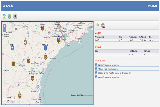
In my case, I found this solution to updating features. It's working very well:
1) In javascript I create a refresh method in every 5 seconds:
window.setInterval(loadUnits, 5000);
2) Create the layer :
function createUnitsLayer() {
    var def_style = new OpenLayers.Style({
        pointRadius : "${size}",
        fillOpacity: 0.5,
    });
    var sel_style = new OpenLayers.Style({
        fillOpacity: 1
    });
    var styleMap = new OpenLayers.StyleMap({"default" : def_style, "select": sel_style});
    unitsLayer = new OpenLayers.Layer.Vector("Units",  {styleMap: styleMap} );
    map.addLayer(unitsLayer);
}
Note the unitsLayer variable is global and declared in beginning of script.
3) Now, we fill the unitsLayer with the features. These come from a AJAX request. Call this after create the map and vector, so we have the initial positions, and every 5 seconds they will be refreshed.
function loadUnits() {
    var mapbounds = map.getExtent();
    mapbounds.transform(toProjection, fromProjection );
    bbox = mapbounds.toArray();
    var bleft = bbox[0];
    var bbottom = bbox[1];
    var bright = bbox[2];
    var btop = bbox[3];
    showLoader();
    var sourceURL = "getUnits?bleft=" + bleft + "&bbottom=" + bbottom + "&bright=" + bright + "&btop=" + btop;
    $.ajax({
            url: sourceURL,
            dataType: "json"
    }).done(function(data) {
        data = eval( data );
        var geojson_format = new OpenLayers.Format.GeoJSON({
            'internalProjection': map.baseLayer.projection,
            'externalProjection': new OpenLayers.Projection("EPSG:4326")
        });
        unitsLayer.removeAllFeatures();
        unitsLayer.addFeatures(geojson_format.read(data));
    });
}
This is a simple jQuery ajax request ( you will need the jQuery libs )
Here I set a bounding box from the map's viewport and send this to my ajax responder.
If is not your case, just ignore my projection transform.
Then, I remove all features from unitsLayer and add the new that came from ajax (expected a json format).
This is the expected json :
{"type":"FeatureCollection","features":[{"type":"Feature","properties":{"name":"TRON-02","serial":"TRON002","bearing":0,"color":"green","velocity":0.0,"size":15,"image":"img/unit_map3.png","pin_image":"img/pins/me/army.png","strength":0.0,"range":0.0},"geometry":{"type":"Point","coordinates":[-50.06542968749966,-23.749149728383717]}},{"type":"Feature","properties":{"name":"Magno","serial":"MAGNO","bearing":0,"color":"green","velocity":0.0,"size":15,"image":"img/unit_map3.png","pin_image":"img/pins/me/army.png","strength":0.0,"range":0.0},"geometry":{"type":"Point","coordinates":[-51.13659667968737,-25.228796984436144]}},{"type":"Feature","properties":{"name":"Flynn-01","serial":"FLYNN001","bearing":141,"color":"green","velocity":0.0,"size":15,"image":"img/unit_map3.png","pin_image":"img/pins/me/army.png","strength":0.0,"range":0.0},"geometry":{"type":"Point","coordinates":[-49.45019531249952,-26.769155570541734]}},{"type":"Feature","properties":{"name":"Stu-01","serial":"STU001","bearing":0,"color":"green","velocity":0.0,"size":15,"image":"img/unit_map3.png","pin_image":"img/pins/me/army.png","strength":0.0,"range":0.0},"geometry":{"type":"Point","coordinates":[-50.9443359374996,-26.29735617905113]}},{"type":"Feature","properties":{"name":"TRON-01","serial":"TRON001","bearing":124,"color":"green","velocity":0.0,"size":15,"image":"img/unit_map3.png","pin_image":"img/pins/me/army.png","strength":0.0,"range":0.0},"geometry":{"type":"Point","coordinates":[-49.603720399842345,-24.66298243986192]}},{"type":"Feature","properties":{"name":"Flynn-06","serial":"FLYNN006","bearing":0,"color":"green","velocity":0.0,"size":15,"image":"img/unit_map3.png","pin_image":"img/pins/me/army.png","strength":0.0,"range":0.0},"geometry":{"type":"Point","coordinates":[-48.016479492187294,-23.103987753888838]}}]}
To see well formated array you can copy and paste the data here .
My ajax provider is a Java struts2 action using the Google Json library to transform a simple java bean in json.
This is the result :


