I have a problem with the grassplugin in QGIS 3.22.2 Białowieża.
When I try to use the v.net.alloc (and other grass-tools) from the Processing Toolbox in the standalone QGIS 3.22.2 I get this error:
Starting GRASS GIS...
         WARNING: Concurrent mapset locking is not supported on Windows

         Cleaning up temporary files...

         access: No such file or directory

         ERROR: LOCATION not available

         Executing ...


         C:\Users\(...)\Desktop>chcp 1252 1>NUL


         C:\Users\(...)\Desktop>g.proj -c wkt="C:/Users/(...)/AppData/Local/Temp/processing_kpDgte/72ecb67feef54867a8ffc9851f208d7c/crs.prj"

         ERROR: Unable to open file 'C:/Users/(...)/AppData/Local/Temp/processing_kpDgte/72ecb67feef54867a8ffc9851f208d7c/crs.prj' for reading


         C:\Users\(...)\Desktop>v.external input="C:\Users\(...)\Documents\QGIS 3.22.2\Filer\NoWeRoadsClip.gpkg" layer="NoWeRoadsClip" output="vector_61fcfbdc824465" --overwrite -o

         access: No such file or directory

         ERROR: LOCATION not available


         C:\Users\(...)\Desktop>v.external input="C:\Users\(...)\AppData\Local\Temp\processing_kpDgte\338535ea2f794f34aa5335eed3b3b187\points.shp" output="vector_61fcfbdc8ac636" --overwrite -o

         access: No such file or directory

         ERROR: LOCATION not available


         C:\Users\(...)\Desktop>g.region n=3.85878803973861 s=1.67431656130019 e=33.4332991925107 w=30.7408159002858

         access: No such file or directory

         ERROR: LOCATION not available


         C:\Users\(...)\Desktop>v.net -s input=vector_61fcfbdc824465 points=vector_61fcfbdc8ac636 output=net61fcfbdc8b4307 operation=connect threshold=50.0

         access: No such file or directory

         ERROR: LOCATION not available


         C:\Users\(...)\Desktop>v.db.connect -o map=net61fcfbdc8b4307 table=vector_61fcfbdc8ac636 layer=2

         access: No such file or directory

         ERROR: LOCATION not available


         C:\Users\(...)\Desktop>v.net.alloc input=net61fcfbdc8b4307 center_cats="1-100000" arc_type="line,boundary" method="from" output=outputb1bc55ad8d224638b8fd52cf3e777071 --overwrite

         access: No such file or directory

         ERROR: LOCATION not available


         C:\Users\(...)\Desktop>v.out.ogr type="line" input="outputb1bc55ad8d224638b8fd52cf3e777071" output="C:/Users/(...)/AppData/Local/Temp/processing_kpDgte/863fe868de224291809e7b8d459c9f4c/output.gpkg" format="GPKG" layer=1 --overwrite

         access: No such file or directory

         ERROR: LOCATION not available


         C:\Users\(...)\Desktop>exit

         Execution of finished.

         Cleaning up temporary files...

         access: No such file or directory

         ERROR: LOCATION not available
I have also installed the OSGeo4W version and used the the qgis.bat file, which was recommended in this thread: GRASS not working with QGIS 3.6). It gives me another, but a similar error:
Starting GRASS GIS...
         WARNING: Concurrent mapset locking is not supported on Windows

         Cleaning up temporary files...

         access: No such file or directory

         ERROR: LOCATION not available

         Executing ...


         C:\OSGeo4W\bin>chcp 1252 1>NUL


         C:\OSGeo4W\bin>g.proj -c wkt="C:/Users/(...)/AppData/Local/Temp/processing_yIaRlg/b0926c67e7da4b55aa86ca1dab885e50/crs.prj"


         C:\OSGeo4W\bin>v.external input="C:\Users\(...)\Documents\QGIS 3.22.2\Filer\NoWeRoadsClip.gpkg" layer="NoWeRoadsClip" output="vector_61fd00041175b5" --overwrite -o


         C:\OSGeo4W\bin>v.external input="C:\Users\(...)\AppData\Local\Temp\processing_yIaRlg\a8f0f145755f45769dc965461000b409\points.shp" output="vector_61fd0004190236" --overwrite -o


         C:\OSGeo4W\bin>g.region n=3.85878803973861 s=1.67431656130019 e=33.4332991925107 w=30.7408159002858


         C:\OSGeo4W\bin>v.net -s input=vector_61fd00041175b5 points=vector_61fd0004190236 output=net61fd0004197ed7 operation=connect threshold=50.0


         C:\OSGeo4W\bin>v.db.connect -o map=net61fd0004197ed7 table=vector_61fd0004190236 layer=2


         C:\OSGeo4W\bin>v.net.alloc input=net61fd0004197ed7 center_cats="1-100000" arc_type="line,boundary" method="from" output=outputfd1ccc6cf51a4af3a3f1f3a8f46c256f --overwrite


         C:\OSGeo4W\bin>v.out.ogr type="line" input="outputfd1ccc6cf51a4af3a3f1f3a8f46c256f" output="C:/Users/(...)/AppData/Local/Temp/processing_yIaRlg/9139baba418549199f92fb65bd80661b/output.gpkg" format="GPKG" layer=1 --overwrite


         C:\OSGeo4W\bin>exit

         Execution of finished.

         Cleaning up temporary files...

         access: No such file or directory

         ERROR: LOCATION not available
When I open ESGeo4W the "log messages, Plugins" says:
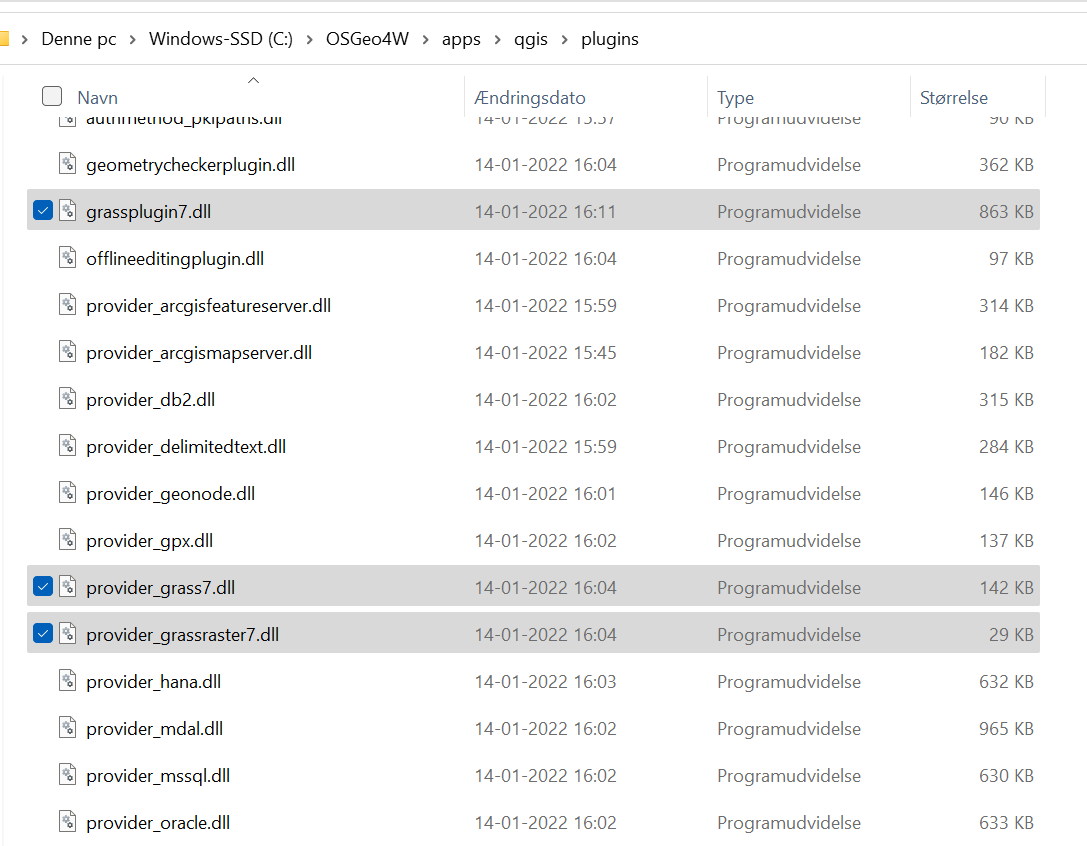
2022-02-04T15:21:36     WARNING    Failed to load C:/OSGeo4W/apps/qgis/plugins/grassplugin7.dll (Reason: Cannot load library C:\OSGeo4W\apps\qgis\plugins\grassplugin7.dll: The module was not found.)
2022-02-04T15:21:36     WARNING    Failed to load C:/OSGeo4W/apps/qgis/plugins/provider_grass7.dll (Reason: Cannot load library C:\OSGeo4W\apps\qgis\plugins\provider_grass7.dll: The module was not found.)
2022-02-04T15:21:36     WARNING    Failed to load C:/OSGeo4W/apps/qgis/plugins/provider_grassraster7.dll (Reason: Cannot load library C:\OSGeo4W\apps\qgis\plugins\provider_grassraster7.dll: The module was not found.)
But it seems that the files are in the library at the exact path:
For me it seems that my paths are wrong. Therefore I tried to make the paths more simple, but it didn't work, so now I am back to default settings.
Does somebody out there have a solution? I am not skilled in coding, so I prefer a solution which doesn't consist of coding. Otherwise I need some guidance.
OBS: There is an Ø (danish letter) in some of the paths, where I have typed (...). Could that be the reason for my error?

