-1

I wish to convert GPS co-ordinates of an object (say, a car) to a relative trajectory.

So suppose I'm travelling from A to B, at A I need to know the precise x-y-z co-ordinate from my current point (which is A) to, say the next GPS co-ordinate (a little bit away from A) which I can then execute, repeating the process above to reach my destination.

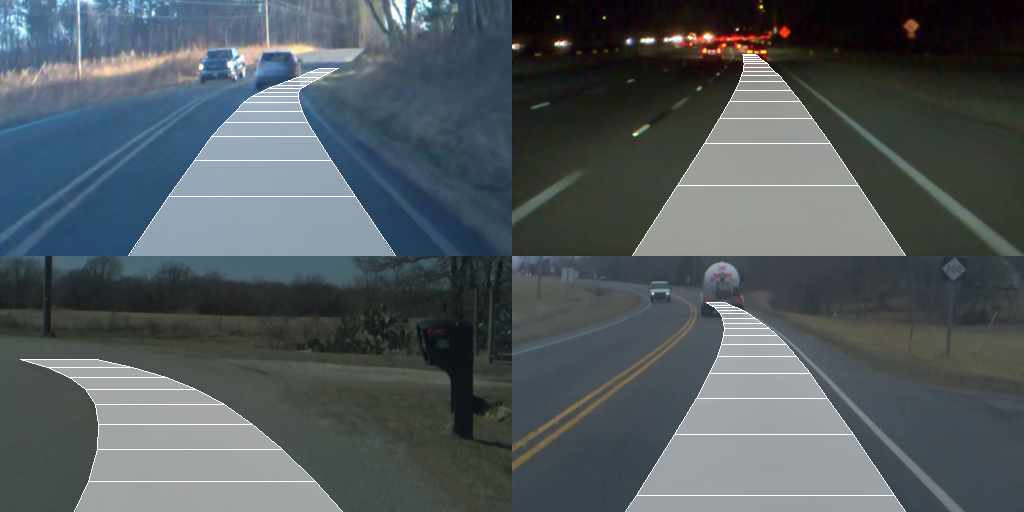
So really, it's finding the relative trajectory of where I should go, using the GPS data given. Here's a linked example:- enter image description here

Source: https://blog.comma.ai/end-to-end-lateral-planning/

I want to perform this operation on the BDD100K dataset.

7
  • 1
    Computing the bearing and distance between two lat/lon points is just the second problem of geodesy (aka inverse or reverse). You should use a geodetic library, since coding the partial differential equation solution on your own will take much longer.
    – Vince
    Commented May 29, 2022 at 16:00
  • Thanks! It appears there's a python library called PyGeodesy If its not too much trouble for you, could you briefly write an answer to what 'task' this process is called, and what functions have to be executed to perform the same? :)
    – neel g
    Commented May 29, 2022 at 19:26
  • so in your example A becomes the origin and based on A you want to identify relative coordinates of B ? If yes, then its like translation of x,y,z coordinates to new origin ? Just wanted to confirm if my understanding is correct.
    – Abhilshit
    Commented May 31, 2022 at 19:52
  • Is this a homework question? Looks like one to me.
    – Trams
    Commented May 31, 2022 at 20:57
  • @Abhilshit close - at every point in our journey, we have access to the next GPS coordinate. so from what I understand (which could be wrong) its the relative trajectory from the current GPS point to the next one. You can try and visualize it to ensure its correct, if it looks like what I posted
    – neel g
    Commented May 31, 2022 at 22:13

2 Answers 2

0

So I understand that you have a set of trajectories and you want to convert these trajectories into relative trajectories by making the first point as origin. Let's take an example of following trajectory

trajectory = [[72.90106773376465,19.11997972844786,203],
      [72.90165781974792,19.119878358645423,203],
      [72.90237665176392,19.119685755849503,203],
      [72.90259122848511,19.11964520786387,203],
      [72.902752161026,19.119564111862754,203],
      [72.90287017822266,19.11954383785625,203]]

It appears like this when plotted enter image description here
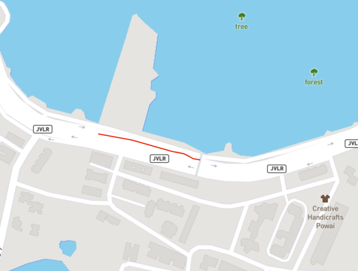
I would first convert this trajectory into ECEF or UTM coordinates, since these are meter based coordinates, so it would be easy to normalize and translate them to new origin. Once done I would subtract the coordinates of first point of the trajectory from all the other of the trajectory.

i.e if coordinates of first point is x1,y1,z1 we will do X-x1, Y-y1, Z-z1, where X, Y, Z represent each point coordinate in the trajectory. Thus the first point is set to (0,0,0) and rest ot the points are relative to this now.

Here is the code to do this. I use pyproj for conversions.


from pyproj import Transformer

coords = [[72.90106773376465,19.11997972844786,203],
          [72.90165781974792,19.119878358645423,203],
          [72.90237665176392,19.119685755849503,203],
          [72.90259122848511,19.11964520786387,203],
          [72.902752161026,19.119564111862754,203],
          [72.90287017822266,19.11954383785625,203]]

def lla_to_ecef_pyproj(lat, lon, alt):
    transformer = Transformer.from_crs("epsg:4326", "epsg:4978")
    x, y, z = transformer.transform(lon, lat, alt)
    return x, y, z

def relative_by_first_coord(trajectory):
    first_point_x, first_point_y, first_point_z = trajectory[0]
    translated_trajectory = []
    for point in trajectory:
        new_x = point[0]-first_point_x
        new_y = point[1]-first_point_y
        new_z = point[2]-first_point_z
        translated_trajectory.append([new_x,new_y,new_z])
    return translated_trajectory

if __name__ == '__main__':
    ecef_converted_trajectory = []
    for pt in coords:
        ecef_converted_trajectory.append(lla_to_ecef_pyproj(pt[0], pt[1], pt[2]))
    print("#### ECEF COORDS ####")
    print(ecef_converted_trajectory)
    print("#### RELATIVE COORDS ####")
    relative_trajectory = relative_by_first_coord(ecef_converted_trajectory)
    print(relative_trajectory)

The above code prints following output

#### ECEF COORDS ####
[(1772556.6357742352, 5762167.471603105, 2075968.7476994193), (1772498.372090993, 5762189.239816475, 2075958.1453859464), (1772428.1327407553, 5762218.151895516, 2075938.0009548392), (1772406.9850470952, 5762226.1949371165, 2075933.760016046), (1772391.6645347767, 5762233.983678933, 2075925.2781322717), (1772380.0116577018, 5762238.337023567, 2075923.1576600387)]

#### RELATIVE COORDS ####
[[0.0, 0.0, 0.0], [-58.263683242257684, 21.768213369883597, -10.602313472889364], [-128.50303347990848, 50.68029241077602, -30.746744580101222], [-149.65072714001872, 58.72333401162177, -34.987683373270556], [-164.97123945853673, 66.51207582838833, -43.46956714754924], [-176.62411653343588, 70.86542046256363, -45.590039380593225]]

In case you need relative sub-trajectories based on the current location you are on, you can execute this iteratively for sub-trajectories. For eg. if you have a trajectory with 4 points [A,B,C,D], while at A you need B's location relative to A, and while at B you need C's location relative to B like that, you need to run the above code iteratively for sub trajectories or just for the next point with respect to current point
0

My approach would be more "brute for and pig ignorance" and is simple enough that (1) you don't need to use libraries, and (2) you should understand what the calculation is doing. The starting point is to use flat earth calculations (because vehicle trajectory distances are very short so using spherical geometry is a waste) and to work with a spherical earth (again, at short ranges, using an ellipsoidal earth is unnecessary.)

Basic information:

  • 1 minute of Latitude is 1852M (moving South or North of the equator, lines of Latitude stay the same distance apart)
  • 1 minute of Longitude is 1852M * Cos(Latitude) (moving South or North of the equator, lines of Longitude get closer together)

Then if you have two points, (Lat1, Long1, Alt1) and (Lat2, Long2, Alt2) we get the following by simple trigonometry:

DeltaAlt = Alt2-Alt1 // Alt in M or whatever units you want, HAE or AMSL doesn't matter as long as both are the same

DeltaLat = (Lat2-Lat1)*1852M // Latitudes must be converted to minutes of Arc

DeltaLong = (Long2-Long1)*Cos(Lat1)*1852M // Longitudes must be converted to minutes of Arc and make sure units for Lat1 match what the "Cos" function expects

HorizontalDistance = Sqrt(DeltaLat * DeltaLat + DeltaLong * DeltaLong)

These calculations are only valid for "short" distances in earth scale - but I've happily used them for points 10s of km apart, the results are "close" to online haversine calculations. (I recommend the Moveable Type site as a reference for distance / bearing calculations.)

2
  • I think he wants to localize the trajectory in the image space and plot it on the image. That's what I could infer from last comment he made on the question.
    – Abhilshit
    Commented Jun 2, 2022 at 21:37
  • 1
    @Abhilshit: You could be right. My suggestion would allow derivation of a series of North / East / Up steps which could be applied to the previous end point. The rest would be "left to the user".
    – Trams
    Commented Jun 3, 2022 at 1:06

Your Answer

By clicking “Post Your Answer”, you agree to our terms of service and acknowledge you have read our privacy policy.

Not the answer you're looking for? Browse other questions tagged or ask your own question.