48

I was talking with a potential client, and they requested that we plot some points with GPS, with a maximum (or should that be minimum?) accuracy of 2 m.

This is an area with no WAAS, and I was under the impression that even in the best of conditions, a single gps point can be accurate up-to only 15 meters(Horizontal field). Is this correct?

What is the maximum theoretical accuracy of GPS without using WAAS or differential GPS?

1
  • 1
    According to the Wikipedia entry, "GPS receivers released in 2018 that use the L5 band can have much higher accuracy, pinpointing to within 30 centimetres or 11.8 inches". Commented Nov 8, 2019 at 20:56

4 Answers 4

31

The United States government currently claims 4 meter RMS (7.8 meter 95% Confidence Interval) horizontal accuracy for civilian (SPS) GPS. Vertical accuracy is worse. Mind you, that's the minimum. Some devices/locations reliably (95% of the time or better) can get 3 meter accuracy. For a technical document on that specification you can go here.

For more general GPS accuracy information, head to GPS.gov's website. That website also includes data and information on WAAS-enabled systems and accuracy levels depending on location. It's a great resource.

Basically, you can't get 2 meter accuracy reliably without some form of correction.

Edit: Something else to contemplate is using a device that can communicate with both GPS and GLONASS satellites. I'm not aware of any accuracy articles or studies that combine both systems to improve accuracy, but at the very least, it increases the potential satellites that may be available at one particular location/time, especially near the poles.

3
  • @prosti - on handheld device, the major limitations are a) antenna length/quality and b) battery consumption tradeoffs in the circuitry. Commented Apr 7, 2019 at 14:55
  • This answer is pretty old (7 years!). So, can we say that we've improved in the accuracy for the civilian GPS? If yes, then what's the maximum accuracy we can reach?
    – Mooncrater
    Commented Aug 16, 2019 at 12:39
  • GPS.gov's SPS performance doc hasn't changed since 2008. They make no greater claim today than they did 7 years ago. However, if you go read their website today, it does say that global average URE was 0.716 meters at 95% on May 11, 2016. But that was just one day. They also mention that they are working on an improvement to accuracy of the GPS system, but that it isn't implemented yet. Additionally, they mention that most smartphones can get around 4.9 meter accuracy. Either way, the answer to this question is still valid: You can't reliably get <2 meters without some form of correction.
    – Baltok
    Commented Aug 16, 2019 at 13:39
18

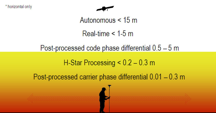
Ionospheric delay effects are the largest source of error in a single-frequency GPS receiver. WAAS and CORS are able to correct for this better than a receiver's almanac, so the best you can do with uncorrected GPS is typically about 15 meters. Survey-grade GPS using RTK is able to achieve centimeter accuracy.

Differential correction methods Image source: http://www.spatial-ed.com/gps/gps-basics/135-differential-correction-methods.html

6

These are results of tests carried out in October and December 2014. Tested were the following GPS telemetry, GPS data loggers and a hand held GPS.

GPSFlight STX900e telemetry, embedded GPS unit ublox LEA - S5

BRB 900 MHz GPS Telemetry, Lassen IQ series GPS receiver

TLA 900 MHz GPS Telemetry, ublox 6 series GPS receiver

Holux 1200e GPS data logger

Tripmate 852 GPS data logger, GPS chipset, MTK

Garmin etrex H

The benchmarks were 2 state survey marks (SSM) 35 km apart in Sydney, Australia. The data sheets for these marks were provided by NSW Spatial Exchange. Devices were left on the marks for 15 minutes at mark 1 and 30 minutes at mark 2.

All devices are DGPS capable.

All use WGS 84 height datum

Mark 1 (60% sky view approx)
Mark 2 (80% sky view approx) Deviation from position, altitude

GPSFlight 1= 9.5 ft, 18.4 ft (7 sats)
2= 3.5 ft, 4.6 ft (10 sats)

BRB 1= 11.9 ft, 16.2 ft (7 sats)
2= 13.6 ft, 3.7 ft (10 sats)

TLA 1= 12.6 ft, 14.8 ft (7 sats)
2= 14.2 ft, 3.6 ft (10 sats)

Holux 1= 29.3 ft, 40.3 ft (7 sats)
2= 9.8 ft, 20.4 ft (10 sats)

Tripmate 1= 18.5 ft, 27.3 ft (7 sats)
2= 7.1 ft, 1.6 ft (10 sats)

Garmin 1= 45.6 ft, 10.8 ft (6 sats)

2= 13.5, ft, 23.0 ft (10 sats)

Looking at the data from these readings, all these GPS unit's positional data "drift" around the static mark but on average give very acceptable accuracy for my purpose IMO. I would think that these devices would need to be left for 1 hour to stabilise properly. I use these GPS devices on World kite altitude record flights and in the remote zone I use and at altitudes up to 16,000 ft, there are 12 or even 13 satellites acquired. That's way more than most people seem to get in urban or forested areas. Any of these units will give me better than 0.08% accuracy over my height profile. If you want better accuracy then you need something like a Trimble Total Station or a similar survey grade GPS with additional augmentation. It depends on how much you pay and your understanding of the usage and limitations. People sometimes have unrealistic expectations of what is wonderful technology at a dirt cheap price. I originally paid $600 for the GPSFlight telemetry 9 years ago. The BRB was $300, TLA around $250, Garmin etrex $99, Holux $100, Tripmate $50. I can remember handheld readily available GPS units were close to $800 about 20 years ago. They are getting cheaper and cheaper but I cannot vouch for the quality or accuracy of all cheap units. Manufacturers of consumer grade GPS units usually make claims of sub 3 meter for position and sub 5 meters for altitude under good conditions. It seems it's still tremendous bang for buck seeing these devices can place you within a 10 meter square on the surface of the earth with 40 billion square metres.

0
6

In European countries, out in the field (not inside a city with buildings), the best accuracy without any aid is 5 meters. I have also witnessed a 2 meter accuracy but that is extremely rare and I would not take it into account. The average best would be 15 meters and the average worse close to 30-40 meters.

The results stated above are from my own field work and come from using various types of smartphones. GPS accuracy greatly varies depending on surroundings, devices used, weather and many other factors. The accuracy results are derived from comparing my actual position with the GPS position.

0

Not the answer you're looking for? Browse other questions tagged or ask your own question.