2

I have about 45 polygons that refer to parcels of land and I want to create the same attribute table for all of them and edit the information/prices afterwards depending on the parcel.

"Joining" doesn't help because it doesn't allow editing afterwards and my table has twelve columns. I was also searching for a way to "Duplicate" using an Excel file but I didn't find anything.

Can anyone help me with that?

2
  • So, you have 45 layers?
    – Erik
    Commented Nov 2, 2022 at 15:07
  • After your join export that to a new layer. You will be able to edit that. This thread might be helpful. gis.stackexchange.com/questions/395821/…
    – John
    Commented Nov 2, 2022 at 16:29

2 Answers 2

1

Try the "Drop geometries" geoalgorithm in the iterative mode.

Creates a simple geometryless copy of the input layer attribute table. It keeps the attribute table of the source layer.

If the file is saved in a local folder, you can choose between many file formats.

0

You can create a "data only" layer, based e.g. on a csv you load to QGIS. In this case, as you correctly say, you can't edit the data in QGIS.

The trick is: you can export this "attribute table only"-layer to a Geopackage and than join it to all your layers. So you will be able to edit the attributes inside QGIS and still have the advantage of joining it to several layers. Be aware, however: if you change the data, it will be changed in any joined layer as well!

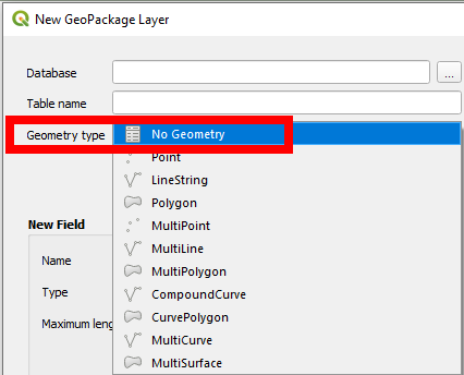
You could also create a new layer from scratch ond choose Geomtry Type as no geometry, see:

enter image description here

Your Answer

By clicking “Post Your Answer”, you agree to our terms of service and acknowledge you have read our privacy policy.

Not the answer you're looking for? Browse other questions tagged or ask your own question.