8

I posted Is there projection issue with Natural Resources Canada (NRC) Canada Atlas hydrology data? describing a shift in some of the NRC data (not all).

Apparently, this shift has to do with conversion between Geographic coordinates, latitude and longitude and Transverse Mercator Grid coordinates.

Can someone please provide a guide on how to do this transformation in ArcGIS Desktop?

I would like to transform that data to either Clarke_1866_Lambert_Conformal_Conic or GCS_WGS_1984.

Source Data Coordinate System:

GCS_WGS_1984
Angular Unit: Degree (0.017453292519943299)
Prime Meridian: Greenwich (0.000000000000000000)
Datum: D_WGS_1984
Spheroid: WGS_1984
Semimajor Axis: 6378137.000000000000000000
Semiminor Axis: 6356752.314245179300000000
Inverse Flattening: 298.257223563000030000
2
  • 4
    800 meters is too much for a datum difference--definitely between NAD83 and WGS84, and also between NAD27 and WGS84. If you did download the LCC data (in e00 format), is the GCS listed as Clarke 1866? Ugh. That's the default spheroid used if a datum isn't specific when using ArcInfo workstation. The data itself could be NAD27- or NAD83- or WGS84-based. But even if the datum was misdefined, 800 m is a more than I normally see.
    – mkennedy
    Commented Dec 16, 2010 at 17:36
  • I redownloaded e00 instead of shapefile. Shift is the same. The coverage Projection is as follows: Projection GEOGRAPHIC Datum NAD83 Zunits NO Units DD Spheroid GRS1980 Xshift 0.0000000000 Yshift 0.0000000000 Commented Dec 16, 2010 at 19:54

2 Answers 2

14

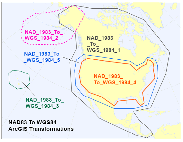
Responding to the question in the subject line and ignoring the body, please see About geographic transformations and how to choose the right one. The quick list:

  1. NAD_1983_To_WGS_1984_1 - for the entire North American continent.
  2. NAD_1983_To_WGS_1984_2 - for the Aleutian islands.
  3. NAD_1983_To_WGS_1984_3 - for Hawai'i.
  4. NAD_1983_To_WGS_1984_4 - superseded by _5; this transformation method should no longer be used!
  5. NAD_1983_To_WGS_1984_5 - for the 48 contiguous United States.
  6. NAD_1983_To_WGS_1984_6 - for the Canadian province of Quebec.
  7. NAD_1983_To_WGS_1984_7 - for the Canadian province of Saskatchewan.
  8. NAD_1983_To_WGS_1984_8 - for the Canadian province of Alberta.

Note that geographic transformations work in either direction. For example, the transformation listed as NAD_1983_To_WGS_1984_5 transforms from NAD 1983 to WGS 1984, as well as from WGS 1984 to NAD 1983.

Map of North American datum transformations
(pic from Does Re-Projecting ShapeFile only update content of *.prj file?)

2
  • Thanks Matt. This a nice graphical guide! I received a reply from NRC in regards to my data shift. It appears I was doing things correctly and the shift is within tolerance (800m) which according to Geogratis falls well within the horizontal accuracy of the data (1000m for 1:1,000,000) Commented Dec 17, 2010 at 0:50
  • Oh yes. And this is of course the answer. I posted the actual reply from NRC in regards to the shift in my previous post if anyone's interested. gis.stackexchange.com/questions/4479/… Commented Dec 17, 2010 at 1:18
1

The accepted answer and image above is out of date. For Canada:

Transformation 2 should be used for NAD83_CSRS to WGS84 Transformation 5 or ITRF00 can be used for NAD83 (original) to WGS 84 but essentially does the same thing as transformation 2. A more correct transformation for NAD83 original is to transform to CSRS using the provincial grid shift files (available from the provincial geodesist or open data site) and then use transformation 2.

Transformation 1 just redefines the data without transforming it at all.

Transformation 2 for CSRS and ITRF00 for NAD83 (original) are the default transformations in Esri software now.

3
  • "Transformation 2 for CSRS and ITRF00 for NAD83 (original) are the default transformations in Esri software now."
    – Malcolm
    Commented Nov 30, 2018 at 20:14
  • Do you mean ArcGIS Pro? In my experience, data exported and converted (NAD83 to WGS84) using ArcGIS Pro does does not match data exported from ArcMap 10.6 or QGIS using the same method. ArcMap does not have a default transformation set between NAD83 and WGS84, while Pro does. It seems that QGIS also uses no transformation.
    – Malcolm
    Commented Nov 30, 2018 at 20:21
  • 2
    Can you define what you mean when you say Transformation 2, Transformation 5, etc.?
    – Rex
    Commented Apr 24, 2019 at 20:54

Your Answer

By clicking “Post Your Answer”, you agree to our terms of service and acknowledge you have read our privacy policy.

Not the answer you're looking for? Browse other questions tagged or ask your own question.